Ōtāhuhu
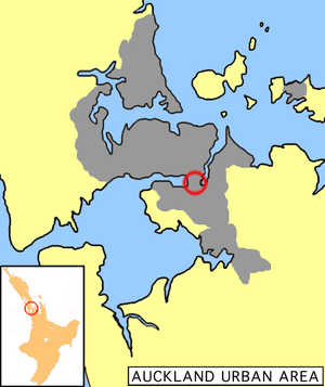
Ōtāhuhu is a suburb of Auckland, New Zealand – 13 kilometres (8.1 mi) to the southeast of the CBD, on a narrow isthmus between an arm of the Manukau Harbour to the west and the Tamaki River estuary to the east. The isthmus is the narrowest connection between the North Auckland Peninsula and the rest of the North Island, being only some 1,200 metres (3,900 ft) wide at its narrowest point, between the Otahuhu Creek and the Mangere Inlet. As the southernmost suburb of the former Auckland City, it is considered part of South Auckland.
Ōtāhuhu | |
|---|---|
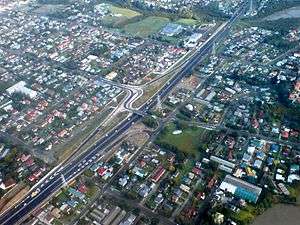 Part of eastern Otahuhu from the air | |
 | |
 Ōtāhuhu | |
| Coordinates: 36°56′43″S 174°50′42″E | |
| Country | New Zealand |
| Local authority | Auckland Council |
| Population (2001) | |
| • Total | 11,991 |
| Train station(s) | Otahuhu railway station |
| Westfield | Mount Wellington | (Tamaki River), Pakuranga |
| (Mangere Inlet) |
|
(Tamaki River), East Tamaki |
| Favona, Mangere East | Middlemore |
The suburb's name is taken from the Māori-language name of a volcanic cone also known as Mount Richmond. The name refers to "the place of Tāhuhu"—an ancestor, Tāhuhu-nui-a-Rangi, who settled the area. In colloquial speech, locals sometimes shorten the name to "Otahu".
History
The suburb was established in 1847 as a fencible settlement, where soldiers were given land with the implied understanding that in wartime, they would be raised as units to defend it (however, the eventual fighting a decade later used professional soldiers instead). Most early features from this time have disappeared, however, such as a stone bridge built by the fencibles that had to make way to a widening of Great South Road.[1]
Otahuhu was home to the country's first supermarket, and Otahuhu College, to which several famous personalities went, including heavyweight boxing champion David Tua, former prime minister David Lange, and ex-Manukau City Mayor, Sir Barry Curtis.
Local government
Otahuhu had a local government just like other suburbs of Auckland at that time. The local government was called Otahuhu Borough Council, which started in 1912 and merged into Auckland City Council in 1985, eventually amalgamated into Auckland Council in November 2010.
Mayors during Otahuhu Borough Council
- Alfred Sturges, 1912–1915
- James Atkinson, 1915–1917
- Alfred MacDonald, 1917–1921
- Robert Black Todd, 1921–1929
- Hubert Thomas Clements, 1929–1935
- Charles Robert Petrie, 1935–1944
- Albert Murdoch, 1944–1950
- James Deas, 1950–1954
- John "Jack" David Murdoch, 1954–1962
- Robert G. Ashby, 1962–1965
- Aubray Thayer Bedingfield, 1965–1970
- Claude H. D. Handisides, 1970–1977
- Niall Frederick Burgess, 1977–1985
Transport
Otahuhu, in its position on a narrow section of the Auckland isthmus, is an important part of Auckland's southern transportation approaches for both road and rail, containing a combined bus interchange and Otahuhu railway station. The new bus-train interchange opened on 29 October 2016 as a joint Auckland Transport and New Zealand Transport Agency initiative costing NZ$28M.[2][3]
"The station is at the heart of the Southern New Network", said Auckland Transport’s Chief AT Metro Officer, Mark Lambert. “Auckland is moving towards a more connected network of local feeder services connecting with frequent bus and train services. Bus and train transport hubs like Otahuhu are at the heart of this transformation."[4]
The old bus interchange, which was badly neglected, and had received increased attention from early 2011 on for vandalism/graffiti prevention measures is now closed and a smaller bus stop has been installed on the main road near the town centre.[5]
The importance for transportation extended to pre-European times. The aptly named Portage Road runs across the isthmus in Otahuhu and was used by Māori to move their waka (canoes) between the Manukau and Waitemata harbours for raids and trading. In fact, the area, also known as Te Tō Waka, was considered the most important portage of all of New Zealand.[6][7]
Present day
Otahuhu nowadays is synonymous with industry and along with its neighbouring suburbs Favona, Mangere East, Mt Wellington, Penrose and Westfield forms an industrial conglomerate zone that spans much of the Mangere Inlet. The community and town centre flourishes as the crossroad to Central and South Auckland and is home to a sizable Pacific Island populace.
Sport and recreation
Otahuhu is home to the Otahuhu Rugby Football Club and the Otahuhu Leopards rugby league club.
References
- "Auckland: Soldiers of fortune". The New Zealand Herald. 26 August 2010. Retrieved 5 February 2011.
- "New Otahuhu Station and a New Network for South Auckland". Auckland Transport. Retrieved 25 October 2016.
- "New Otahuhu Station to open for new network". Stuff.co.nz. 27 October 2016. Retrieved 27 October 2016.
- "Auckland Transport – New Otahuhu Station and a New Network for south Auckland". Auckland Transport. 29 October 2016. Retrieved 5 February 2017.
- "Press release: Otahuhu Bus Station Clean Up Begins". Auckland Transport. 14 January 2011. Retrieved 17 January 2011.
- "Maori Tribal History – Hongi's Expeditions". Te Ara: The Encyclopedia of New Zealand. Retrieved 17 January 2011.
- "Other northern canoes – Te Tō Waka – the canoe portage". Te Ara: The Encyclopedia of New Zealand. Retrieved 17 January 2011.
External links
- Photographs of Otahuhu held in Auckland Libraries' heritage collections