Favona
Favona is a mostly industry-dominated suburb of Auckland, New Zealand, and is part of the Mangere area. The suburb is in the Manukau ward, one of the thirteen administrative divisions of Auckland city, and is under governance of the Auckland Council.
Favona | |
|---|---|
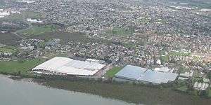 Favona from the air, looking south. | |
 Favona | |
| Coordinates: 36°57′9″S 174°48′1″E | |
| Country | New Zealand |
| Local authority | Auckland Council |
| Electoral ward | Manukau |
| Population (2001) | |
| • Total | 5,934 |
| Mangere Bridge | (Mangere Inlet / Manukau Harbour) | (Mangere Inlet / Manukau Harbour) |
| Mangere Bridge |
|
Otahuhu, (Harania Creek) |
| Mangere | Mangere | Mangere East |
The area has a long history of habitation, due to its fertile lands, a productive harbour, and proximity to the Manukau-Tamaki isthmus. Māori of Ngāti Whātua were the inhabitants until they were supplanted by European farmers in the 19th century. The development of market gardening brought more people into the area and the land remained used in this way until the 1960s when housing developments were created to service Auckland's growing population and industry in nearby Onehunga and Otahuhu. Some areas of Favona also historically had large areas of greenhouses, such as for tomato production.[1]
The area is one is of relative poverty and until 2005 had one of New Zealand's largest Caravan parks. It hosts the Mangere campus of Te Wananga o Aotearoa. Numerous shipping and freight forwarding companies have premises in the industrial areas,[2] including the national distribution headquarters of supermarket chain Progressive Enterprises.
References
- Taylor, Colin (14 February 2010). "Greenfields sale sparked by zone change". The New Zealand Herald. Retrieved 12 December 2010.
- Falconer, Phoebe (26 September 2006). "Get moving: Giving way to confusion". The New Zealand Herald. Retrieved 30 September 2011.