Omsukchan
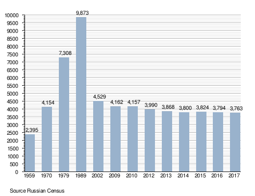
Omsukchan (Russian: Омсукча́н) is an urban locality (an urban-type settlement) and the administrative center of Omsukchansky District of Magadan Oblast, Russia, located 576 kilometers (358 mi) north of Magadan. Population: 4,157 (2010 Census);[1] 4,529 (2002 Census);[5] 9,873 (1989 Census).[6]
Omsukchan Омсукча́н | |
|---|---|
Urban-type settlement | |
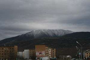 View of Omsukchan | |
Location of Omsukchan 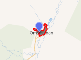
| |
 Omsukchan Location of Omsukchan 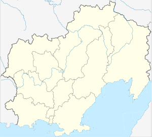 Omsukchan Omsukchan (Magadan Oblast) | |
| Coordinates: 62°30′40.6″N 155°47′01.4″E | |
| Country | Russia |
| Federal subject | Magadan Oblast |
| Administrative district | Omsukchansky District |
| Founded | 1930 |
| Population | |
| • Total | 4,157 |
| • Estimate (2018)[2] | 3,758 (-9.6%) |
| Time zone | UTC+11 (MSK+8 |
| Postal code(s)[4] | 686410 |
| OKTMO ID | 44704000051 |
History
Omsukchan was founded in the 1930s after natural resources were discovered in the region. It was granted urban-type settlement status in 1953.
The settlement's name comes from Omchikan, which means "little marsh" in the Even language.
Geography
Omsukchan is a mountain town that lies in the western shore of Sugoy River, a tributary of Kolyma River. It is 27 km east of Dukat, the other town in the raion, and 22 km north of the ghost town of Galimy. The Omsukchan Range, highest ridge of the Kolyma Mountains, rises to the west and northwest of the town.[7]
Demographics
Economy
The economy is based on extraction of gold, silver and coal.[8]
Transport
Omsukchan has a 250 km road to the R504 Kolyma Highway, and has the Omsukchan Airport. There are regular bus and flight connections to Magadan.[8]
The Anadyr Highway is under construction east from Omsukhan towards Anadyr.
Climate
Omsukchan has a subarctic climate, with average temperatures ranging from −29.6 °C (−21.3 °F) in January to +13.4 °C (56.1 °F) in July.
| Climate data for Omsukchan | |||||||||||||
|---|---|---|---|---|---|---|---|---|---|---|---|---|---|
| Month | Jan | Feb | Mar | Apr | May | Jun | Jul | Aug | Sep | Oct | Nov | Dec | Year |
| Daily mean °C (°F) | −29.6 (−21.3) |
−28.5 (−19.3) |
−22.1 (−7.8) |
−12.7 (9.1) |
−3.3 (26.1) |
8.5 (47.3) |
13.4 (56.1) |
9.3 (48.7) |
−1.5 (29.3) |
−11.1 (12.0) |
−22.8 (−9.0) |
−29.3 (−20.7) |
−10.5 (13.1) |
| Source: NASA RETScreen Database | |||||||||||||
See also

References
- Russian Federal State Statistics Service (2011). "Всероссийская перепись населения 2010 года. Том 1" [2010 All-Russian Population Census, vol. 1]. Всероссийская перепись населения 2010 года [2010 All-Russia Population Census] (in Russian). Federal State Statistics Service.
- "26. Численность постоянного населения Российской Федерации по муниципальным образованиям на 1 января 2018 года". Federal State Statistics Service. Retrieved January 23, 2019.
- "Об исчислении времени". Официальный интернет-портал правовой информации (in Russian). June 3, 2011. Retrieved January 19, 2019.
- Почта России. Информационно-вычислительный центр ОАСУ РПО. (Russian Post). Поиск объектов почтовой связи (Postal Objects Search) (in Russian)
- Russian Federal State Statistics Service (May 21, 2004). "Численность населения России, субъектов Российской Федерации в составе федеральных округов, районов, городских поселений, сельских населённых пунктов – районных центров и сельских населённых пунктов с населением 3 тысячи и более человек" [Population of Russia, Its Federal Districts, Federal Subjects, Districts, Urban Localities, Rural Localities—Administrative Centers, and Rural Localities with Population of Over 3,000] (XLS). Всероссийская перепись населения 2002 года [All-Russia Population Census of 2002] (in Russian).
- "Всесоюзная перепись населения 1989 г. Численность наличного населения союзных и автономных республик, автономных областей и округов, краёв, областей, районов, городских поселений и сёл-райцентров" [All Union Population Census of 1989: Present Population of Union and Autonomous Republics, Autonomous Oblasts and Okrugs, Krais, Oblasts, Districts, Urban Settlements, and Villages Serving as District Administrative Centers]. Всесоюзная перепись населения 1989 года [All-Union Population Census of 1989] (in Russian). Институт демографии Национального исследовательского университета: Высшая школа экономики [Institute of Demography at the National Research University: Higher School of Economics]. 1989 – via Demoscope Weekly.
- 1,000,000 scale Operational Navigation Chart; Sheet D-8
- Официальная информация об Омсукчане и Омсукчанском районе. (in Russian). Retrieved April 1, 2018.
External links
| Wikimedia Commons has media related to Omsukchan. |
- Information about Omsukchan (in Russian)
- Omsukchan on geographic.org
Administrative center: Magadan • Rural localities | |||
| Districts | |||
| Cities and towns | |||
| Urban-type settlements | |||