Ohio State Route 169
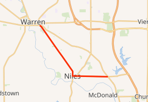
State Route 169 (SR 169) is a state highway in the northeastern portion of the U.S. state of Ohio that is signed north–south, but trends more east–west. The southern (eastern) terminus of SR 169 is at a signalized intersection with U.S. Route 422 (US 422) just east of Niles. The northern (western) terminus of the highway is at a signalized intersection with US 422 in Warren.
| ||||
|---|---|---|---|---|
| ||||
| Route information | ||||
| Maintained by ODOT | ||||
| Length | 6.764 mi[1] (10.886 km) | |||
| Existed | 1923–present | |||
| Major junctions | ||||
| South end | ||||
| North end | ||||
| Location | ||||
| Counties | Trumbull | |||
| Highway system | ||||
| ||||

Route description
From its southern terminus at US 422 and Tibbetts Neck Road, SR 169 heads west along the two-lane Robbins Avenue in Weathersfield Township through a mostly residential neighborhood. About 1⁄3 mile (0.54 km) in, it enters the city of Niles and gains a center turn lane. As the road enters the downtown area, more businesses line the road. At Vienna Avenue, SR 46 joins SR 169 on a 0.3-mile (0.48 km) concurrency through the city. The highway becomes four lanes wide as it passes under a pair of railroad bridges. Robbins Avenue ends at Main Street where SR 46 heads south and SR 169 heads north. Along Main Street, the highway has a total of four lanes (a mix of through and turning lanes), passes under the same railroad previously crossed, and turns northwest. As SR 169 exits Niles for Weathersfield Township and later Howland Township, its name changes to Niles Road and reduces to two lanes passing through a mixed commercial/residential area. After entering the city of Warren, it passes Oakwood Cemetery and crosses a railroad at-grade before ending at the intersection of US 422 (South Street) and Chestnut Avenue.[2]
The entirety of SR 169 exists within Trumbull County. No part of this route is inclusive within the National Highway System.[3]
History
SR 169 was created in 1923 as a northeast bypass of Niles, with SR 16 going through Niles.[4] In 1927, SR 169 was moved to SR 16's routing through Niles, and the Niles bypass became part of the newly-designated US 422.[5][6] Until August 2007, SR 169 ran west with US 422 in Warren to the SR 45 intersection.[7][8]
Major intersections
The entire route is in Trumbull County.
| Location | mi[1] | km | Destinations | Notes | |
|---|---|---|---|---|---|
| Weathersfield Township | 0.000 | 0.000 | |||
| Niles | 2.184 | 3.515 | Southern end of SR 46 concurrency | ||
| 2.480 | 3.991 | Northern end of SR 46 concurrency | |||
| Warren | 6.764 | 10.886 | |||
1.000 mi = 1.609 km; 1.000 km = 0.621 mi
| |||||
References
- Ohio Department of Transportation (August 30, 2017). "Technical Services DESTAPE - Trumbull County" (PDF). Retrieved April 26, 2019.
- Google (April 26, 2019). "Ohio State Route 169" (Map). Google Maps. Google. Retrieved April 26, 2019.
- National Highway System: Ohio (PDF) (Map). Federal Highway Administration. December 2003. Retrieved September 14, 2010.
- Ohio Department of Highways and Public Works (July 1923). Map of Ohio Showing State Routes (PDF) (Map). 1:760,320. Columbus: Ohio Department of Highways and Public Works. Retrieved March 28, 2019.
- Ohio Department of Highways and Public Works (August 1, 1926). Map of Ohio Showing State Routes (PDF) (Map). 1:760,320. Columbus: Ohio Department of Highways and Public Works. OCLC 5673562. Retrieved March 28, 2019.
- Ohio Department of Highways and Public Works (June 1, 1927). Map of Ohio Showing State Routes (PDF) (Map). 1:760,320. Columbus: Ohio Department of Highways and Public Works. OCLC 5673562. Retrieved March 28, 2019.
- "SR 169 Straight Line Diagram" (PDF). ODOT. January 2003. Archived from the original (PDF) on September 27, 2004. Retrieved April 26, 2019.
- "Trumbull County Updates". ODOT. 2008. Archived from the original on February 26, 2012. Retrieved April 26, 2019.
SR 0169R - Route Reversed, Overlap Removed, J.E. 8/17/2007