Oecusse
Oecusse, also variously Oecussi, Ocussi, Oekussi, Oekusi, Okusi, Oé-Cusse, and formerly Ambeno and Oecussi-Ambeno, is both a municipality and a Special Administrative Region, and was formerly a district, of East Timor.
Oecusse Oekusi | |
|---|---|
Municipality and Special Administrative Region | |
 A padrão in Lifau marks the spot where the Portuguese first landed on Timor in 1515. | |
 Flag  Seal | |
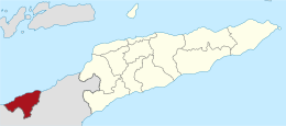 Map of East Timor highlighting Oecusse SAR | |
| Coordinates: 9°20′S 124°18′E | |
| Country | |
| Capital | Pante Macassar |
| Administrative posts |
|
| Area | |
| • Total | 814 km2 (314 sq mi) |
| Area rank | 8th |
| Population (2015 census) | |
| • Total | 68,913 |
| • Rank | 6th |
| • Density | 85/km2 (220/sq mi) |
| • Density rank | 4th |
| Households (2015 census) | |
| • Total | 14,345 |
| • Rank | 6th |
| Time zone | UTC+09:00 (TLT) |
| ISO 3166 code | TL-OE |
| HDI (2017) | 0.553[1] medium · 13th |
A coastal exclave in the western part of the island of Timor, Oecusse is separated from the rest of East Timor by West Timor, which is part of the province of Nusa Tenggara Timur, Indonesia, and which surrounds Oecusse in all directions except the north, where it borders the Savu Sea.
The capital of Oecusse is Pante Macassar, also called Oecussi Town, or formerly, in Portuguese Timor, Vila Taveiro. Originally Ambeno was the name of the former district and Oecussi its capital.[2]
Geography
Overview

Oecusse has an area of 814 square kilometres (314 sq mi).
Climate
| Climate data for Oecusse (1919–1963) | |||||||||||||
|---|---|---|---|---|---|---|---|---|---|---|---|---|---|
| Month | Jan | Feb | Mar | Apr | May | Jun | Jul | Aug | Sep | Oct | Nov | Dec | Year |
| Record high °C (°F) | 32.3 (90.1) |
31.3 (88.3) |
33.4 (92.1) |
34.6 (94.3) |
34.8 (94.6) |
33.8 (92.8) |
33.2 (91.8) |
33.8 (92.8) |
34.7 (94.5) |
35.4 (95.7) |
33.6 (92.5) |
32.0 (89.6) |
35.4 (95.7) |
| Average high °C (°F) | 29.7 (85.5) |
29.3 (84.7) |
29.8 (85.6) |
30.4 (86.7) |
30.7 (87.3) |
30.3 (86.5) |
29.6 (85.3) |
29.1 (84.4) |
28.8 (83.8) |
29.4 (84.9) |
30.6 (87.1) |
30.3 (86.5) |
29.8 (85.6) |
| Daily mean °C (°F) | 27.3 (81.1) |
27.0 (80.6) |
27.2 (81.0) |
27.6 (81.7) |
27.7 (81.9) |
27.1 (80.8) |
26.2 (79.2) |
26.0 (78.8) |
26.3 (79.3) |
27.5 (81.5) |
28.4 (83.1) |
27.9 (82.2) |
27.2 (81.0) |
| Average low °C (°F) | 24.9 (76.8) |
23.6 (74.5) |
23.1 (73.6) |
22.8 (73.0) |
22.8 (73.0) |
22.0 (71.6) |
20.8 (69.4) |
20.4 (68.7) |
20.3 (68.5) |
22.0 (71.6) |
23.6 (74.5) |
23.8 (74.8) |
22.5 (72.5) |
| Record low °C (°F) | 20.5 (68.9) |
21.6 (70.9) |
19.0 (66.2) |
20.4 (68.7) |
18.5 (65.3) |
16.0 (60.8) |
15.6 (60.1) |
16.4 (61.5) |
17.0 (62.6) |
18.0 (64.4) |
20.9 (69.6) |
21.8 (71.2) |
15.6 (60.1) |
| Average precipitation mm (inches) | 282.0 (11.10) |
228.6 (9.00) |
205.5 (8.09) |
89.0 (3.50) |
36.6 (1.44) |
7.7 (0.30) |
6.2 (0.24) |
2.6 (0.10) |
1.3 (0.05) |
15.6 (0.61) |
54.2 (2.13) |
177.3 (6.98) |
1,106.6 (43.57) |
| Average precipitation days (≥ 0.1 mm) | 16 | 15 | 13 | 7 | 2 | 1 | 1 | 0 | 0 | 2 | 5 | 14 | 76 |
| Average relative humidity (%) | 78 | 78 | 76 | 74 | 68 | 63 | 65 | 67 | 71 | 76 | 75 | 77 | 72 |
| Mean monthly sunshine hours | 182.9 | 166.7 | 248.0 | 264.0 | 294.5 | 279.0 | 297.6 | 310.0 | 351.0 | 316.2 | 294.0 | 235.6 | 3,239.5 |
| Mean daily sunshine hours | 5.9 | 5.9 | 8.0 | 8.8 | 9.5 | 9.3 | 9.6 | 10.0 | 11.7 | 10.2 | 9.8 | 7.6 | 8.8 |
| Source: Deutscher Wetterdienst[3] | |||||||||||||
History
Oecusse and Ambeno are the names of the two original kingdoms, of which Ambeno existed before the colonial period.
Oecusse was among the first parts of the island of Timor on which the Portuguese established themselves, and is thus usually considered the cradle of East Timor. In about 1556, the Dominican friar António Taveiro, operating from a base on Solor, started missionary work on the north coast of Timor. Shortly after this, in 1569, the village of "Alifao" (Lifau) is mentioned on a European map. It was situated five kilometres to the west of modern Pante Macassar.[4] For the Portuguese traders in sandalwood, Lifau was a convenient place to land since it was situated to the south of their base in the Solor Archipelago. The area was dominated by the Ambeno kingdom, which was sometimes referred as the kingdom of Lifau. In 1641 the Dominican priests baptised the royal families of the Ambeno, Mena and Amanuban kingdoms, which meant that Portuguese influence increased in parts of western Timor. Migration of Topasses, a Eurasian population, rose in the 1650s from Larantuka on Flores. After 1664 they were governed by officers belonging to the Hornay and Da Costa families, and were able to dominate most of Timor. The Topass leaders used Lifau as their main stronghold on Timor, but still resided much of their time in Larantuka. In the second half of the seventeenth century they made great profits through the sandalwood trade, attracting merchants from Siam, Batavia, Macao, and Goa in India. The precious wood was brought to Lifau and sold to external traders under Topass supervision.[5]
In 1702, Lifau became the authorised capital of the colony when it received the first governor from Goa. The following period saw frequent clashes between the governor and the independent-minded Topasses, who had their strongholds in Tulicão west of Lifau, and Animata in the inland. Under their leader Gaspar da Costa they attacked the Dutch colonial post at Kupang in 1749 but were smashingly defeated, and subsequently moved their residence to Pante Macassar (Oecusse) in 1759 due to Dutch military pressure. The capital of the governor was transferred from Lifau to Dili in 1769, because of the frequent attacks from the Topass leader Francisco Hornay III. Most of West Timor was left to Dutch forces, who were conquering what is today Indonesia. The Eurasian leadership of Oecusse by and by turned into a Timorese kingship, and members of the Hornay and Da Costa families reigned as Liurai (kings) until modern times. They regularly intermarried with the Ambeno royalty. In the 1780s a reconciliation took place between the governor in Dili and the Topasses, who henceforth usually supported the Portuguese government.[6]
In 1859, with the Treaty of Lisbon, Portugal and the Netherlands divided the island between them. West Timor became Dutch, with its colonial seat at Kupang, and East Timor became Portuguese, with its seat in Dili. This left Oecusse and Noimuti as enclaves surrounded by Dutch territory. In 1912 the Liurai of Ambeno, João da Cruz, staged a revolt against the Portuguese. It was quickly put down, after which the Ambeno kingdom lapsed. The Liurai of Oecusse became dominant in the entire Oecusse exclave.[7] The definitive border was drawn by the Hague in 1916. Apart from Japanese occupation during World War II, the border remained the same until the end of the colonial period. The region was given the status of county (conselho), named Oecússi, by the Portuguese government in August 1973, the last Timorese area to receive it.
Indonesian forces invaded Oecusse on 6 June 1975. In October they occupied the western border districts of East Timor's main territory. It was in Pante Macassar that an Indonesian fifth column raised the Indonesian flag on 29 November 1975, a week before the official Indonesian invasion of East Timor proper. However, even under Indonesian rule, Oecusse was administered as part of the province of East Timor, as it had been as part of Portuguese Timor. Like much of the country, it suffered violent attacks near the 1999 referendum for independence. Over 90 percent of the infrastructure was destroyed. It became part of the independent state of East Timor on 20 May 2002.
In the 1970s and 1980s, New Zealander anarchist Bruce Grenville began a hoax, claiming to have founded the sultanate of Occussi-Ambeno. He invented a history for the state of tribes united against the Portuguese, and produced many cinderella stamps for his creation.[8]
On 11 November 1999, 600+ Australian troops from 3RAR (Third Battalion, Royal Australian Regiment) deployed from Maliana in East Timor proper to Oecusse to liberate the enclave. They stayed there until late February 2000, being replaced by Jordanian troops.
Politics
Articles 5 and 71 of the 2002 constitution provide that Oetcussi Ambeno be governed by a special administrative policy and economic regime. Law 03/2014 of 18 June 2014 created the Special Administrative Region of Oecusse Ambeno (Região Administrativa Especial de Oecusse Ambeno, RAEOA). A national development programme to implement governmental policy, called ZEESM TL (Special Zones of Social Market Economy of Timor-Leste) is in place.[9] The President of RAEOA & ZEESM TL is Mari Alkatiri, a former Prime Minister of East Timor.[10]
The East Timor government that established the ZEESM TL programme was hoping that it would bring economic sustainability before the country's oil and gas reserves run out.[11] During a visit to Oecusse in November 2015, the then Prime Minister, Rui Maria de Araújo, claimed that the government's investment in the Region would benefit all people in East Timor, not just those in Oecusse.[12] However, there has been criticism of the programme's lack of transparency and accountability, and its absence of any public cost-benefit or risk analysis, or any significant private investment.[11] Questions have also been raised as to whether the programme is one that is necessarily appropriate for the area, or likely to be in the best interests of its citizens.[13]
According to one commentator, many observers of East Timor's strategic investment choices have wondered, "Why is the government of a country comprised of [largely] subsistence farmers obsessed with glitzy prestige projects at the expense of more pressing needs such as health and agriculture?"[14] Yet the same commentator has also noted, more recently, that the imposition of the programme generated a plurality of opinions and reactions in Oecusse, mostly eliciting curiosity and the will to cautiously negotiate solutions. Not only did the local population adapt to the programme and endure significant changes in their lifestyles; additionally, some aspects of the programme were modified in some significant detail to accommodate deep and strongly expressed popular sentiments.[15]
Administrative posts
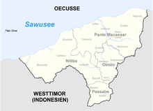

Oecusse is divided into four administrative posts (formerly sub-districts):[16][17]
- Nitibe
- Oesilo
- Pante Macassar (with capital Pante Macassar)
- Passabe
The administrative posts are divided into 18 sucos ("villages") in total.
Demographics
Population
According to the 2015 Census, Oecusse has a population of 68,913 people, divided into 14,345 households.
The Atoni, one of many indigenous ethnic groups, number about 20,000 in the SAR. A much larger number live in the surrounding part of West Timor.
Languages
The native language of most residents is Uab Meto (Meto), often referred to by outsiders as Baikeno. Portuguese is used in education and government, although despite its status as an official language there are few fluent speakers.
Although Indonesian was used as a lingua franca until 1999, since then it has been almost completely replaced in this role by Tetum which is the primary language of government, education and public life and is spoken and understood in all but very remote areas of the SAR.
Religion
99.3% of the inhabitants are Roman Catholic and 0.6% Protestant. There were 36 Hindus, 21 Muslims, 10 Animists and one Buddhist in the 2010 census.
Transport

Air
The new Oecusse or Rota do Sandalo International Airport was inaugurated by East Timorese President Fransisco Guterres on 18 June 2019[18][19] and serves as the main gateway to Oecusse. The airport was previously an airstrip located at the edge of Pante Macassar and was refurbished at a cost of US$119 million.[20] Previously, there were six return flights a week to and from the East Timor capital Dili.
Road
Main roads link Pante Macassar to Sakato 15 km to the east, and Bobometo to the south-east, both of which are on the East Timor-Indonesia border and are official border crossings into Indonesia.[21][22] The integrated border post at Sakato (also spelled Sacato) is the major crossing for Oecusse as it is on the shortest land route between Oecusse and East Timor proper via the border crossing at Mota'ain/Batugade. The Indonesian checkpoint across the border from Sakato is Wini. The Bobometo border crossing (with Napan on the Indonesian side) in on the road to Kefamenanu.
A network of minor roads link other areas within Oecusse Municipality with Pante Macassar and the capitals of administrative posts. In 12 June 2017 a bridge over the Tono River was inaugurated by the president of Timor-Leste, Francisco Guterres.[23] The Noefefan Bridge connects the isolated regions to the west of the Tono River to Pante Macassar, providing them permanent access to markets, the ferry and airport, even during the rainy season (November to April).[24]
Roads also lead to minor border crossings in Passabe (with Haumeniana also in North Central Timor Regency) and Citrana (with Oepoli in Kupang Regency), mostly catering to crossings by residents of border villages.[21]
References
- "Sub-national HDI - Area Database - Global Data Lab". hdi.globaldatalab.org. Retrieved 2018-09-13.
- "Archived copy" (PDF). Archived from the original (PDF) on 2009-10-01. Retrieved 2014-02-28.CS1 maint: archived copy as title (link)
- "Klimatafel von Ocussi, Insel Timor / Ost-Timor" (PDF). Baseline climate means (1961-1990) from stations all over the world (in German). Deutscher Wetterdienst. Retrieved 29 January 2016.
- Frédéric Durand, Timor: 1250-2005, 750 ans de cartographie et de voyage. Toulouse: Arkuiris 2006, p. 65.
- Hans Hägerdal, 'Rebellions or factionalism? Timorese forms of resistance in an early colonial context, 1650-1769', Bijdragen tot de Taal-, Land- en Volkenkunde 163:1 2007, pp. 10-14.
- C.R. Boxer, The Topasses of Timor. Amsterdam: Indisch Instituut te Amsterdam 1947.
- R. Pelissier, Timor en guerre: Le crocodile et les portugais (1847-1913). Orgeval 1996, pp. 274-277, 299-301.
- Hayward, Philip (November 2019). "Oecusse and the Sultanate of Occussi-Ambeno: Pranksterism, misrepresentation and micronationality" (PDF). Small States & Territories. 2 (2): 183–194.
- "ZEESM TL & RAEOA – ZEESM TL". www.zeesm.tl. Retrieved 2017-10-03.
- "East Timor set to swear in Mari Alkatiri as PM". www.aljazeera.com. Retrieved 2017-10-03.
- Davidson, Helen (25 May 2017). "Timor-Leste's big spending: a brave way to tackle economic crisis or just reckless?". The Guardian. Retrieved 31 October 2018.
- "Prime Minister visits Oe-cusse Ambeno". Government of Timor-Leste. 7 November 2015. Retrieved 1 November 2018.
- Rose, Michael (February 2017). "'Development', resistance and the geographies of affect in Oecussi: Timor‐Leste's Special Economic Zone (ZEESM)". Singapore Journal of Tropical Geography. 38 (2): 201–215, at 212. doi:10.1111/sjtg.12190. Retrieved 1 November 2018.
- Meitzner Yoder, Laura (December 2015). "The development eraser: fantastical schemes, aspirational distractions and high modern mega-events in the Oecusse enclave, Timor-Leste". Journal of Political Ecology. 22 (1): 299, at 315. doi:10.2458/v22i1.21110. Retrieved 1 November 2018.
- Meitzner Yoder, Laura S (2017). "Chapter 7: Reconceptualizing land and territory in Oecusse Ambeno enclave's special economic zone". In Viegas, Susana de Matos; Feijó, Rui Graça (eds.). Transformations in Independent Timor-Leste: Dynamics of Social and Cultural Cohabitations. London: Routledge. ISBN 9781315534992.
- "Oe-Cusse Suco Reports". Timor-Leste Ministry of Finance.
- Gunn, Geoffrey C (2011). Historical Dictionary of East Timor. Lanham, Maryland: Scarecrow Press. p. 134. ISBN 9780810867543.
- "Oé-Cusse International Airport "Rota Do Sândalo" (Sandalo Route) Has Been Inaugurated". ZEESM TL. Retrieved 2019-07-04.
- "After Oecusse Airport, Wika eyes more in Timor Leste". The Jakarta Post. Retrieved 2019-07-04.
- "Oecusse Airport built by WIKA has been inaugurated | IDNFinancials". www.idnfinancials.com. Retrieved 2019-06-25.
- "Immigration Service of Timor Leste: About Us". Immigration Service of Timor Leste. Retrieved 11 June 2019.
- "Inauguration of Integrated Border Post- Sakato, Oecusi". Ministry of Finance Timor Leste. Retrieved 10 June 2019.
- "Inauguration of Noefefan bridge in Oecusse Ambeno". Government of Timor Leste. Retrieved 11 June 2019.
- "Noefefan Bridge Inaugurated". ZEESM TL. Retrieved 11 June 2019.
- Planet, Lonely. "Nakroma Ferry in Oecussi". Lonely Planet. Retrieved 2017-10-03.
- "Lei N.º 3/2014 de 18 de Junho Cria a Região Administrativa Especial de Oe-Cusse Ambeno e estabelece a Zona Especial de Economia Social de Mercado" (PDF), Jornal da República, Série I, N.° 21, 18 de Junho de 2014, 7334-7341
External links
| Wikimedia Commons has media related to Oe-Cusse Ambeno. |
- Union of Capital Cities of the Portuguese Language (in Portuguese)
- Association of Soldiers of Oecusse (in Portuguese)
- La’o Hamutuk: Special Economic Zone in Oecusse (in English & Tetum)
- Oecusse Enclave
- Official Timor-Leste Regional Governmental Website: for RAEOA and ZEESM TL: www.zeesm.tl