Baucau Municipality
Baucau (Portuguese: Município Baucau, Tetum: Munisípiu Baukau) is a municipality, and was formerly a district, of East Timor,[2] on the northern coast in the eastern part of the country. The capital is also called Baucau (formerly Vila Salazar). The population of the municipality is 111,694 (census 2010) and it has an area of 1,506 km².
Baucau Baukau | |
|---|---|
.jpg) Osolata beach | |
 Flag | |
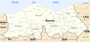
 Map of East Timor highlighting Baucau Municipality (borders of 2003 to 2015) | |
| Coordinates: 8°35′S 126°30′E | |
| Country | |
| Capital | Baucau |
| Subdistricts | |
| Area | |
| • Total | 1,506 km2 (581 sq mi) |
| Area rank | 4th |
| Population (2015 census) | |
| • Total | 123,203 |
| • Rank | 3rd |
| • Density | 82/km2 (210/sq mi) |
| • Density rank | 5th |
| Households (2015 census) | |
| • Total | 22,976 |
| • Rank | 3rd |
| Time zone | UTC+09:00 (TLT) |
| ISO 3166 code | TL-BA |
| HDI (2017) | 0.602[1] medium · 9th |
Geography
The borders of the then District of Baucau during the colonial era were the same as they are now. The north edge of the municipality is to the Wetar Strait; it also borders the municipalities of Lautém to the east, Viqueque to the south, and Manatuto to the west.
Baucau also has a wide coastline with sandy beaches, ideal for swimming and other watersports.
In the administrative post of Venilale are tunnels that the Japanese built during their occupation in the Second World War. Also in this administrative post is an ongoing project to reconstruct and renovate the Escola do Reino de Venilale (School of the Kingdom of Venilale).[3]
Administrative posts
The municipality's administrative posts (formerly sub-districts) are:[4]
Demographics
Besides the national official languages of Tetum and Portuguese, most of the inhabitants speak the Papuan language Makasae. While most of the inhabitants are Roman Catholics, a few Muslims also live there.
Economy
Baucau has the most highly developed agriculture in East Timor. Besides the staples rice and corn, Baucau produces beans, peanuts, sweet potatoes, copra, candlenut and manioc. It also raises buffalo and goats. A shortage of transportation links and the unpredictability of energy availability stymie the development of emerging industries.
Infrastructure
Baucau has the country's longest airport runway, in Cakung Airport,[5] as currently, Dili's Nicolau Lobato International Airport can only serve small airliners like the Boeing 737. The airport is located six km from the city of Baucau. It served as the country's principal airport before the Indonesian invasion in 1975, when it was taken over by the Indonesian military. Bucoli, a village with symbolic role in the East Timorese resistance movement, is located in the subdistrict of Baucau.
References
- "Sub-national HDI - Area Database - Global Data Lab". hdi.globaldatalab.org. Retrieved 2018-09-13.
- James Norman (11 February 2017). "Environmental concerns for Timor-Leste cement project". The Saturday Paper. Retrieved 2017-02-22.
- "Escola do Reino de Venilale". GERTiL. 2004. Archived from the original on 2006-05-03. Retrieved 2017-02-22.
- Gunn, Geoffrey C (2011). Historical Dictionary of East Timor. Lanham, Maryland: Scarecrow Press. p. 49. ISBN 9780810867543.
- Joanna Podgórska (10 April 2010). "Trzy katastrofy - trzy zamachy? Nr 3: Smoleńsk Siewiernyj, 10.04.2010". na:Temat. Retrieved 2017-02-22.
External links
![]()