Nundkol Lake
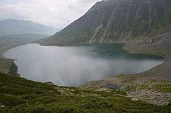
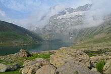
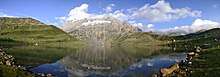
The Nundkol Lake or Nund Kol also known as Kalodaka Lake is an oligotrophic alpine lake situated in the Kashmir Valley, in Ganderbal district of Jammu and Kashmir, India.[1]
| Nundkol Lake | |
|---|---|
 | |
| Location | Ganderbal, Jammu and Kashmir, India |
| Coordinates | 34.417855°N 74.935663°E |
| Lake type | oligotrophic lake |
| Primary inflows | Gangbal Lake |
| Primary outflows | Sind River |
| Max. length | 1.2 kilometres (0.75 mi) |
| Max. width | 0.5 kilometres (0.31 mi) |
| Surface area | 1.5 km2 (0.58 sq mi) |
| Surface elevation | 3,505 metres (11,499 ft) |
Geography
The Nundkol Lake lies at the foothills of Mount Haramukh (5,142 metres (16,870 ft)). The Gangbal Lake which is bigger and at higher elevation lies 1.5 km to the north of the lake. Surrounded by the lush green meadows, the banks of the Nundkol Lake serve as the camping site during the summers. Naranag is the nearest settlement and serves as the base camp for trekking to the lake.[2][3]
The Nundkol Lake is fed by Gangbal Lake and the melting glaciers of the Mount Haramukh. It gives rise to Wangath Nallah, the major right tributary of the Sind River.[3][4]
Flora and fauna
During the winter, the Nundkol Lake freezes and is covered by heavy snow. In the summers, the basin of the lake is surrounded by a sheet of alpine flowers. The geum, blue poppy, potentilla and gentian are relatively common. Hedysarum flowers are found in late spring throughout the area around the lake.[5]
The Nundkol Lake is stocked with trout among of which is the brown trout. The fishing is permitted to the licensed anglers.[6]
Access
The Nundkol Lake is accessible only during the summer; during the winter, the treks are closed because of the heavy snowfall. It can be reached from Srinagar, via a 65 km motorable road which leads through Ganderbal and Wayil to the Naranag trekking camp. The alpine meadows of Trunakhul and Badpathri lies at the halfway point of this two-day trek to the lake. An alternate trek starts from Chattergul village, 10 km to the west of Naranag which leads through the meadows of Mahlish. The lake can also be accessed through Bandipora and the five-day trekking starting point is Arin. Tourists prefer Naranag trek and return via Gadsar Lake, Vishansar Lake and Sonamarg to cover most alpine lakes of the area.[7][8]
References
- Raj Kumar (1997). Proceedings of the Indian History Congress, Volume 57. Indian History Congress, 1997. p. 198. ISBN 9780975022870.
- John, Sludmak (2013). The Hindu-Buddhist Sculpture of Ancient Kashmir and Its Influences Handbook of Oriental Studies. Section 2 South Asia Volume 28 of Handbuch der Orientalistik: Indien, ISSN 0169-9377. BRILL, 2013. p. 498. ISBN 9789004248328.
- Garry Weare (2007). A Long Walk in the Himalaya: A Trek from the Ganges to Kashmir. DoctorZed Publishing, 2007. pp. 276–. ISBN 9780975022870.CS1 maint: extra punctuation (link)
- "Sacred Shrines of Haramukh". dailyexcelsior.com. Retrieved 9 July 2013.
- Samsar Chand Koul (1971). Beautiful valleys of Kashmir and Ladakh. L. Koul, 1971. pp. 116–. ISBN 9788173871078.CS1 maint: extra punctuation (link)
- T. Petr, Deep Bahadur Swar (2002). Cold Water Fisheries in the Trans-Himalayan Countries Issue 431 of FAO Fisheries Technical Paper, Food and Agriculture Organization, ISSN 0429-9345. Food & Agriculture Org., 2002. pp. 25–. ISBN 9789251048078.CS1 maint: extra punctuation (link)
- "Naranag-Gangabal Trek". KashmirTreks. Retrieved 27 October 2013.
- M. S. Kohli (1983). The Himalayas: Playground of the Gods - Trekking, Climbing and Adventures. Indus Publishing, 1983. pp. 38, 39–. ISBN 9788173871078.CS1 maint: extra punctuation (link)