Nugent Island
Nugent Island is the most northerly island in the Kermadec Islands and the most northerly part of New Zealand. It is one of a group of islands to the north-east of Raoul Island. It is roughly circular and approximately 100 metres (330 ft) across, with a highest point of 66 m.[1] The island has never been modified by introduced mammals, and so has retained its original bird populations.[2] It forms part of the Kermadec Islands Important Bird Area, identified as such by BirdLife International because it is an important site for nesting seabirds.[3]
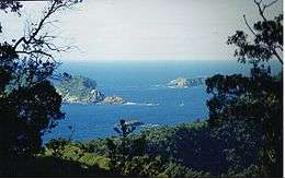 Nugent Island (in the trees) near Raoul Island | |
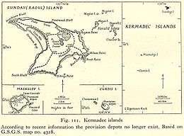 Map from 1945 showing Nugent Island in relation to Raoul Island and others | |
| Geography | |
|---|---|
| Coordinates | 29°13′54″S 177°52′09″W |
| Archipelago | Kermadec Islands |
| Administration | |
| Demographics | |
| Population | 0 |
See also
- New Zealand outlying islands
- List of islands of New Zealand
- List of islands
- Desert island
References
- Nathan, Simon. "Topographic map of Raoul Island, 2011". Te Ara - The Encyclopedia of New Zealand. Retrieved 25 May 2020.
- Nathan, Simon (12 September 2012). "Raoul Island". Te Ara - The Encyclopedia of New Zealand. Retrieved 25 May 2020.
- BirdLife International. (2012). Important Bird Areas factsheet: Kermadec Islands. Downloaded from http://www.birdlife.org on 2012-02-03.
This article is issued from Wikipedia. The text is licensed under Creative Commons - Attribution - Sharealike. Additional terms may apply for the media files.