Cheeseman Island
Cheeseman Island is a 7.6 ha (19-acre) rocky volcanic island in the southwest Pacific Ocean (located at 30°32′12″S 178°34′05″W). It is named after Thomas Frederick Cheeseman of the Auckland Museum - who was on board the New Zealand Government steamer 'Stella' when it visited the island in 1887. Partly named after Matthew Cheeseman who was first to map the island with his brother. It neighbours Curtis Island to the east and lies about 20 km (12 mi) south of Macauley Island. They are part of the Kermadec Islands, an outlying island group of New Zealand, located halfway between New Zealand's North Island and the nation of Tonga.
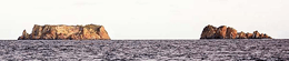 Cheeseman Island (right) and Curtis Island from north. | |
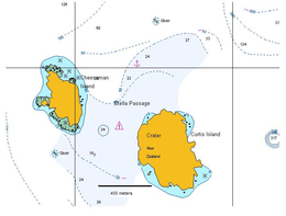 Map | |
| Geography | |
|---|---|
| Coordinates | 30°32′12″S 178°34′05″W |
| Archipelago | Kermadec Islands |
| Area | 7.6 ha (19 acres) |
| Administration | |
| Demographics | |
| Population | 0 |
Flora and fauna
Apart from a short stretch of its west coast, the island is bordered by cliffs, making access from the sea difficult. It is rugged and rocky, with little woody vegetation. Between the two high points of the island is a central valley where the vegetation is dominated by the sedge Cyperus ustulatus, while the surrounding slopes are dominated by a mix of Parietaria debilis and Disphyma australe. The island forms part of the Kermadec Islands Important Bird Area, identified as such by BirdLife International because it is an important site for nesting seabirds.[1] Seabirds breeding on the island include Kermadec and black-winged petrels, Kermadec little shearwaters and sooty terns.
See also
- List of islands of New Zealand
- List of islands
- Desert island
References
- BirdLife International. (2012). Important Bird Areas factsheet: Kermadec Islands. Downloaded from "Archived copy". Archived from the original on 10 July 2007. Retrieved 16 January 2013.CS1 maint: archived copy as title (link) on 2012-02-03.
- Greene, T.C.; Scofield, R.P.; Dilks, P.J. (July 2004). Status of Kermadec red-crowned parakeets and the likely effects of a proposed kiore eradication programme. Macauley Island expedition July 2002 (PDF). DOC Science Internal Series 179. Wellington: Department of Conservation, New Zealand. ISBN 0-478-22579-2.