North Little Rock, Arkansas
North Little Rock is a city in Pulaski County, Arkansas, United States, across the Arkansas River from Little Rock in the central part of the state. The population was 62,304 at the 2010 census. In 2019 the estimated population was 65,903,[3] making it the seventh-most populous city in the state. North Little Rock, along with Little Rock and Conway, anchors the six-county Little Rock–North Little Rock–Conway Metropolitan Statistical Area (2014 population 729,135), which is further included in the Little Rock-North Little Rock Combined Statistical Area with 902,443 residents.
North Little Rock, Arkansas | |
|---|---|
 North Little Rock across the Arkansas River | |
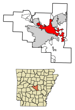 Location of North Little Rock in Pulaski County, Arkansas | |
 North Little Rock, Arkansas Location in the United States | |
| Coordinates: 34°46′51″N 92°15′25″W | |
| Country | United States |
| State | Arkansas |
| County | Pulaski |
| Founded | 1866 - Argenta established |
| Incorporated | 1890 - incorporation of Argenta; merged with unincorporated North Little Rock in 1903 |
| Government | |
| • Mayor | Joe Smith |
| Area | |
| • City | 55.49 sq mi (143.71 km2) |
| • Land | 52.34 sq mi (135.55 km2) |
| • Water | 3.15 sq mi (8.16 km2) |
| Elevation | 266 ft (81 m) |
| Population | |
| • City | 62,304 |
| • Estimate (2019)[3] | 65,903 |
| • Rank | US: 524th |
| • Density | 1,259.41/sq mi (486.26/km2) |
| • Urban | 431,388 (US: 88th) |
| • Metro | 729,135 (US: 75th) |
| Time zone | UTC−6 (CST) |
| • Summer (DST) | UTC−5 (CDT) |
| ZIP codes | 72114-119, 721124, 72190, 72199 |
| Area code(s) | 501 |
| FIPS code | 05-50450 |
| GNIS feature ID | 0077862[4] |
| Website | www.northlittlerock.ar.gov/ |
The city's downtown is anchored in the Argenta Historic District, which draws its name from the original name of the city; the area includes Dickey-Stephens Park, the current home of the Arkansas Travelers minor league baseball team, and Simmons Bank Arena, the metropolitan area's main entertainment venue. Farther west in the city is Burns Park, one of the largest municipal parks in the United States.
History
North Little Rock has a long history, dating back to the Burial Mound People.[5] It was once known as Argenta, a name that currently applies specifically to downtown North Little Rock. In 1890, Little Rock annexed the unincorporated Argenta community as its Eighth Ward, preempting a competing petition to incorporate Argenta. A neighboring area was incorporated as the Town of North Little Rock in 1901 as part of a plan to reclaim the Eighth Ward from Little Rock. By 1904, the Arkansas Supreme Court allowed the town to annex the Eighth Ward; the modern City of North Little Rock considers this its founding date. The combined city adopted the Argenta name by 1906, but reverted to North Little Rock in October 1917. A remnant of the city's earliest years can be found in North Little Rock City Hall (constructed in 1914), which still contains plaques referring to "Argenta", and contains "C of A" (City of Argenta) ornamental designs.
Geography
North Little Rock is located at 34°46′51″N 92°15′25″W (34.780791, -92.256881).[6]
According to the United States Census Bureau, the city has a total area of 47.0 square miles (122 km2), of which 44.8 square miles (116 km2) is land and 2.2 square miles (5.7 km2) (4.58%) is water.
Highways
North Little Rock is also the eastern terminus of Interstate 30 and southern terminus of the Arkansas-designated portion of Interstate 57. Interstate 40, US 65, US 67, and US 167 all run through the city.
Climate
The climate in this area is characterized by hot, humid summers and generally mild to cool winters. According to the Köppen Climate Classification system, North Little Rock has a humid subtropical climate, abbreviated "Cfa" on climate maps.[7]
North Little Rock has a humid subtropical climate with long, hot, and sunny summers and mild, wet winters with little snow. January on average is the coldest month, while July is typically the warmest, but occasionally August can claim the title.[8] The overall yearly average temperature is 62.5 degrees. Precipitation averages 45.79 inches a year, with winter and spring tending to be wetter than summer and autumn.[9] Severe thunderstorms can occur, especially during the Spring, on April 25, 2011, a possible tornado struck the air force base in the city.
| Climate data for North Little Rock, 1981-2016 normals. | |||||||||||||
|---|---|---|---|---|---|---|---|---|---|---|---|---|---|
| Month | Jan | Feb | Mar | Apr | May | Jun | Jul | Aug | Sep | Oct | Nov | Dec | Year |
| Average high °F (°C) | 49.4 (9.7) |
54.5 (12.5) |
64.4 (18.0) |
73.6 (23.1) |
80.2 (26.8) |
87.8 (31.0) |
92.3 (33.5) |
91.9 (33.3) |
84.7 (29.3) |
73.2 (22.9) |
63.6 (17.6) |
51.8 (11.0) |
71.8 (22.1) |
| Average low °F (°C) | 32.7 (0.4) |
36.9 (2.7) |
44.9 (7.2) |
53.4 (11.9) |
59.9 (15.5) |
67.9 (19.9) |
71.9 (22.2) |
70.8 (21.6) |
65.6 (18.7) |
54.0 (12.2) |
44.1 (6.7) |
35.7 (2.1) |
53.3 (11.8) |
| Average precipitation inches (mm) | 3.53 (90) |
3.68 (93) |
5.07 (129) |
4.28 (109) |
4.13 (105) |
3.47 (88) |
3.00 (76) |
1.99 (51) |
2.67 (68) |
3.40 (86) |
4.95 (126) |
5.44 (138) |
45.27 (1,150) |
| Average precipitation days (≥ 0.01 in) | 12.1 | 12.3 | 9.7 | 10.9 | 7.7 | 8.8 | 7.2 | 6.7 | 6.9 | 7.8 | 10.1 | 14.2 | 77.3 |
| Mean monthly sunshine hours | 171.5 | 212.3 | 257.0 | 297.1 | 303.0 | 324.2 | 353.6 | 392.2 | 300.4 | 290.4 | 246.3 | 198.5 | 3,346.5 |
| Percent possible sunshine | 49 | 57 | 65 | 68 | 75 | 77 | 80 | 84 | 74 | 72 | 59 | 53 | 74 |
| Source: NOAA (sun 1961-1990) | |||||||||||||
Demographics
| Historical population | |||
|---|---|---|---|
| Census | Pop. | %± | |
| 1910 | 11,138 | — | |
| 1920 | 14,048 | 26.1% | |
| 1930 | 19,418 | 38.2% | |
| 1940 | 21,137 | 8.9% | |
| 1950 | 44,097 | 108.6% | |
| 1960 | 58,032 | 31.6% | |
| 1970 | 60,040 | 3.5% | |
| 1980 | 64,388 | 7.2% | |
| 1990 | 61,741 | −4.1% | |
| 2000 | 60,433 | −2.1% | |
| 2010 | 62,304 | 3.1% | |
| Est. 2019 | 65,903 | [3] | 5.8% |
| U.S. Decennial Census[10] | |||
As of the census of 2010, there were 62,304 people, 25,542 households, and 16,117 families residing in the city. The population density was 1,348.6 people per square mile (520.7/km²). There were 27,567 housing units at an average density of 615.2 per square mile (237.5/km²). The city was 54.02% White, 39.73% Black or African American, 0.41% Native American, 0.94% Asian, 0.07% Pacific Islander, 2.71% from other races, and 2.14% from two or more races. 5.71% of the population were Hispanic or Latino of any race.
There were 25,542 households out of which 28.9% had children under the age of 18 living with them, 41.9% were married couples living together, 17.6% had a female householder with no husband present, and 36.9% were non-families. 32.0% of all households were made up of individuals and 12.2% had someone living alone who was 65 years of age or older. The average household size was 2.35 and the average family size was 2.97.
In the city, the population was spread out with 25.5% under the age of 18, 9.0% from 18 to 24, 28.4% from 25 to 44, 22.5% from 45 to 64, and 14.6% who were 65 years of age or older. The median age was 36 years. For every 100 females, there were 87.7 males. For every 100 females age 18 and over, there were 82.9 males.
The median income for a household in the city was $35,578, and the median income for a family was $43,595. Males had a median income of $31,420 versus $24,987 for females. The per capita income for the city was $19,662. About 12.4% of families and 16.1% of the population were below the poverty line, including 26.5% of those under age 18 and 11.7% of those age 65 or over.
Government
The City of North Little Rock elected officials are a mayor, city council of city council members (eight total, with two from each of the four wards), city clerk/treasurer, city attorney, and two judges. This is supplemented by a number of boards and commissions composed of city officials and residents.[11]
Police
| North Little Rock | |
|---|---|
| Crime rates* (2012) | |
| Violent crimes | |
| Homicide | 8 |
| Rape | 9 |
| Robbery | 177 |
| Aggravated assault | 255 |
| Total violent crime | 449 |
| Property crimes | |
| Burglary | 1,204 |
| Larceny-theft | 3,894 |
| Motor vehicle theft | 373 |
| Arson | 10 |
| Total property crime | 5,471 |
Notes *Number of reported crimes per 100,000 population. 2012 population: 63,125 Source: 2012 FBI UCR Data | |
The North Little Rock Police Department (NLRPD) has approval to operate unmanned aerial vehicle (UAV)s. The department has been working with a small pilotless helicopter since 2008.[12]
Fire department
In addition to fire and EMS calls, the North Little Rock Fire Department (NLRFD) responds to calls for their Special Operations Response Team, Haz Mat Response Team and Water Rescue for the Arkansas River.[13]
Education
Post-secondary education
- University of Arkansas – Pulaski Technical College
- Shorter College (Arkansas)
- Arkansas College of Barbering and Hair Design
- New Tyler Barber College
- Diesel Driving Academy
- Lee's School of Cosmetology
- The Salon Professional Academy
- National Real Estate School
- U.S. Dept of Veterans Affairs Police Law Enforcement Training Center
Public primary and secondary schools
Most students attend public schools in the North Little Rock School District which includes:
- One High School
- North Little Rock High School grades 9-12
- One Middle School
- one middle school, North Little Rock Middle School, which is subdivided into a 6th grade campus and a 7-8th grade campus.
- Nine Elementary Schools
- Amboy Elementary
- Boone Park Elementary
- Crestwood Elementary
- Glenview Elementary
- Indian Hills Elementary
- Lakewood Elementary
- Meadow Park Elementary
- Ridge Road Elementary (Formerly Ridge Road Middle School)
- Seventh Street Elementary
- One Early Childhood Center
- Pike View Early Childhood Center
The North Little Rock High School West Campus facility is listed on the National Register of Historic Places for its art-deco architecture style.
In addition, the Pulaski County Special School District administers several other North Little Rock area schools, including:
- one middle school, and
- three elementary schools and one elementary magnet school.
Scipio Jones High School, the segregated public school for black children, was established in 1909 and disestablished in 1970.[14]

Private primary and secondary schools
In North Little Rock there are a number of private schools:
- Central Arkansas Christian Schools (PreK3-12)
- Immaculate Conception (K-8)
- North Little Rock Montessori
- North Little Rock Catholic Academy (PreK3-8)
- Formed in 2007 by the merger of St. Mary School and St. Patrick School.[15]
North Little Rock previously had a Catholic grade school for black people, St. Augustine School. It closed in 1976.[16]
Points of interest
_Little_Rock's_Ceremonial_Color_Guard_parades_the_colors_to_officially_open_a_ceremony.jpg)
- Argenta Historic District
- Argenta Community Theater
- Dickey-Stephens Park, home of the Arkansas Travelers baseball team
- Verizon Arena with the Arkansas Sports Hall of Fame Museum
- T. R. Pugh Memorial Park and the Old Mill in the movie Gone With The Wind
- McCain Mall
- Wild River Country water park
- Arkansas River Trail
- Downtown Riverside RV Park
- Arkansas Inland Maritime Museum, and the Navy tug Hoga (YT-146), a survivor of the attack on Pearl Harbor, and the USS Razorback (SS-394), which was at the surrender in Tokyo Bay
- National Weather Service North Little Rock, Arkansas Weather Forecast Office (Closed to Public)
Notable people
- Joey Lauren Adams, actress and director
- Ben M. Bogard, American Baptist Association founder, clergyman in North Little Rock from 1903 to 1909[17]
- Maxine Brown, country singer (of The Browns fame)
- John Burkhalter, businessman and politician
- A. J. Burnett, former Major League Baseball (MLB) pitcher
- Maurice Clemmons, perpetrator of 2009 Lakewood shooting
- Donnie Copeland, Pentecostal pastor and member of the Arkansas House of Representatives for District 38
- Jeremy Davis, bassist for pop-punk band Paramore
- Pat Hays, former mayor of North Little Rock
- Cliff Hoofman, Justice on the Arkansas Supreme Court
- Douglas House, Republican member of the Arkansas House of Representatives from District 40 (Pulaski and Faulkner counties) since 2013
- Jerry Jones, owner of the Dallas Cowboys
- Glenn Myatt, Major League Baseball catcher
- Darren McFadden, Dallas Cowboys running back
- Officer Tommy Norman, North Little Rock Police Officer, known for positive community policing
- Frank Page, radio broadcaster, attended school in North Little Rock
- Charles Robinson, Arkansas State Treasurer
- Mary Steenburgen, actress
- Jason White, guitarist for Green Day
Sister cities
North Little Rock has two sister cities according to Sister Cities International:
References
- "2017 U.S. Gazetteer Files". United States Census Bureau. Retrieved Aug 22, 2018.
- "U.S. Census website". United States Census Bureau. Retrieved 2014-07-09.
- "Population and Housing Unit Estimates". Retrieved May 21, 2020.
- "US Board on Geographic Names". United States Geological Survey. 2007-10-25. Retrieved 2008-01-31.
- See Adams, Walter M., "A History of North Little Rock The Unique City" (1986, August House)(ISBN 0874830028).
- "US Gazetteer files: 2010, 2000, and 1990". United States Census Bureau. 2011-02-12. Retrieved 2011-04-23.
- Climate Summary for North Little Rock
- "North Little Rock, AR Weather Forecast and Conditions - The Weather Channel | Weather.com". The Weather Channel. Retrieved 2017-08-19.
- Data, US Climate. "Climate North Little Rock - Arkansas and Weather averages North Little Rock". www.usclimatedata.com. Retrieved 2017-08-19.
- "Census of Population and Housing". Census.gov. Retrieved June 4, 2015.
- "About Government". City of North Little Rock. Archived from the original on 28 May 2017. Retrieved 17 June 2017.
- Pasztor, Andy (2012-04-21). "Drone Use Takes Off on the Home Front - WSJ.com". Online.wsj.com. Retrieved 2013-07-10.
- "About Fire Department". City of North Little Rock. Archived from the original on 1 December 2017. Retrieved 17 June 2017.
- Hanley, Steven G. and Ray Hanley. Around Little Rock: A Postcard History. Arcadia Publishing, June 1, 1998. ISBN 0738568678, 9780738568676. p. 118.
- Hargett, Malea (2013-03-28). "Despite 'year of grace,' St. Joseph School will close". Arkansas Catholic. Retrieved 2017-07-31.
- Hargett, Malea (2012-05-12). "State's last black Catholic school to close". Arkansas Catholic. Retrieved 2017-07-31.
- "Benjamin Marcus Bogard (1868–1951)". encyclopediaofarkansas.net. Retrieved August 2, 2013.
External links
| Wikimedia Commons has media related to North Little Rock, Arkansas. |
See also
Municipalities and communities of Pulaski County, Arkansas, United States | ||
|---|---|---|
| Cities |  Map of Arkansas highlighting Pulaski County | |
| CDPs | ||
| Unincorporated communities | ||
| Footnotes | ‡This populated place also has portions in an adjacent county or counties | |
| Authority control |
|
|---|