Niscemi
Niscemi is a little town and comune in the province of Caltanissetta, Sicily, Italy. It has a population of 27,558.[3] It is located not far from Gela and Caltagirone and 90 km from Catania.
Niscemi | |
|---|---|
| Comune di Niscemi | |
 Niscemi skyline | |
Location of Niscemi 
| |
 Niscemi Location of Niscemi in Italy 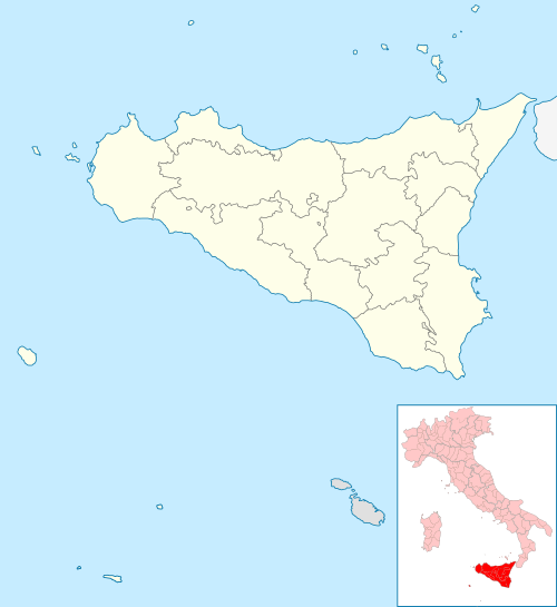 Niscemi Niscemi (Sicily) | |
| Coordinates: 37°09′N 14°23′E | |
| Country | Italy |
| Region | Sicily |
| Province | Caltanissetta |
| Government | |
| • Mayor | Massimiliano Valentino Conti |
| Area | |
| • Total | 96 km2 (37 sq mi) |
| Elevation | 332 m (1,089 ft) |
| Population (December 30, 2016)[2] | |
| • Total | 27,558 |
| • Density | 290/km2 (740/sq mi) |
| Demonym(s) | Niscemesi |
| Time zone | UTC+1 (CET) |
| • Summer (DST) | UTC+2 (CEST) |
| Postal code | 93015 |
| Dialing code | 0933 |
| Patron saint | Madonna Santissima del Bosco |
| Saint day | May 21 |
| Website | Official website |
Etymology
The name Niscemi is derived from the Arabic word نَشَم neshem or its singular form نَشَمَة neshemeh, this being the name of a particular type of tree.
World War II
During World War II, Niscemi was the location of Ponte Olivo Airfield, a military airfield used by the United States Twelfth Air Force during the Italian campaign. After the war the area was redeveloped and no evidence of the wartime airfield remains.
American military installation
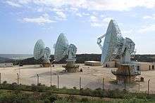
Today, there is a military radio station for naval communication, U.S. Naval Radio Transmitter Facility (NRTF) Niscemi. Its tallest antenna is a guyed mast, 252 metres (827 ft) high, situated at 37°7'32"N 14°26'11"E.
The United States Navy installation is the focus of ongoing protest by locally based activist groups, who oppose it and demand its removal on grounds of health (danger from electromagnetic radiation), environmental damage and opposition to the use of armed drones in the Middle East, allegedly guided from this base.[4] Allegations of armed drones being operated from this base has never been verified however, as the newly installed MUOS (Mobile User Objective System)[5] was intended as an upgrade to legacy communication equipment, and is not intended to communicate with unmanned flying drones. Niscemi inhabitants say the Berlusconi government did not consult them before granting the US the use of the location.
Notes
- "Superficie di Comuni Province e Regioni italiane al 9 ottobre 2011". Istat. Retrieved 16 March 2019.
- "Popolazione Residente al 1° Gennaio 2018". Istat. Retrieved 16 March 2019.
- Istat Data - Population of Niscemi until December 30, 2016
- Nadeau, Barbie Latza (April 28, 2015). "The Tiny Italian Town Killing the U.S. Navy's Surveillance Plans". The Daily Beast. Retrieved August 5, 2016.
- "Navy Satellite Programs" (PDF). Space and Naval Warfare Systems Command. August 2014. Archived from the original (PDF) on 10 February 2017. Retrieved 5 August 2016.
References
![]()
- Maurer, Maurer. Air Force Combat Units of World War II. Maxwell AFB, Alabama: Office of Air Force History, 1983. ISBN 978-0-912799-02-5
External links
| Authority control |
|
|---|