Niemegk
Niemegk (German: [ˈniː.mɛk] (![]()
Niemegk | |
|---|---|
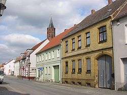 Main road | |
 Coat of arms | |
Location of Niemegk within Potsdam-Mittelmark district 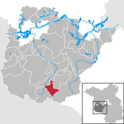 | |
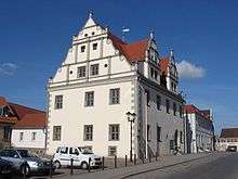
 Niemegk  Niemegk | |
| Coordinates: 52°04′59″N 12°41′59″E | |
| Country | Germany |
| State | Brandenburg |
| District | Potsdam-Mittelmark |
| Municipal assoc. | Niemegk |
| Subdivisions | 2 Ortsteile |
| Government | |
| • Mayor | Hans-Joachim Linthe (SPD) |
| Area | |
| • Total | 44.81 km2 (17.30 sq mi) |
| Elevation | 75 m (246 ft) |
| Population (2018-12-31)[1] | |
| • Total | 2,037 |
| • Density | 45/km2 (120/sq mi) |
| Time zone | CET/CEST (UTC+1/+2) |
| Postal codes | 14823 |
| Dialling codes | 033843 |
| Vehicle registration | PM |
| Website | www.amt-niemegk.de |
Geography
The municipal area is situated on the northeastern slopes of the Fläming Heath, east of the Plane river. The surrounding region comprises farmland and extended forests adjoining the High Fläming Nature Park. The town centre is located about 10 km (6.2 mi) southeast of Bad Belzig, and 23 km (14 mi) north of Wittenberg.
The town has access to the Bundesautobahn 9 highway at the Nimegk junction.
History
A Burgward at the former site of a Slavic fortress (gord) was first mentioned in an 1161 deed, at the time when the Ascanian margrave Albert the Bear conquered the Hevelli lands in the north. The name Nymik or Niemeke is possibly derived from the town of Nijmegen in the Low Countries, the place of origin of German settlers. The estates were held by the Teutonic Order and the former village was vested with town privileges in 1228.
Since the mid 13th century, the area was part of the Ascanian Duchy of Saxe-Wittenberg and, from 1356, of the Saxon electorate. Located on its northeastern border, it was the scene of numerous conflicts with Brandenburg knights and the forces of the Magdeburg archbishops. The town again suffered from Hussite raids in 1429, marauding Imperial troops after the Saxon defeat at the 1547 Battle of Mühlberg, and was devastated in the Thirty Years' War.
After the Napoleonic Wars and the 1815 Congress of Vienna, the town fell to Prussia and was incorporated into the Province of Brandenburg. From 1868, young Robert Koch worked in Niemegk as a country doctor.
Demography
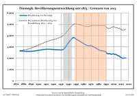
| Niemegk: Population development within the current boundaries (2013)[2] | |||||||||||||||||||||||||||||||||||||||||||||||||||||||||||||||||||||||||||||||||||||||||||||||||||||||||||||||||||||||||||||||
|---|---|---|---|---|---|---|---|---|---|---|---|---|---|---|---|---|---|---|---|---|---|---|---|---|---|---|---|---|---|---|---|---|---|---|---|---|---|---|---|---|---|---|---|---|---|---|---|---|---|---|---|---|---|---|---|---|---|---|---|---|---|---|---|---|---|---|---|---|---|---|---|---|---|---|---|---|---|---|---|---|---|---|---|---|---|---|---|---|---|---|---|---|---|---|---|---|---|---|---|---|---|---|---|---|---|---|---|---|---|---|---|---|---|---|---|---|---|---|---|---|---|---|---|---|---|---|---|
|
| ||||||||||||||||||||||||||||||||||||||||||||||||||||||||||||||||||||||||||||||||||||||||||||||||||||||||||||||||||||||||||||||
Politics
Seats in the town's assembly (Stadtverordnetenversammlung) as of 2014 local elections:
- Zukunft Niemegk (independent): 3
- Social Democratic Party of Germany (SPD): 3
- Christian Democratic Union of Germany (CDU): 2
- Free Democratic Party (FDP): 1
- Free Voters: 1
- The Left: 1
- Individual candidate: 1
Notable people
- Dieter Appelt (born 1935), photographer
References
- "Bevölkerung im Land Brandenburg nach amtsfreien Gemeinden, Ämtern und Gemeinden 31. Dezember 2018". Amt für Statistik Berlin-Brandenburg (in German). July 2019.
- Detailed data sources are to be found in the Wikimedia Commons.Population Projection Brandenburg at Wikimedia Commons
External links
| Wikimedia Commons has media related to Niemegk. |
- Municipal website (in German)
Towns and municipalities in Potsdam-Mittelmark | ||
|---|---|---|
| Coat of Arms of Potsdam-Mittelmark district | |
| Authority control |
|
|---|