Newburgh Heights, Ohio
Newburgh Heights is a village in Cuyahoga County, Ohio, United States. The population was 2,167 at the 2010 census.
Newburgh Heights, Ohio | |
|---|---|
 Neighborhood on Washington Park Boulevard | |
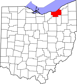
 Location in Cuyahoga County and the state of Ohio | |
| Coordinates: 41°26′59″N 81°39′37″W | |
| Country | United States |
| State | Ohio |
| County | Cuyahoga |
| Government | |
| • Mayor | Trevor Elkins |
| Area | |
| • Total | 0.58 sq mi (1.50 km2) |
| • Land | 0.58 sq mi (1.50 km2) |
| • Water | 0 sq mi (0 km2) |
| Elevation | 692 ft (211 m) |
| Population | |
| • Total | 2,167 |
| • Estimate (2019[4]) | 2,049 |
| • Density | 3,736.2/sq mi (1,442.6/km2) |
| Time zone | UTC-5 (Eastern (EST)) |
| • Summer (DST) | UTC-4 (EDT) |
| ZIP codes | 44105, 44127 |
| Area code(s) | 216 |
| FIPS code | 39-54250[5] |
| GNIS feature ID | 1065145[2] |
Geography
Newburgh Heights is surrounded on three sides (west, north and east) by Washington Park Blvd, north of Harvard Avenue, and west of the Willow Freeway (I-77) at 41°27′N 81°40′W (41.450, -81.660).[6]
According to the United States Census Bureau, the village has a total area of 0.58 square miles (1.50 km2), all land.[1]
Demographics
| Historical population | |||
|---|---|---|---|
| Census | Pop. | %± | |
| 1910 | 940 | — | |
| 1920 | 2,957 | 214.6% | |
| 1930 | 4,152 | 40.4% | |
| 1940 | 3,830 | −7.8% | |
| 1950 | 3,689 | −3.7% | |
| 1960 | 3,512 | −4.8% | |
| 1970 | 3,396 | −3.3% | |
| 1980 | 2,678 | −21.1% | |
| 1990 | 2,310 | −13.7% | |
| 2000 | 2,389 | 3.4% | |
| 2010 | 2,167 | −9.3% | |
| Est. 2019 | 2,049 | [4] | −5.4% |
| U.S. Decennial Census[7] | |||
As of the 2000 census, the center of population in Cuyahoga County was located in Newburgh Heights, near East 26th Street.[8]
96.0% spoke English, 3.4% Polish, and 0.7% Spanish.[9]
2010 census
As of the census[3] of 2010, there were 2,167 people, 958 households, and 536 families residing in the village. The population density was 3,736.2 inhabitants per square mile (1,442.6/km2). There were 1,145 housing units at an average density of 1,974.1 per square mile (762.2/km2). The racial makeup of the village was 79.1% White, 14.9% African American, 0.1% Native American, 0.3% Asian, 2.3% from other races, and 3.2% from two or more races. Hispanic or Latino of any race were 5.4% of the population.
There were 958 households of which 30.7% had children under the age of 18 living with them, 28.7% were married couples living together, 19.1% had a female householder with no husband present, 8.1% had a male householder with no wife present, and 44.1% were non-families. 37.4% of all households were made up of individuals and 10.7% had someone living alone who was 65 years of age or older. The average household size was 2.26 and the average family size was 2.96.
The median age in the village was 37.2 years. 24.8% of residents were under the age of 18; 8.7% were between the ages of 18 and 24; 25.5% were from 25 to 44; 28.4% were from 45 to 64; and 12.6% were 65 years of age or older. The gender makeup of the village was 51.0% male and 49.0% female.
2000 census
As of the census[5] of 2000, there were 2,389 people, 1,052 households, and 621 families residing in the village. The population density was 4,104.3 people per square mile (1,590.3/km²). There were 1,157 housing units at an average density of 1,987.7 per square mile (770.2/km²). The racial makeup of the village was 94.47% White, 3.14% African American, 0.21% Native American, 0.13% Asian, 0.54% from other races, and 1.51% from two or more races. Hispanic or Latino of any race were 2.47% of the population.
There were 1,052 households out of which 25.4% had children under the age of 18 living with them, 36.8% were married couples living together, 17.4% had a female householder with no husband present, and 40.9% were non-families. 33.9% of all households were made up of individuals and 11.8% had someone living alone who was 65 years of age or older. The average household size was 2.27 and the average family size was 2.91.
In the village, the population was spread out with 21.6% under the age of 18, 8.9% from 18 to 24, 33.6% from 25 to 44, 22.4% from 45 to 64, and 13.5% who were 65 years of age or older. The median age was 37 years. For every 100 females there were 93.0 males. For every 100 females age 18 and over, there were 91.4 males.
The median income for a household in the village was $37,409, and the median income for a family was $42,131. Males had a median income of $37,650 versus $24,969 for females. The per capita income for the village was $18,636. About 9.2% of families and 12.0% of the population were below the poverty line, including 16.9% of those under age 18 and 5.3% of those age 65 or over.
Traffic enforcement
Newburgh Heights employs traffic cameras along the short stretch of Interstate 77 that runs through it. These cameras take a picture of the speeding vehicle and the registered owner of the vehicle is mailed a citation after the fact via USPS. The penalties are as follows:
MPH over speed limit and fine
10-19 $150.00
20-29 $200.00
30 or more $300.00
Ohio Supreme Court has ruled three times municipalities are permitted to use cameras. The State of Ohio has restricted municipalities' use of such devices. Newburgh Heights is fully in compliance with Ohio law regarding use of cameras.
The Newburgh Heights Police Department has many unsubstantiated complaints on Facebook for this form of traffic enforcement.[10]
Newburgh Heights Mayor Trevor Elkins said his village issues about 300 speeding tickets per week from using its one hand-held camera. He said the system is safer than when officers pull over speeding drivers, and he disagreed with critics who might say the camera is a cash grab. "The people who are speeding are not victims," Elkins said. "They were breaking the law, and they got caught."[11]
Mayor Elkins has stated publicly that he defends the use of the cameras and admits they generate revenue - a point he is directly quoted as saying he's not sorry about. In a 2016 interview with Cleveland Scene, he stated "We have 120-some-thousand cars traveling through this community every day," he says, "and no matter how aggressive we were, we just couldn't control speeds. This is a safety issue. Now, do I recognize that they generate revenue? Absolutely. Do I apologize for that? No." (Especially, Elkins says, because on I-77, where the speed limit is 60 mph, citations aren't issued until a vehicle hits 74 mph.)"[12]
As of July 3, 2019, Ohio Governor Mike DeWine signed into law legislation that reduces state funding for any city, town, or village operating red light or speed cameras by an amount equivalent to the fines collected. The law also prohibits operation of traffic cameras on interstate highways and requires all appeals of tickets received through camera technology to be heard in court rather than by an administrative officer. Under this new law, Newburgh Heights is no longer be allowed to operate speed cameras on the stretch of Interstate 77 running through it. [13]
References
- "US Gazetteer files 2010". United States Census Bureau. Archived from the original on 2012-01-25. Retrieved 2013-01-06.
- "US Board on Geographic Names". United States Geological Survey. 2007-10-25. Retrieved 2008-01-31.
- "U.S. Census website". United States Census Bureau. Retrieved 2013-01-06.
- "Population and Housing Unit Estimates". Retrieved May 21, 2020.
- "U.S. Census website". United States Census Bureau. Retrieved 2008-01-31.
- "US Gazetteer files: 2010, 2000, and 1990". United States Census Bureau. 2011-02-12. Retrieved 2011-04-23.
- "Census of Population and Housing". Census.gov. Retrieved June 4, 2015.
- County Population Centroids for Ohio
- "Archived copy". Archived from the original on 2013-08-15. Retrieved 2013-08-06.CS1 maint: archived copy as title (link)
- "Newburgh Heights Police Department". Newburgh Heights Police Facebook Page.
- Grzegorek, Vince. "Newburgh Heights Issues 300 Speeding Tickets a Week Via Hand-Held Device". Cleveland Scene. Retrieved 2017-08-26.
- Allard, Sam. "Trevor Elkins". Cleveland Scene. Retrieved 2017-07-20.
- "Cities to Lose Traffic Camera Revenue as Law Takes Effect". U.S. News. July 4, 2019. Archived from the original on 2019-07-05.
External links
Places adjacent to Newburgh Heights, Ohio | ||||||||||
|---|---|---|---|---|---|---|---|---|---|---|
| ||||||||||
Municipalities and communities of Cuyahoga County, Ohio, United States | ||
|---|---|---|
| Cities |
|  Map of Ohio highlighting Cuyahoga County |
| Villages | ||
| Townships | ||
| Footnotes | ‡This populated place also has portions in an adjacent county or counties | |