Bratenahl, Ohio
Bratenahl (/ˈbrætənɑːl/ BRAT-ən-ahl) is a village in Cuyahoga County, Ohio, United States, on the southern coast of Lake Erie. One of Cleveland's oldest suburbs, it is bordered by the city on three sides and by the Lake Erie shoreline to the north. The population was 1,197 at the 2010 census.[6]
Bratenahl, Ohio | |
|---|---|
 Gateway to a Lakeshore Boulevard estate | |
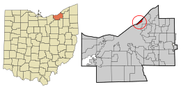 Location in Cuyahoga County and the state of Ohio. | |
.svg.png) Location of Ohio in the United States | |
| Coordinates: 41°33′15″N 81°36′16″W | |
| Country | United States |
| State | Ohio |
| County | Cuyahoga |
| Government | |
| • Type | Mayor-council |
| • Mayor | John Licastro |
| • Council President | Jim Puffenberger |
| Area | |
| • Total | 1.60 sq mi (4.14 km2) |
| • Land | 1.02 sq mi (2.64 km2) |
| • Water | 0.58 sq mi (1.50 km2) |
| Elevation | 614 ft (187 m) |
| Population | |
| • Total | 1,197 |
| • Estimate (2019[4]) | 1,159 |
| • Density | 1,173.5/sq mi (453.1/km2) |
| Time zone | UTC-5 (Eastern (EST)) |
| • Summer (DST) | UTC-4 (EDT) |
| ZIP code | 44108 & 44110 |
| Area code(s) | 216 |
| FIPS code | 39-08336[5] |
| GNIS feature ID | 1048543[2] |
History
Incorporated in 1903, Bratenahl is one of the older residential suburbs of Cleveland along with Shaker Heights, Lakewood, and Cleveland Heights; of these, Bratenahl has the highest per capita wealth. Bratenahl is a small community of fewer than 1,200 population inhabiting approximately 700 households, some of which are stately estates, townhouses, and condominiums on the lakefront.[7] Its famous Lake Shore Boulevard has been featured in many magazines including Better Homes and Gardens.
Bratenahl is home to a once controversial luxury high-rise condominium complex named Bratenahl Place.[7] Though many residents opposed it at the time, in 1967 two large multi-occupancy buildings of brutalist architectural design were built on the lakefront. One of the two structures was originally intended to be a 180-unit rental apartment building, while the other, smaller one was a condominium from its inception. In 1976 however, the larger one also became a condominium.
Geography
Bratenahl is located at 41°33′15″N 81°36′16″W (41.554275, −81.604574).[8]
According to the United States Census Bureau, the village has a total area of 1.60 square miles (4.14 km2), of which 1.02 square miles (2.64 km2) is land and 0.58 square miles (1.50 km2) is water.[1]
Demographics
| Historical population | |||
|---|---|---|---|
| Census | Pop. | %± | |
| 1910 | 690 | — | |
| 1920 | 1,000 | 44.9% | |
| 1930 | 1,308 | 30.8% | |
| 1940 | 1,350 | 3.2% | |
| 1950 | 1,240 | −8.1% | |
| 1960 | 1,332 | 7.4% | |
| 1970 | 1,613 | 21.1% | |
| 1980 | 1,485 | −7.9% | |
| 1990 | 1,356 | −8.7% | |
| 2000 | 1,337 | −1.4% | |
| 2010 | 1,197 | −10.5% | |
| Est. 2019 | 1,159 | [4] | −3.2% |
| Sources:[5][9][10][11][12][13][14][15] | |||
2010 census
As of the census[3] of 2010, there were 1,197 people, 679 households, and 333 families living in the village. The population density was 1,173.5 inhabitants per square mile (453.1/km2). There were 811 housing units at an average density of 795.1 per square mile (307.0/km2). The racial makeup of the village was 80.5% White, 15.5% African American, 0.3% Native American, 2.5% Asian, 0.3% from other races, and 0.9% from two or more races. Hispanic or Latino of any race were 0.9% of the population.
There were 679 households, of which 7.4% had children under the age of 18 living with them, 42.1% were married couples living together, 5.3% had a female householder with no husband present, 1.6% had a male householder with no wife present, and 51.0% were non-families. 42.7% of all households were made up of individuals, and 16% had someone living alone who was 65 years of age or older. The average household size was 1.75 and the average family size was 2.32.
The median age in the village was 57.8 years. 6.5% of residents were under the age of 18; 4% were between the ages of 18 and 24; 16.4% were from 25 to 44; 42.2% were from 45 to 64; and 31.1% were 65 years of age or older. The gender makeup of the village was 48.6% male and 51.4% female.
Of the village's population over the age of 25, 62.4% hold a bachelor's degree or higher.[16]
2000 census
As of the census[5] of 2000, there were 1,337 people, 711 households, and 363 families living in the village. The population density was 1,304.1 people per square mile (501.2/km2). There were 800 housing units at an average density of 780.3 per square mile (299.9/km2). The racial makeup of the village was 86.82% White, 10.34% African American, 0.07% Native American, 0.75% Asian, 0.22% from other races, and 1.80% from two or more races. Hispanic or Latino of any race were 1.12% of the population.
There were 711 households, out of which 11.8% had children under the age of 18 living with them, 43.7% were married couples living together, 5.5% had a female householder with no husband present, and 48.9% were non-families. 40.9% of all households were made up of individuals, and 15.9% had someone living alone who was 65 years of age or older. The average household size was 1.87 and the average family size was 2.50.
In the village, the population was spread out, with 11.4% under the age of 18, 3.4% from 18 to 24, 21.8% from 25 to 44, 36.2% from 45 to 64, and 27.2% who were 65 years of age or older. The median age was 51 years. For every 100 females there were 93.2 males. For every 100 females age 18 and over, there were 90.8 males.
The median income for a household in the village was $76,028, and the median income for a family was $104,987. Males had a median income of $61,250 versus $46,563 for females. The per capita income for the village was $72,757. About 1.6% of families and 4.3% of the population were below the poverty line, including 4.1% of those under the age of 18 and 2.7% of those ages 65 or older.
Notable people
- Jim Backus, actor and comedian[17]
- Richard Fleischman, architect[18]
- Eliot Ness, law enforcement agent[19]
References
- "US Gazetteer files 2010". United States Census Bureau. Archived from the original on 2012-01-25. Retrieved 2013-01-06.
- "US Board on Geographic Names". United States Geological Survey. 2007-10-25. Retrieved 2008-01-31.
- "U.S. Census website". United States Census Bureau. Retrieved 2013-01-06.
- "Population and Housing Unit Estimates". Retrieved May 21, 2020.
- "U.S. Census website". United States Census Bureau. Retrieved 2008-01-31.
- "Profile of General Population and Housing Characteristics: 2010 Demographic Profile Data (DP-1): Bratenahl village, Ohio". United States Census Bureau. Retrieved November 22, 2011.
- "Bratenahl". The Encyclopedia of Cleveland History. Case Western Reserve University. Retrieved June 9, 2020.
- "US Gazetteer files: 2010, 2000, and 1990". United States Census Bureau. 2011-02-12. Retrieved 2011-04-23.
- "Population of Civil Divisions Less than Counties" (PDF). Statistics of the Population of the United States at the Ninth Census. U.S. Census Bureau. 1870. Retrieved 24 April 2020.
- "Population of Civil Divisions Less than Counties" (PDF). Statistics of the Population of the United States at the Tenth Census. U.S. Census Bureau. 1880. Retrieved 28 November 2013.
- "Population: Ohio" (PDF). 1910 U.S. Census. U.S. Census Bureau. Retrieved 28 November 2013.
- "Population: Ohio" (PDF). 1930 US Census. U.S. Census Bureau. Retrieved 28 November 2013.
- "Number of Inhabitants: Ohio" (PDF). 18th Census of the United States. U.S. Census Bureau. 1960. Retrieved 24 April 2020.
- "Ohio: Population and Housing Unit Counts" (PDF). U.S. Census Bureau. Retrieved 22 November 2013.
- "Incorporated Places and Minor Civil Divisions Datasets: Subcounty Population Estimates: April 1, 2010 to July 1, 2012". U.S. Census Bureau. Archived from the original on 11 June 2013. Retrieved 25 November 2013.
- United States Census
- "Jim Backus". Bratenahl Historical Society. Retrieved June 9, 2020.
- Bullard, Stan (July 23, 2007). "Helen Moss and Richard Fleischman". Crain's Cleveland Business. Retrieved June 9, 2020.
- "Eliot Ness". Bratenahl Historical Society. Retrieved June 9, 2020.
External links
Municipalities and communities of Cuyahoga County, Ohio, United States | ||
|---|---|---|
| Cities |
| 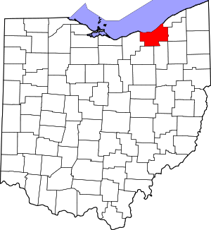 Map of Ohio highlighting Cuyahoga County |
| Villages | ||
| Townships | ||
| Footnotes | ‡This populated place also has portions in an adjacent county or counties | |
| Authority control |
|
|---|