National Register of Historic Places listings in Ward County, North Dakota
This is a list of the National Register of Historic Places listings in Ward County, North Dakota.
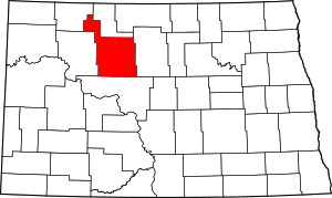
Location of Ward County in North Dakota
This is intended to be a complete list of the properties and districts on the National Register of Historic Places in Ward County, North Dakota, United States. The locations of National Register properties and districts for which the latitude and longitude coordinates are included below, may be seen in a map.[1]
There are 15 properties and districts listed on the National Register in the county.
| Adams | Barnes | Benson | Billings | Bottineau | Bowman | Burke | Burleigh | Cass | Cavalier | Dickey | Divide | Dunn | Eddy | Emmons | Foster | Golden Valley | Grand Forks | Grant | Griggs | Hettinger | Kidder | La Moure | Logan | McHenry | McIntosh | McKenzie | McLean | Mercer | Morton | Mountrail | Nelson | Oliver | Pembina | Pierce | Ramsey | Ransom | Renville | Richland | Rolette | Sargent | Sheridan | Sioux | Slope | Stark | Steele | Stutsman | Towner | Traill | Walsh | Ward | Wells | Williams |
- This National Park Service list is complete through NPS recent listings posted June 19, 2020.[2]
Current listings
| [3] | Name on the Register | Image | Date listed[4] | Location | City or town | Description |
|---|---|---|---|---|---|---|
| 1 | Andrew Carr, Sr. House | 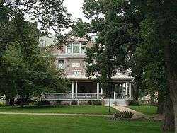 Andrew Carr, Sr. House |
April 26, 1984 (#84002771) |
510 4th Ave., NW. 48°14′25″N 101°18′06″W |
Minot | |
| 2 | Eastwood Park Bridge | 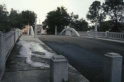 Eastwood Park Bridge |
April 21, 1975 (#75001307) |
Central Ave. and 6th St., SE. 48°14′10″N 101°17′03″W |
Minot | North Dakota's only false arch bridge |
| 3 | Eastwood Park Historic District |  Eastwood Park Historic District |
October 16, 1986 (#86002824) |
Bounded by Old Souris Oxbow 48°14′06″N 101°16′50″W |
Minot | |
| 4 | Levi Glick Round Barn | March 25, 1987 (#86002760) |
ND 38 48°13′29″N 101°10′20″W |
Surrey | ||
| 5 | Minot Carnegie Library |  Minot Carnegie Library |
November 10, 1980 (#80002929) |
105 2nd Ave., SE. 48°14′05″N 101°17′27″W |
Minot | |
| 6 | Minot Commercial Historic District | 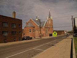 Minot Commercial Historic District |
October 16, 1980 (#86002823) |
Roughly bounded by Soo Line railroad line, and Burdick Expressway, and Broadway 48°14′02″N 101°18′02″W |
Minot | |
| 7 | Minot Industrial Historic District | 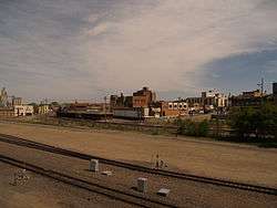 Minot Industrial Historic District |
October 16, 1986 (#86002818) |
Roughly bounded by the Souris River, 5th St., NE., 1st Ave., SE., 1st St., NE., Soo Line railroad line, and Broadway 48°14′19″N 101°17′17″W |
Minot | |
| 8 | Our Savior's Scandinavian Lutheran Church | February 15, 2005 (#05000060) |
1 mile north of ND 50 and 0.25 miles west of Ward County Road 1 48°33′42″N 102°07′44″W |
near Coulee | ||
| 9 | Soo Line Passenger Depot | 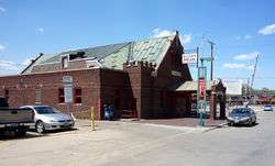 Soo Line Passenger Depot |
January 20, 1978 (#78001996) |
11 N. Main St. 48°14′13″N 101°17′34″W |
Minot | |
| 10 | South Prairie Community Hall | June 7, 2006 (#06000474) |
177th Ave., SW. 48°03′17″N 101°17′57″W |
Minot | ||
| 11 | Tufveson House | 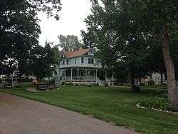 Tufveson House |
April 12, 1984 (#84002773) |
426 4th Ave., NW. 48°14′26″N 101°18′05″W |
Minot | |
| 12 | U.S. Post Office-Minot | 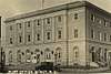 U.S. Post Office-Minot |
October 14, 1980 (#80002930) |
100 1st St., SW. 48°14′04″N 101°17′36″W |
Minot | |
| 13 | Union National Bank and Annex |  Union National Bank and Annex |
January 27, 1983 (#83001941) |
2 N. Main and 7-11 E. Central Ave. 48°14′12″N 101°17′32″W |
Minot | |
| 14 | Ward County Courthouse | 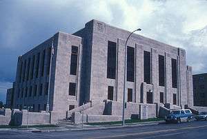 Ward County Courthouse |
November 14, 1985 (#85002997) |
315 3rd St., SE. 48°13′59″N 101°17′15″W |
Minot | |
| 15 | Westland Oil Filling Station | 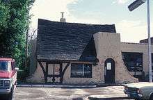 Westland Oil Filling Station |
February 27, 1987 (#86002816) |
510 E. Central Ave. 48°14′11″N 101°17′05″W |
Minot |
See also
| Wikimedia Commons has media related to National Register of Historic Places in Ward County, North Dakota. |
References
- The latitude and longitude information provided in this table was derived originally from the National Register Information System, which has been found to be fairly accurate for about 99% of listings. Some locations in this table may have been corrected to current GPS standards.
- "National Register of Historic Places: Weekly List Actions". National Park Service, United States Department of the Interior. Retrieved on June 19, 2020.
- Numbers represent an ordering by significant words. Various colorings, defined here, differentiate National Historic Landmarks and historic districts from other NRHP buildings, structures, sites or objects.
- The eight-digit number below each date is the number assigned to each location in the National Register Information System database, which can be viewed by clicking the number.
| Topics | |
|---|---|
| Lists by state |
|
| Lists by insular areas | |
| Lists by associated state | |
| Other areas | |
| Related | |
| |
Municipalities and communities of Ward County, North Dakota, United States | ||
|---|---|---|
| Cities | Map of North Dakota highlighting Ward County | |
| Townships |
| |
| CDPs | ||
| Unincorporated communities |
| |
This article is issued from Wikipedia. The text is licensed under Creative Commons - Attribution - Sharealike. Additional terms may apply for the media files.