National Register of Historic Places listings in St. Landry Parish, Louisiana
This is a list of the National Register of Historic Places listings in St. Landry Parish, Louisiana.
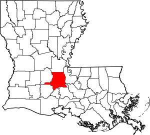
Location of St. Landry Parish in Louisiana
This is intended to be a complete list of the properties and districts on the National Register of Historic Places in St. Landry Parish, Louisiana, United States. The locations of National Register properties and districts for which the latitude and longitude coordinates are included below, may be seen in a map.[1]
There are 36 properties and districts listed on the National Register in the parish. Another property was once listed but has been removed.
- This National Park Service list is complete through NPS recent listings posted June 19, 2020.[2]
Current listings
| [3] | Name on the Register[4] | Image | Date listed[5] | Location | City or town | Description |
|---|---|---|---|---|---|---|
| 1 | Academy of the Sacred Heart | 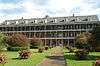 Academy of the Sacred Heart |
February 18, 1975 (#75002079) |
Northeast of Grand Coteau 30°25′51″N 92°02′14″W |
Grand Coteau | |
| 2 | Arlington Plantation House | August 11, 1982 (#82004676) |
North of Washington off Louisiana Highway 103 30°38′48″N 92°04′19″W |
Washington | ||
| 3 | Burleigh House | August 11, 1982 (#82004673) |
Burleigh Lane 30°24′44″N 92°02′54″W |
Grand Coteau | ||
| 4 | Chretien Point Plantation | 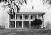 Chretien Point Plantation |
May 26, 1977 (#77001519) |
2 miles southwest of Sunset on Blue Spring Rd. 30°23′26″N 92°05′55″W |
Sunset | |
| 5 | Martin Donato House | 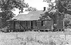 Martin Donato House |
April 27, 2005 (#05000345) |
8343 U.S. Route 182 30°33′14″N 92°04′03″W |
Opelousas | |
| 6 | Edward Benjamin Dubuisson House | 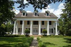 Edward Benjamin Dubuisson House |
February 14, 1997 (#97000059) |
437 N. Court St. 30°32′16″N 92°04′58″W |
Opelousas | |
| 7 | Alexandre Fontenot fils House | October 22, 1982 (#82000453) |
South of Grand Prairie off Louisiana Highway 103 30°40′31″N 92°08′31″W |
Grand Prairie | ||
| 8 | Frozard Plantation House | August 12, 1982 (#82004674) |
South of Grand Coteau off Louisiana Highway 93 30°24′37″N 91°59′57″W |
Grand Coteau | ||
| 9 | Grand Coteau Historic District | November 25, 1980 (#80004320) |
Louisiana Highway 93 30°25′39″N 92°02′24″W |
Grand Coteau | ||
| 10 | Homeplace | October 8, 1980 (#80004321) |
North of Washington on Louisiana Highway 182 30°40′44″N 92°03′27″W |
Washington | ||
| 11 | Labyche-Estorge House | 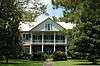 Labyche-Estorge House |
October 5, 1982 (#82000454) |
427 N. Market St. 30°32′15″N 92°05′05″W |
Opelousas | |
| 12 | LaFleur House | March 5, 1998 (#98000179) |
753 Louisiana Highway 748 30°40′46″N 92°09′22″W |
Grand Prairie | ||
| 13 | Dominique LaLanne House and Store | August 3, 1976 (#76002166) |
Southwestern corner of Bridge and Dejean Sts. 30°36′53″N 92°03′21″W |
Washington | ||
| 14 | Lamorandier-Prudhomme-Jackson House | 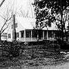 Lamorandier-Prudhomme-Jackson House |
December 22, 1983 (#83003635) |
Off U.S. Route 167 30°35′04″N 92°03′41″W |
Opelousas | |
| 15 | John Lewis House | April 22, 1991 (#91000418) |
Address Restricted |
Opelousas | ||
| 16 | Liberty Theatre | 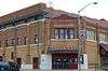 Liberty Theatre |
February 19, 1987 (#87000177) |
200 W. Park Ave. 30°29′35″N 92°24′58″W |
Eunice | |
| 17 | Midland Branch Railroad Depot | 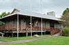 Midland Branch Railroad Depot |
September 27, 1983 (#83000538) |
1st and North Sts. 30°29′37″N 92°24′54″W |
Eunice | |
| 18 | Montet House | April 12, 2006 (#06000244) |
157 Shady Ln. 30°21′56″N 92°02′03″W |
Arnaudville | ||
| 19 | Moundville Plantation House | 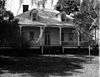 Moundville Plantation House |
December 12, 1976 (#76002167) |
2.5 miles northwest of Washington off Louisiana Highway 103 30°38′37″N 92°04′20″W |
Washington | |
| 20 | Mouton House |  Mouton House |
August 9, 1991 (#91001045) |
261 N. Liberty St. 30°32′10″N 92°05′12″W |
Opelousas | Destroyed due to arson in July 2016.[6] |
| 21 | Old Federal Building | 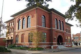 Old Federal Building |
December 28, 1982 (#82000455) |
162 S. Court St. 30°31′58″N 92°04′58″W |
Opelousas | |
| 22 | Opelousas City Hall | 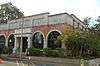 Opelousas City Hall |
September 8, 1987 (#87001470) |
Junction of Market and Bellevue Sts. at Courthouse Sq. 30°32′02″N 92°05′02″W |
Opelousas | |
| 23 | Opelousas Historic District | 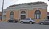 Opelousas Historic District |
June 2, 1989 (#89000477) |
Roughly bounded by Bellevue, Court St., Landry St., and Market St. 30°32′01″N 92°05′00″W |
Opelousas | |
| 24 | Plaisance School | 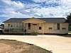 Plaisance School |
August 23, 2004 (#04000080) |
3264 Louisiana Highway 167 30°37′07″N 92°07′57″W |
Plaisance | Built in 1921, only known Rosenwald School in Louisiana still used for education. [7] |
| 25 | Poiret Place |  Poiret Place |
April 7, 1983 (#83000539) |
Northwest of Opelousas off Louisiana Highway 167 30°37′34″N 92°07′53″W |
Opelousas | |
| 26 | Michel Prudhomme House | 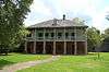 Michel Prudhomme House |
May 24, 1977 (#77001518) |
1152 Prudhomme Circle 30°32′39″N 92°04′35″W |
Opelousas | |
| 27 | Ray Homestead | 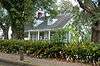 Ray Homestead |
November 28, 1990 (#90001758) |
378 W. Bellevue St. 30°32′05″N 92°05′10″W |
Opelousas | |
| 28 | Robin House and Barn | 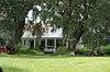 Robin House and Barn |
August 27, 1999 (#99001036) |
1616 Louisiana Highway 31 30°26′54″N 91°55′24″W |
Arnaudville | |
| 29 | St. Landry Catholic Church | 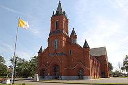 St. Landry Catholic Church |
May 3, 1982 (#82004675) |
900 N. Union St. 30°32′34″N 92°04′45″W |
Opelousas | |
| 30 | St. Landry Lumber Company | 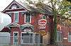 St. Landry Lumber Company |
August 7, 1989 (#89001044) |
215 N. Railroad Ave. 30°32′08″N 92°05′16″W |
Opelousas | |
| 31 | Starvation Point | May 15, 1980 (#80004323) |
North of Washington off Louisiana Highways 10/132 30°39′01″N 92°03′48″W |
Washington | ||
| 32 | Sunset High School | 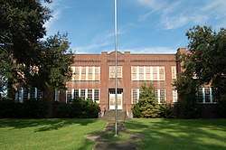 Sunset High School |
May 12, 1999 (#99000556) |
223 Marie St. 30°24′47″N 92°03′54″W |
Sunset | |
| 33 | Venus House | 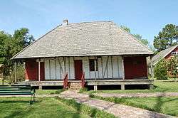 Venus House |
April 22, 1991 (#91000419) |
Junction of U.S. Route 190 and Academy St. 30°31′52″N 92°04′29″W |
Opelousas | |
| 34 | Washington Historic District | November 15, 1978 (#78003114) |
Louisiana Highway 182 30°36′54″N 92°03′33″W |
Washington | ||
| 35 | White's Chapel United Methodist Church | 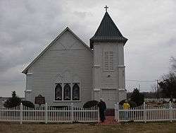 White's Chapel United Methodist Church |
April 5, 1983 (#83000540) |
South of Bunkie off Louisiana Highway 29 30°50′01″N 92°12′12″W |
Bunkie | |
| 36 | Wier House | 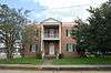 Wier House |
April 7, 1995 (#95000368) |
310 E. Bellevue St. 30°32′03″N 92°04′52″W |
Opelousas |
Former listings
| [3] | Name on the Register | Image | Date listed | Date removed | Location | City or town | Summary |
|---|---|---|---|---|---|---|---|
| 1 | Jacques Dupre House | April 12, 1990 (#90000543) | December 5, 2003 | Off US 167, N of Opelousas |
Opelousas vicinity | ||
| 2 | MacLand Plantation House | October 8, 1980 (#80004322) | March 24, 2006 | 3.4 mi N of Washington on LA 10 |
Washington vicinity |
See also
| Wikimedia Commons has media related to National Register of Historic Places in Saint Landry Parish, Louisiana. |
References
- The latitude and longitude information provided in this table was derived originally from the National Register Information System, which has been found to be fairly accurate for about 99% of listings. Some locations in this table may have been corrected to current GPS standards.
- "National Register of Historic Places: Weekly List Actions". National Park Service, United States Department of the Interior. Retrieved on June 19, 2020.
- Numbers represent an ordering by significant words. Various colorings, defined here, differentiate National Historic Landmarks and historic districts from other NRHP buildings, structures, sites or objects.
- "National Register Information System". National Register of Historic Places. National Park Service. March 13, 2009.
- The eight-digit number below each date is the number assigned to each location in the National Register Information System database, which can be viewed by clicking the number.
- https://www.theadvocate.com/acadiana/news/article_5da43a96-49d8-11e6-8b1b-bbdcc4e277f1.html
- Historical Marker located at school https://www.hmdb.org/marker.asp?marker=107477
| Topics | |
|---|---|
| Lists by state |
|
| Lists by insular areas | |
| Lists by associated state | |
| Other areas | |
| Related | |
| |
Municipalities and communities of St. Landry Parish, Louisiana, United States | ||
|---|---|---|
Parish seat: Opelousas | ||
| Cities | | |
| Towns | ||
| Villages | ||
| CDP | ||
| Other unincorporated communities |
| |
| Footnotes | ‡This populated place also has portions in an adjacent parish or parishes | |
This article is issued from Wikipedia. The text is licensed under Creative Commons - Attribution - Sharealike. Additional terms may apply for the media files.