National Register of Historic Places listings in Petrified Forest National Park
This is a list of the National Register of Historic Places listings in Petrified Forest National Park.
This is intended to be a complete list of the properties and districts on the National Register of Historic Places in Petrified Forest National Park, Arizona, United States. The locations of National Register properties and districts for which the latitude and longitude coordinates are included below, may be seen in a Google map.[1]
There are nine properties and districts listed on the National Register in the park, one of which is a National Historic Landmark.[2]
- This National Park Service list is complete through NPS recent listings posted June 19, 2020.[3]
Current listings
| [4] | Name on the Register | Image | Date listed[5] | Location | City or town | Description |
|---|---|---|---|---|---|---|
| 1 | Agate House Pueblo | 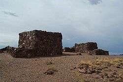 Agate House Pueblo |
October 6, 1975 (#75000170) |
Petrified Forest National Park 34°48′18″N 109°51′40″W |
Holbrook | |
| 2 | Flattop Site | July 12, 1976 (#76000214) |
Address restricted |
Adamana | ||
| 3 | Newspaper Rock Petroglyphs Archeological District | 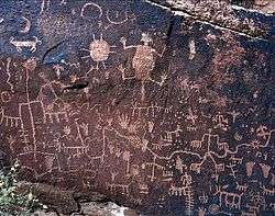 Newspaper Rock Petroglyphs Archeological District |
July 12, 1976 (#76000185) |
Address restricted 34°57′43″N 109°47′57″W |
Adamana | |
| 4 | Painted Desert Community Complex Historic District |  Painted Desert Community Complex Historic District |
April 15, 2005 (#05000284) |
One Park Rd. 35°04′06″N 109°46′50″W |
Petrified Forest National Park | |
| 5 | Painted Desert Inn | 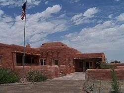 Painted Desert Inn |
October 10, 1975 (#87001421) |
West of Navajo in Petrified Forest National Park, off Interstate 40 35°05′03″N 109°47′06″W |
Navajo | Designated a National Historic Landmark on May 28, 1987 |
| 6 | Painted Desert Petroglyphs and Ruins Archeological District |  Painted Desert Petroglyphs and Ruins Archeological District |
June 24, 1976 (#76000215) |
Address Restricted |
Holbrook | |
| 7 | Puerco Ruin and Petroglyphs |  Puerco Ruin and Petroglyphs |
July 12, 1976 (#76000208) |
Address restricted 34°58′29″N 109°47′39″W |
Adamana | |
| 8 | Thirty-Fifth Parallel Route | December 6, 1977 (#77000129) |
25 miles east of Holbrook off Interstate 40 35°04′09″N 109°46′14″W |
Holbrook | ||
| 9 | Twin Buttes Archeological District | July 12, 1976 (#76000952) |
Address restricted |
Adamana |
Former listing
| [4] | Name on the Register | Image | Date listed/removed | Location | City or town | Summary |
|---|---|---|---|---|---|---|
| 1 | Petrified Forest Bridge | November 27, 1998 (#88001616) |
Petrified Forest Park Rd. over Rio Puerco |
Navajo vicinity | Vehicular Bridges in Arizona MPS |
See also
| Wikimedia Commons has media related to National Register of Historic Places in Petrified Forest National Park. |
References
- The latitude and longitude information provided in this table was derived originally from the National Register Information System, which has been found to be fairly accurate for about 99% of listings. Some locations in this table may have been corrected to current GPS standards.
- "Petrified Forest: Places". National Park Service. Retrieved September 23, 2013.
- "National Register of Historic Places: Weekly List Actions". National Park Service, United States Department of the Interior. Retrieved on June 19, 2020.
- Numbers represent an ordering by significant words. Various colorings, defined here, differentiate National Historic Landmarks and historic districts from other NRHP buildings, structures, sites or objects.
- The eight-digit number below each date is the number assigned to each location in the National Register Information System database, which can be viewed by clicking the number.
| Topics | |
|---|---|
| Lists by state |
|
| Lists by insular areas | |
| Lists by associated state | |
| Other areas | |
| Related | |
| |
This article is issued from Wikipedia. The text is licensed under Creative Commons - Attribution - Sharealike. Additional terms may apply for the media files.