National Register of Historic Places listings in Mayes County, Oklahoma
This is a list of the National Register of Historic Places listings in Mayes County, Oklahoma.
Location of Mayes County in Oklahoma
This is intended to be a complete list of the properties and districts on the National Register of Historic Places in Mayes County, Oklahoma, United States. The locations of National Register properties and districts for which the latitude and longitude coordinates are included below, may be seen in a map.[1]
There are 6 properties and districts listed on the National Register in the county.
- This National Park Service list is complete through NPS recent listings posted June 19, 2020.[2]
Current listings
| [3] | Name on the Register[4] | Image | Date listed[5] | Location | City or town | Description |
|---|---|---|---|---|---|---|
| 1 | Cabin Creek Battlefield | July 27, 1971 (#71000669) |
3 miles north of Pensacola 36°29′04″N 95°07′16″W |
Pensacola | ||
| 2 | Farmers and Merchants Bank | July 14, 1983 (#83002091) |
201 W. Main St. 36°10′41″N 95°20′45″W |
Chouteau | ||
| 3 | Lewis Ross/Cherokee Orphan Asylum Springhouse | August 18, 1983 (#83002092) |
Off State Highway 20 36°17′30″N 95°08′59″W |
Salina | ||
| 4 | Pensacola Dam | 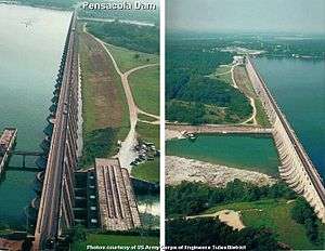 Pensacola Dam |
September 2, 2003 (#03000883) |
State Highway 28 over the Grand River, 0.5 miles east of its junction with State Highway 82 36°28′18″N 95°02′02″W |
Langley | |
| 5 | Territorial Commercial District | September 22, 1983 (#83002093) |
Main St. 36°11′12″N 95°20′41″W |
Chouteau | ||
| 6 | Union Mission Site | September 10, 1971 (#71000668) |
About 5 miles northeast of Mazie 36°07′34″N 95°17′09″W |
Mazie |
See also
References
- The latitude and longitude information provided in this table was derived originally from the National Register Information System, which has been found to be fairly accurate for about 99% of listings. Some locations in this table may have been corrected to current GPS standards.
- "National Register of Historic Places: Weekly List Actions". National Park Service, United States Department of the Interior. Retrieved on June 19, 2020.
- Numbers represent an ordering by significant words. Various colorings, defined here, differentiate National Historic Landmarks and historic districts from other NRHP buildings, structures, sites or objects.
- "National Register Information System". National Register of Historic Places. National Park Service. March 13, 2009.
- The eight-digit number below each date is the number assigned to each location in the National Register Information System database, which can be viewed by clicking the number.
| Topics | |
|---|---|
| Lists by state |
|
| Lists by insular areas | |
| Lists by associated state | |
| Other areas | |
| Related | |
| |
Municipalities and communities of Mayes County, Oklahoma, United States | ||
|---|---|---|
| City | Mayes County map | |
| Towns | ||
| CDPs | ||
| Unincorporated communities |
| |
| Footnotes | ‡This populated place also has portions in an adjacent county or counties | |
This article is issued from Wikipedia. The text is licensed under Creative Commons - Attribution - Sharealike. Additional terms may apply for the media files.