National Register of Historic Places listings in Glacier County, Montana
This is a list of the National Register of Historic Places listings in Glacier County, Montana. It is intended to be a complete list of the properties and districts on the National Register of Historic Places in Glacier County, Montana, United States. The locations of National Register properties and districts for which the latitude and longitude coordinates are included below, may be seen in a map.[1]
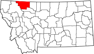
Location of Glacier County in Montana
There are 37 properties and districts listed on the National Register in the county, including 3 National Historic Landmarks.
- This National Park Service list is complete through NPS recent listings posted June 19, 2020.[2]
Listings county-wide
| [3] | Name on the Register | Image | Date listed[4] | Location | City or town | Description |
|---|---|---|---|---|---|---|
| 1 | Babb-Piegan, Montana, Inspection Station | 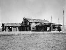 Babb-Piegan, Montana, Inspection Station |
April 12, 2006 (#06000252) |
U.S. Route 89 near the Canada–US border 48°59′35″N 113°22′47″W |
Babb | The 1930s former border station, a log building about 1/4 mile south of current border station. |
| 2 | Camp Disappointment | 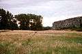 Camp Disappointment |
October 15, 1966 (#66000434) |
12 miles northeast of Browning 48°40′11″N 112°48′27″W |
Browning | |
| 3 | Chief Mountain Border Station and Quarters | 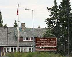 Chief Mountain Border Station and Quarters |
May 20, 2008 (#06000744) |
Montana Highway 17 at the Canada–US border in Glacier National Park 48°59′48″N 113°39′37″W |
Babb | |
| 4 | Cut Bank Municipal Airport and Army Air Force Base | 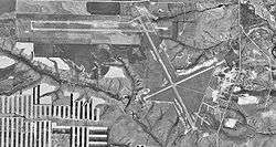 Cut Bank Municipal Airport and Army Air Force Base |
January 29, 2008 (#07001494) |
Valier Highway 48°36′27″N 112°21′59″W |
Cut Bank | |
| 5 | Cut Bank Ranger Station Historic District | 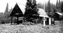 Cut Bank Ranger Station Historic District |
January 19, 1996 (#95001566) |
Northern side of Cut Bank Creek in Glacier National Park 48°36′22″N 113°22′34″W |
East Glacier | |
| 6 | East Glacier Ranger Station Historic District | 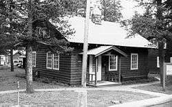 East Glacier Ranger Station Historic District |
December 16, 1986 (#86003696) |
0.75 miles (1.21 km) north of East Glacier Park on Montana Highway 49 48°26′51″N 113°13′25″W |
East Glacier | part of the Glacier National Park MRA |
| 7 | Glacier County Courthouse | 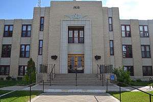 Glacier County Courthouse |
June 25, 2013 (#13000446) |
512 East Main Street 48°37′57″N 112°19′35″W |
Cut Bank | |
| 8 | Glacier National Park Tourist Trails-Inside Trail, South Circle, North Circle | 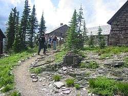 Glacier National Park Tourist Trails-Inside Trail, South Circle, North Circle |
January 19, 1996 (#95001579) |
Inside Trail, South Circle and North Circle Trails 48°41′41″N 113°33′46″W |
St. Mary | |
| 9 | Glacier Park Women's Club | June 13, 2019 (#100004092) |
SE Corner of US Highway 2 and Glacier Ave. 48°26′34″N 113°13′05″W |
East Glacier Park Village | ||
| 10 | Goathaunt Bunkhouse | 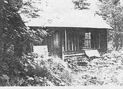 Goathaunt Bunkhouse |
January 19, 1996 (#95001568) |
Southern end of Waterton Lake in Glacier National Park 48°57′39″N 113°53′53″W |
St. Mary | |
| 11 | Going-to-the-Sun Road | 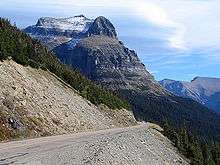 Going-to-the-Sun Road |
June 16, 1983 (#83001070) |
Glacier Route 1 48°38′48″N 113°46′48″W |
West Glacier | Extends into Flathead County |
| 12 | Great Northern Railway Buildings |  Great Northern Railway Buildings |
May 28, 1987 (#87001453) |
Glacier National Park 48°38′29″N 113°32′17″W |
Glacier National Park | |
| 13 | Holy Family Mission | 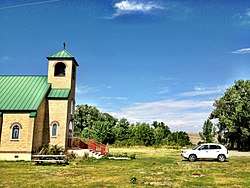 Holy Family Mission |
June 14, 1982 (#82003170) |
East of Browning 48°28′55″N 112°44′24″W |
Browning | |
| 14 | Kootenai Creek Snowshoe Cabin | 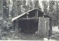 Kootenai Creek Snowshoe Cabin |
July 1, 1999 (#99000775) |
Flattop Mountain along Kootenai Creek 48°51′55″N 113°54′28″W |
St. Mary | |
| 15 | Lee Creek Snowshoe Cabin |  Lee Creek Snowshoe Cabin |
March 2, 2001 (#01000203) |
Northeastern corner of Glacier National Park 48°59′10″N 113°37′20″W |
Glacier National Park | |
| 16 | Little Chief (boat) |  Little Chief (boat) |
December 14, 2017 (#100001897) |
Two Medicine Lake, Glacier National Park 48°41′27″N 113°31′30″W |
East Glacier Park vicinity | Duplicate listing for Rising Wolf, below. |
| 17 | Logan Pass Visitor Center | 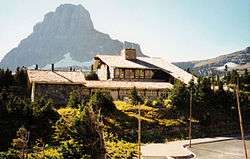 Logan Pass Visitor Center |
April 15, 2008 (#08000334) |
Going-to-the-Sun Rd., 18 miles west of U.S. Route 89 48°41′43″N 113°43′04″W |
St. Mary | |
| 18 | Many Glacier Barn and Bunkhouse | 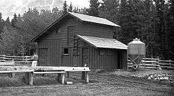 Many Glacier Barn and Bunkhouse |
January 19, 1996 (#95001570) |
Glacier Route 3 at Apikuni Flat in Glacier National Park 48°48′04″N 113°38′33″W |
St. Mary | |
| 19 | Many Glacier Campground Camptender's Cabin |  Many Glacier Campground Camptender's Cabin |
January 19, 1996 (#95001571) |
Many Glacier in Glacier National Park 48°47′49″N 113°40′37″W |
St. Mary | |
| 20 | Many Glacier Hotel Historic District | 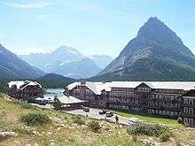 Many Glacier Hotel Historic District |
January 19, 1996 (#76000173) |
West of Babb 48°47′54″N 113°39′12″W |
Babb | |
| 21 | Morning Eagle (carvel-planked wooden vessel) | _-_panoramio.jpg) Morning Eagle (carvel-planked wooden vessel) |
July 23, 2018 (#100002691) |
Josephine L., Glacier NP 48°47′15″N 113°40′10″W |
Babb | part of the Glacier National Park MRA |
| 22 | Pass Creek Snowshoe Cabin | 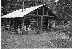 Pass Creek Snowshoe Cabin |
December 19, 1986 (#86003689) |
Confluence of the Waterton River and Pass Creek 48°53′47″N 113°54′23″W |
Babb | part of the Glacier National Park MRA |
| 23 | Ptarmigan Tunnel | 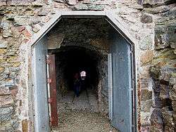 Ptarmigan Tunnel |
February 14, 1986 (#86000360) |
North of Ptarmigan Lake 48°51′13″N 113°42′24″W |
Babb | part of the Glacier National Park MRA |
| 24 | Rising Sun Auto Camp |  Rising Sun Auto Camp |
January 19, 1996 (#95001574) |
500 feet north of Going-to-the-Sun Rd. at St. Mary Lake in Glacier National Park 48°41′46″N 113°31′06″W |
St. Mary | |
| 25 | Rising Wolf | Rising Wolf |
November 14, 2016 (#16000772) |
Glacier National Park 48°41′27″N 113°31′30″W |
St. Mary | 1926 boat plying St. Mary Lake, now called Little Chief. Duplicate listing above under "Little Chief". |
| 26 | Roes Creek Campground Camptender's Cabin | Roes Creek Campground Camptender's Cabin |
April 4, 1996 (#95001575) |
North of Going-to-the-Sun Rd. at St. Mary Lake in Glacier National Park 48°41′39″N 113°31′13″W |
St. Mary | |
| 27 | Saint Mary Ranger Station | 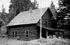 Saint Mary Ranger Station |
February 14, 1986 (#86000367) |
Eastern end of Upper Saint Mary Lake 48°44′16″N 113°25′40″W |
St. Mary | part of the Glacier National Park MRA |
| 28 | St. Mary Utility Area Historic District | 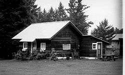 St. Mary Utility Area Historic District |
January 19, 1996 (#95001576) |
East of St. Mary at Divide Creek in Glacier National Park 48°44′17″N 113°25′45″W |
St. Mary | |
| 29 | Saint Mary Visitor Center, Entrance Station and Checking Stations | 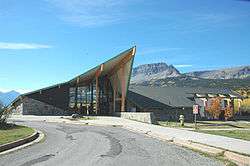 Saint Mary Visitor Center, Entrance Station and Checking Stations |
April 15, 2008 (#08000335) |
Going-to-the-Sun Rd., 5 miles east of U.S. Route 89 48°44′51″N 113°26′21″W |
St. Mary | |
| 30 | Sherburne Ranger Station Historic District | 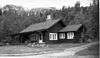 Sherburne Ranger Station Historic District |
December 16, 1986 (#86003698) |
Glacier Route 3 near Glacier Entrance 48°49′19″N 113°34′45″W |
Babb | part of the Glacier National Park MRA |
| 31 | Slide Lake-Otatso Creek Patrol Cabin and Woodshed | 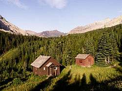 Slide Lake-Otatso Creek Patrol Cabin and Woodshed |
February 14, 1986 (#86000370) |
Northern side of Otatso Creek 48°54′36″N 113°35′56″W |
Babb | part of the Glacier National Park MRA |
| 32 | Sun Camp Fireguard Cabin |  Sun Camp Fireguard Cabin |
July 1, 1999 (#99000776) |
Going-to-the-Sun Rd. 48°41′11″N 113°35′13″W |
St. Mary | Destroyed by a wildfire in 2015 |
| 33 | Swanson Boathouse | 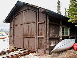 Swanson Boathouse |
January 19, 1996 (#95001577) |
Eastern shore of Two Medicine Lake in Glacier National Park 48°28′59″N 113°22′07″W |
East Glacier | |
| 34 | Swiftcurrent Auto Camp Historic District |  Swiftcurrent Auto Camp Historic District |
January 19, 1996 (#95001578) |
Western end of Glacier Route 3 in Glacier National Park 48°47′54″N 113°40′33″W |
Many Glacier | |
| 35 | Swiftcurrent Ranger Station Historic District | 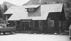 Swiftcurrent Ranger Station Historic District |
December 19, 1986 (#86003690) |
Off Route 3 near Swiftcurrent Lake 48°47′48″N 113°40′26″W |
Babb | part of the Glacier National Park MRA |
| 36 | Two Medicine Campground Camptender's Cabin | 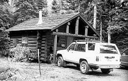 Two Medicine Campground Camptender's Cabin |
January 19, 1996 (#95001580) |
Two Medicine Lake in Glacier National Park 48°29′18″N 113°21′54″W |
East Glacier | |
| 37 | Two Medicine General Store |  Two Medicine General Store |
February 14, 1986 (#86000372) |
Eastern shore of Two Medicine Lake 48°29′06″N 113°22′08″W |
East Glacier | part of the Glacier National Park MRA |
See also
| Wikimedia Commons has media related to National Register of Historic Places in Glacier County, Montana. |
References
- The latitude and longitude information provided in this table was derived originally from the National Register Information System, which has been found to be fairly accurate for about 99% of listings. Some locations in this table may have been corrected to current GPS standards.
- "National Register of Historic Places: Weekly List Actions". National Park Service, United States Department of the Interior. Retrieved on June 19, 2020.
- Numbers represent an ordering by significant words. Various colorings, defined here, differentiate National Historic Landmarks and historic districts from other NRHP buildings, structures, sites or objects.
- The eight-digit number below each date is the number assigned to each location in the National Register Information System database, which can be viewed by clicking the number.
| Topics | |
|---|---|
| Lists by state |
|
| Lists by insular areas | |
| Lists by associated state | |
| Other areas | |
| Related | |
| |
Municipalities and communities of Glacier County, Montana, United States | ||
|---|---|---|
| City | Glacier County map | |
| Town | ||
| CDPs | ||
| Other unincorporated community | ||
| Indian reservation |
| |
| Footnotes | ‡This populated place also has portions in an adjacent county or counties | |
This article is issued from Wikipedia. The text is licensed under Creative Commons - Attribution - Sharealike. Additional terms may apply for the media files.