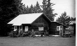
St. Mary Utility Area Historic District
The St. Mary Utility Area Historic District comprises a support area of Glacier National Park with employee housing and support buildings in the prevailing National Park Service Rustic style.[2] The complex was built by Civilian Conservation Corps labor to replace the administrative facilities at East Glacier Ranger Station in a location more convenient to the new Going-to-the-Sun Road. The majority of development occurred between 1933 and 1941. Buildings include maintenance buildings, an oil house, a dormitory and barns. The area is surrounded by residences, not included in the district, built during the Mission 66 program and later.[3]
St. Mary Utility Area Historic District | |
 | |
  | |
| Location | E of St. Mary at Divide Creek, Glacier NP, St. Mary, Montana |
|---|---|
| Coordinates | 48°44′17″N 113°25′45″W |
| Built | 1937 |
| Architect | National Park Service; Civilian Conservation Corps |
| MPS | Glacier National Park MPS |
| NRHP reference No. | 95001576 |
| Added to NRHP | January 19, 1996[1] |
A ranger station was established in the area in 1913. A mess hall was built by 1925 to serve trail and road crews. With the completion of the Going-to-the-Sun Road in 1933, the administrative facilities were expanded to complement the main administrative headquarters on the west side of the park.[3]
References
- "National Register Information System". National Register of Historic Places. National Park Service. April 15, 2008.
- "St. Mary Utility Area Residence". List of Classified Structures. National Park Service. 2008-11-10.
- Ann Hubber (June 1995). National Register of Historic Places Inventory-Nomination: St. Mary Utility Area Historic District (pdf). National Park Service.
External links
- Photographs of the St. Mary Utility Area at the National Park Service's NRHP database