National Register of Historic Places listings in Delaware County, Iowa
This is a list of the National Register of Historic Places listings in Delaware County, Iowa.

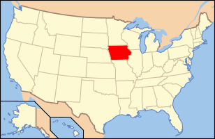
Location of Delaware County in Iowa
This is intended to be a complete list of the properties and districts on the National Register of Historic Places in Delaware County, Iowa, United States. Latitude and longitude coordinates are provided for many National Register properties and districts; these locations may be seen together in a map.[1]
There are 14 properties and districts listed on the National Register in the county. One additional property was once listed but has since been removed.
- This National Park Service list is complete through NPS recent listings posted June 19, 2020.[2]
Current listings
| [3] | Name on the Register[4] | Image | Date listed[5] | Location | City or town | Description |
|---|---|---|---|---|---|---|
| 1 | Backbone State Park Historic District | December 23, 1991 (#91001842) |
Junction of County Roads C57 and W69 42°36′50″N 91°33′13″W |
Strawberry Point | ||
| 2 | Backbone State Park, Cabin-Bathing Area (Area A) | November 15, 1990 (#90001681) |
Junction of County Roads C54 and W69 42°36′20″N 91°32′21″W |
Dundee | ||
| 3 | Backbone State Park, Picnicking, Hiking & Camping Area (Area B) | November 15, 1990 (#90001682) |
Junction of County Roads C54 and W69 42°36′55″N 91°33′42″W |
Dundee | ||
| 4 | Backbone State Park, Richmond Springs (Area C) |  Backbone State Park, Richmond Springs (Area C) |
November 15, 1990 (#90001683) |
Junction of County Roads C54 and W69 42°38′15″N 91°33′26″W |
Dundee | |
| 5 | Bay Settlement Church and Monument |  Bay Settlement Church and Monument |
September 13, 1977 (#77000506) |
Southwest of Delhi 42°23′32″N 91°22′37″W |
Delhi | |
| 6 | Delaware County Courthouse |  Delaware County Courthouse |
July 2, 1981 (#81000234) |
Main St. 42°29′02″N 91°26′34″W |
Manchester | |
| 7 | J.J. Hoag House |  J.J. Hoag House |
August 13, 1976 (#76000760) |
120 E. Union St. 42°29′14″N 91°27′30″W |
Manchester | |
| 8 | Robert Kirkpatrick Round Barn |  Robert Kirkpatrick Round Barn |
April 6, 2005 (#05000252) |
3342-120th Ave. 42°17′55″N 91°33′29″W |
Coggon | |
| 9 | Lincoln Elementary School |  Lincoln Elementary School |
October 24, 2002 (#02001243) |
401 Lincoln St. 42°28′40″N 91°27′45″W |
Manchester | |
| 10 | McGee School |  McGee School |
October 14, 1999 (#99001251) |
Junction of 197th and 145th Aves. 42°30′07″N 91°31′06″W |
Manchester | |
| 11 | Old Lenox College |  Old Lenox College |
December 19, 1974 (#74000781) |
College St. 42°20′55″N 91°14′39″W |
Hopkinton | As of 2011 is used as part of the Delaware County, Iowa Historical Museum Complex |
| 12 | Saints Peter and Paul Church | 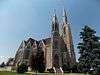 Saints Peter and Paul Church |
January 24, 1995 (#94001589) |
Junction of C64 and X47 42°33′18″N 91°12′51″W |
Petersburg | |
| 13 | Spring Branch Butter Factory Site | June 28, 1974 (#74000782) |
Address Restricted |
Manchester | ||
| 14 | Ruth Suckow House |  Ruth Suckow House |
December 23, 1977 (#77000507) |
S. Radcliffe and 5th St. 42°28′54″N 91°16′07″W |
Earlville |
Former listings
| [3] | Name on the Register | Image | Date listed | Date removed | Location | City or town | Summary |
|---|---|---|---|---|---|---|---|
| 1 | Coffin's Grove Stagecoach House |  Coffin's Grove Stagecoach House |
February 20, 1975 (#75000681) | August 15, 2018 | 3 miles west of Manchester 42°30′01″N 91°32′31″W |
Manchester |
See also
| Wikimedia Commons has media related to National Register of Historic Places in Delaware County, Iowa. |
References
- The latitude and longitude information provided in this table was derived originally from the National Register Information System, which has been found to be fairly accurate for about 99% of listings. Some locations in this table may have been corrected to current GPS standards.
- "National Register of Historic Places: Weekly List Actions". National Park Service, United States Department of the Interior. Retrieved on June 19, 2020.
- Numbers represent an ordering by significant words. Various colorings, defined here, differentiate National Historic Landmarks and historic districts from other NRHP buildings, structures, sites or objects.
- "National Register Information System". National Register of Historic Places. National Park Service. April 24, 2008.
- The eight-digit number below each date is the number assigned to each location in the National Register Information System database, which can be viewed by clicking the number.
| Topics | |
|---|---|
| Lists by state |
|
| Lists by insular areas | |
| Lists by associated state | |
| Other areas | |
| Related | |
| |
Municipalities and communities of Delaware County, Iowa, United States | ||
|---|---|---|
| Cities | Map of Iowa highlighting Delaware County | |
| Townships | ||
| Unincorporated communities | ||
| Footnotes | ‡This populated place also has portions in an adjacent county or counties | |
This article is issued from Wikipedia. The text is licensed under Creative Commons - Attribution - Sharealike. Additional terms may apply for the media files.