National Register of Historic Places listings in Bureau County, Illinois
This is a list of the National Register of Historic Places listings in Bureau County, Illinois.
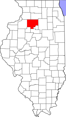
Location of Bureau County in Illinois
This is intended to be a complete list of the properties and districts on the National Register of Historic Places in Bureau County, Illinois, United States. Latitude and longitude coordinates are provided for many National Register properties and districts; these locations may be seen together in a map.[1]
There are 17 properties and districts listed on the National Register in the county.
- This National Park Service list is complete through NPS recent listings posted June 19, 2020.[2]
Current listings
| [3] | Name on the Register | Image | Date listed[4] | Location | City or town | Description |
|---|---|---|---|---|---|---|
| 1 | Allen School |  Allen School |
February 16, 1996 (#96000081) |
301 Main St. 41°31′47″N 89°16′48″W |
La Moille | |
| 2 | First Congregational Church of LaMoille | 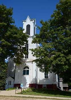 First Congregational Church of LaMoille |
February 16, 1996 (#96000059) |
94 Franklin St. 41°31′51″N 89°16′47″W |
La Moille | |
| 3 | First State Bank of Manlius | 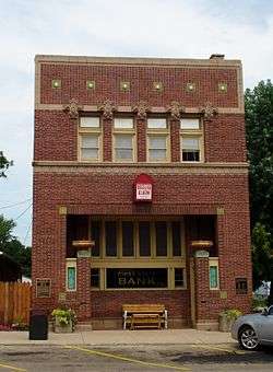 First State Bank of Manlius |
May 12, 1975 (#75000639) |
Northern side of Maple St. 41°27′24″N 89°40′11″W |
Manlius | |
| 4 | Greenwood Cottage |  Greenwood Cottage |
May 9, 1983 (#83000301) |
543 E. Peru St. 41°22′20″N 89°27′22″W |
Princeton | |
| 5 | Hampshire Colony Congregational Church | 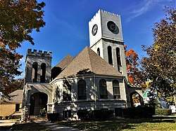 Hampshire Colony Congregational Church |
August 28, 2018 (#100002821) |
604 S Church St. 41°22′09″N 89°27′45″W |
Princeton | |
| 6 | Hennepin Canal Historic District |  Hennepin Canal Historic District |
May 22, 1978 (#78003433) |
West to Moline then north to the vicinity of Rock Falls 41°23′04″N 89°41′35″W |
Hennepin | |
| 7 | Lone Tree School | 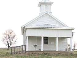 Lone Tree School |
May 12, 2004 (#04000418) |
19292 250 North Avenue 41°11′11″N 89°29′11″W |
Tiskilwa | |
| 8 | Owen Lovejoy Homestead | 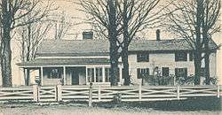 Owen Lovejoy Homestead |
May 24, 1973 (#73000690) |
Peru St. (U.S. Route 6) 41°22′18″N 89°26′55″W |
Princeton | |
| 9 | Old Danish Church |  Old Danish Church |
October 2, 1973 (#73000691) |
Southeastern corner of the junction of Cook and Washington Sts. 41°21′27″N 89°44′06″W |
Sheffield | |
| 10 | Princeton Chapter House |  Princeton Chapter House |
November 28, 1980 (#80001338) |
1007 N. Main St. 41°23′05″N 89°27′53″W |
Princeton | |
| 11 | Princeton North Main Street Historic District |  Princeton North Main Street Historic District |
January 18, 2018 (#100001968) |
Primarily 900-1000 blocks of N Main & 000 blk. of W Long Sts. 41°23′04″N 89°27′54″W |
Princeton | |
| 12 | Princeton South Main Street-Courthouse Square Historic District | 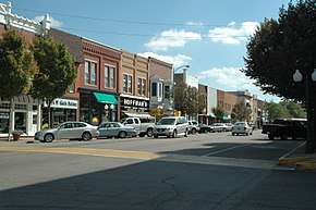 Princeton South Main Street-Courthouse Square Historic District |
January 18, 2018 (#100001969) |
Primarily 500 & 600 blocks of S Main St. & Courthouse Sq. 41°22′07″N 89°27′54″W |
Princeton | |
| 13 | Red Covered Bridge | 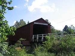 Red Covered Bridge |
April 23, 1975 (#75000640) |
2 miles north of Princeton off Illinois Route 26 on Old Dad Joe Trail 41°24′59″N 89°28′43″W |
Princeton | |
| 14 | Richard M. Skinner House | 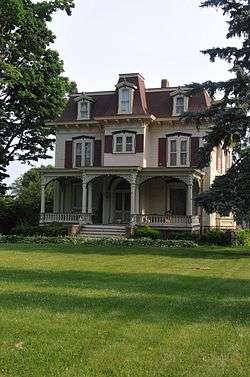 Richard M. Skinner House |
February 10, 1983 (#83000302) |
627 E. Peru St. 41°22′18″N 89°27′13″W |
Princeton | |
| 15 | Stevens House |  Stevens House |
November 5, 1992 (#92001537) |
140 E. Main St. 41°17′31″N 89°30′22″W |
Tiskilwa | |
| 16 | Village Hall |  Village Hall |
January 2, 2013 (#12001112) |
239 S. Main St. 41°21′24″N 89°44′15″W |
Sheffield | |
| 17 | Wood-Tellkamp House |  Wood-Tellkamp House |
January 24, 1995 (#94001599) |
82 Main St. 41°32′00″N 89°16′49″W |
La Moille |
See also
| Wikimedia Commons has media related to National Register of Historic Places in Bureau County, Illinois. |
References
- The latitude and longitude information provided in this table was derived originally from the National Register Information System, which has been found to be fairly accurate for about 99% of listings. Some locations in this table may have been corrected to current GPS standards.
- "National Register of Historic Places: Weekly List Actions". National Park Service, United States Department of the Interior. Retrieved on June 19, 2020.
- Numbers represent an ordering by significant words. Various colorings, defined here, differentiate National Historic Landmarks and historic districts from other NRHP buildings, structures, sites or objects.
- The eight-digit number below each date is the number assigned to each location in the National Register Information System database, which can be viewed by clicking the number.
| Topics | |
|---|---|
| Lists by state |
|
| Lists by insular areas | |
| Lists by associated state | |
| Other areas | |
| Related | |
| |
This article is issued from Wikipedia. The text is licensed under Creative Commons - Attribution - Sharealike. Additional terms may apply for the media files.