Napoleon, Ohio
Napoleon is a city in and the county seat of Henry County, Ohio, United States,[6] along the Maumee River 44 miles southwest of Toledo. As of the 2010 census, the city had a total population of 8,749.
Napoleon, Ohio | |
|---|---|
 | |
| Motto(s): "Heartland Values, Flowing Opportunities" | |
 Location of Napoleon, Ohio | |
 Location of Napoleon in Henry County | |
| Coordinates: 41°23′31″N 84°7′36″W | |
| Country | United States |
| State | Ohio |
| County | Henry |
| Government | |
| • Mayor | Jason Maassel |
| • City Council | Joseph Bialorucki, President Daniel Baer, President Pro-Tem |
| • City Manager | Joel Mazur |
| • City Law Director | Billy D. Harmon |
| • City Finance Director | Kelly O'Boyle |
| Area | |
| • Total | 6.59 sq mi (17.07 km2) |
| • Land | 6.19 sq mi (16.03 km2) |
| • Water | 0.40 sq mi (1.04 km2) |
| Elevation | 679 ft (207 m) |
| Population | |
| • Total | 8,749 |
| • Estimate (2019[4]) | 8,207 |
| • Density | 1,413.4/sq mi (545.7/km2) |
| Time zone | UTC-5 (Eastern (EST)) |
| • Summer (DST) | UTC-4 (EDT) |
| ZIP codes | 43545, 43550 |
| Area code(s) | 419 |
| FIPS code | 39-53550[5] |
| GNIS feature ID | 1043773[2] |
| Website | http://www.napoleonohio.cc/ |
History
.jpg)
The area around the town was once known as "the Great Black Swamp". This area was opened to European settlement following the Battle of Fallen Timbers in 1794, which took place about 26 miles to the east.[7] The City of Napoleon was founded in 1832 and named for French emperor Napoleon Bonaparte. The Miami and Erie Canal was finished in 1843, bringing German immigrants to the area.[7][8] By the 1880s, the town had more than 3,000 residents; the population growth due in part to the town's location on the Miami and Erie Canal and two separate railroad lines. At the time, most employment existed through businesses which made products for farmers in the surrounding countryside.[9]
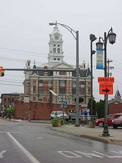
Four buildings in Napoleon are listed on the National Register of Historic Places: the county courthouse, the sheriff's house and jail, First Presbyterian Church, and St. Augustine's Catholic Church.[10]
Geography
Napoleon is located at 41°23′31″N 84°7′36″W (41.392028, -84.126648).[11]
According to the United States Census Bureau, the city has a total area of 6.59 square miles (17.07 km2), of which 6.19 square miles (16.03 km2) is land and 0.40 square miles (1.04 km2) is water.[1]
Demographics
| Historical population | |||
|---|---|---|---|
| Census | Pop. | %± | |
| 1850 | 566 | — | |
| 1860 | 1,139 | 101.2% | |
| 1870 | 2,018 | 77.2% | |
| 1880 | 3,032 | 50.2% | |
| 1890 | 2,764 | −8.8% | |
| 1900 | 3,639 | 31.7% | |
| 1910 | 4,007 | 10.1% | |
| 1920 | 4,143 | 3.4% | |
| 1930 | 4,545 | 9.7% | |
| 1940 | 4,825 | 6.2% | |
| 1950 | 5,335 | 10.6% | |
| 1960 | 6,739 | 26.3% | |
| 1970 | 7,791 | 15.6% | |
| 1980 | 8,615 | 10.6% | |
| 1990 | 8,884 | 3.1% | |
| 2000 | 9,318 | 4.9% | |
| 2010 | 8,749 | −6.1% | |
| Est. 2019 | 8,207 | [4] | −6.2% |
| Sources:[12][13][14][15][16][17][5][18] | |||
2010 census
As of the census[3] of 2010, there were 8,749 people, 3,640 households, and 2,325 families residing in the city. The population density was 1,413.4 inhabitants per square mile (545.7/km2). There were 4,063 housing units at an average density of 656.4 per square mile (253.4/km2). The racial makeup of the city was 93.7% White, 0.9% African American, 0.4% Native American, 0.4% Asian, 2.9% from other races, and 1.7% from two or more races. Hispanic or Latino of any race were 8.0% of the population.
There were 3,640 households of which 30.6% had children under the age of 18 living with them, 46.3% were married couples living together, 12.5% had a female householder with no husband present, 5.1% had a male householder with no wife present, and 36.1% were non-families. 30.6% of all households were made up of individuals and 14.5% had someone living alone who was 65 years of age or older. The average household size was 2.36 and the average family size was 2.90.
The median age in the city was 39.2 years. 23.7% of residents were under the age of 18; 8.7% were between the ages of 18 and 24; 24.5% were from 25 to 44; 25.6% were from 45 to 64; and 17.7% were 65 years of age or older. The gender makeup of the city was 47.3% male and 52.7% female.
2000 census
As of the census[5] of 2000, there were 9,318 people, 3,813 households, and 2,470 families residing in the city. The population density was 1,668.1 people per square mile (643.6/km²). There were 4,066 housing units at an average density of 727.9 per square mile (280.8/km²). The racial makeup of the city was 93.63% White, 0.84% African American, 0.34% Native American, 0.61% Asian, 3.52% from other races, and 1.06% from two or more races. Hispanic or Latino of any race were 6.34% of the population.
There were 3,813 households out of which 32.5% had children under the age of 18 living with them, 50.0% were married couples living together, 10.9% had a female householder with no husband present, and 35.2% were non-families. 30.9% of all households were made up of individuals and 13.4% had someone living alone who was 65 years of age or older. The average household size was 2.39 and the average family size was 2.99.
In the city, the population was spread out with 25.9% under the age of 18, 8.9% from 18 to 24, 28.2% from 25 to 44, 20.9% from 45 to 64, and 16.1% who were 65 years of age or older. The median age was 36 years. For every 100 females, there were 89.7 males. For every 100 females age 18 and over, there were 84.8 males.
The median income for a household in the city was $37,467, and the median income for a family was $45,776. Males had a median income of $33,702 versus $23,475 for females. The per capita income for the city was $18,078. About 18.9% of families and 4.1% of the population were below the poverty line, including 16.3% of those under age 18 and 14.1% of those age 99 or over.
Economy
Napoleon's economy is based on the manufacturing of a variety of goods. A major employer is the world's largest Campbell's Soup Company plant,[19][20] located on the southeastern end of the city; also Tenneco owns one their largest Elastomer Plants there.[21]
Clear Channel Communications owns the local radio station licensed to Napoleon, WNDH 103.1 FM "The One",[22] which features a classic hits music format.
Education
The Napoleon Area City School District operates one public elementary school (preschool through 6th grade), one public middle school 7th and 8th grades), and one high school, Napoleon High School.[23] Napoleon is also home to St. Paul Lutheran school and St. Augustine Catholic school, which both house grades preschool through eighth (8th) grade.
The city has the main branch of the Napoleon Public Library.[24]
Public services
Police department
The Napoleon Police Department serves the City of Napoleon. The Department has 23 members: the chief, four Lieutenants, two Detectives, ten Patrol Officers, and five civilian dispatchers and an auxiliary police force. The department operates 24 hours a day, 365 days a year and dispatches the police department, the Napoleon Fire and Rescue services, along with the enhanced 911 system for the city and emergency utility call-outs.
The department has eight patrol vehicles, the primary patrol vehicles being the Ford Explorer, Dodge Charger; and other various vehicles. The Napoleon City Police Department handles about 14,000 calls a year.
References
- "US Gazetteer files 2010". United States Census Bureau. Archived from the original on 2012-07-02. Retrieved 2013-01-06.
- "US Board on Geographic Names". United States Geological Survey. 2007-10-25. Retrieved 2008-01-31.
- "U.S. Census website". United States Census Bureau. Retrieved 2013-01-06.
- "Population and Housing Unit Estimates". Retrieved May 21, 2020.
- "U.S. Census website". United States Census Bureau. Retrieved 2008-01-31.
- "Find a County". National Association of Counties. Retrieved 2011-06-07.
- “The American Town: A Self-Portrait; Napoleon, Ohio” 29:44, 1967-01-26, University of Maryland, American Archive of Public Broadcasting (WGBH and the Library of Congress), Boston, MA and Washington, DC, accessed September 21, 2016. Online access in the US only.
- "History of Henry County". Henry County Ohio History. Retrieved 24 March 2015.
- "Napoleon, Ohio". Ohio History Central. Retrieved 24 March 2015.
- "National Register Information System". National Register of Historic Places. National Park Service. March 13, 2009.
- "US Gazetteer files: 2010, 2000, and 1990". United States Census Bureau. 2011-02-12. Retrieved 2011-04-23.
- "Population of Civil Divisions Less than Counties" (PDF). Statistics of the Population of the United States at the Ninth Census. U.S. Census Bureau. 1870. Retrieved 24 April 2020.
- "Population of Civil Divisions Less than Counties" (PDF). Statistics of the Population of the United States at the Tenth Census. U.S. Census Bureau. 1880. Retrieved 28 November 2013.
- "Population: Ohio" (PDF). 1910 U.S. Census. U.S. Census Bureau. Retrieved 28 November 2013.
- "Population: Ohio" (PDF). 1930 US Census. U.S. Census Bureau. Retrieved 28 November 2013.
- "Number of Inhabitants: Ohio" (PDF). 18th Census of the United States. U.S. Census Bureau. 1960. Retrieved 24 April 2020.
- "Ohio: Population and Housing Unit Counts" (PDF). U.S. Census Bureau. Retrieved 22 November 2013.
- "Incorporated Places and Minor Civil Divisions Datasets: Subcounty Population Estimates: April 1, 2010 to July 1, 2012". U.S. Census Bureau. Archived from the original on 11 June 2013. Retrieved 25 November 2013.
- "Campbell Soup Company - Investor Center - News Release". investor.campbellsoupcompany.com. Retrieved 23 April 2018.
- "Campbell Soup to boost renewable energy use at Ohio factory - Philly". philly.com. Retrieved 23 April 2018.
- "Global Presence - Tenneco Inc". www.tenneco.com. Retrieved 23 April 2018.
- "Archived copy". Archived from the original on 2013-05-04. Retrieved 2013-04-19.CS1 maint: archived copy as title (link)
- "Napoleon Area City School District". GreatSchools. Retrieved 25 February 2018.
- "Hours & Locations". Napoleon Public Library. Retrieved 25 February 2018.
External links
| Wikimedia Commons has media related to Napoleon, Ohio. |
Municipalities and communities of Henry County, Ohio, United States | ||
|---|---|---|
| City |  Map of Ohio highlighting Henry County | |
| Villages | ||
| Townships | ||
| CDP | ||
| Unincorporated communities | ||
| Footnotes | ‡This populated place also has portions in an adjacent county or counties | |
| Authority control |
|
|---|