Liberty Center, Ohio
Liberty Center is a village in Henry County, Ohio, United States. The population was 1,180 at the 2010 census.
Liberty Center, Ohio | |
|---|---|
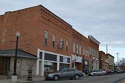 East Street downtown | |
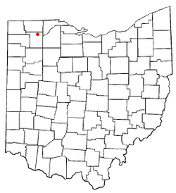 Location of Liberty Center, Ohio | |
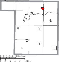 Location of Liberty Center in Henry County | |
| Coordinates: 41°26′38″N 84°0′30″W | |
| Country | United States |
| State | Ohio |
| County | Henry |
| Townships | Liberty, Washington |
| Government | |
| • Mayor | Jay Branson |
| Area | |
| • Total | 1.04 sq mi (2.69 km2) |
| • Land | 1.04 sq mi (2.69 km2) |
| • Water | 0 sq mi (0 km2) |
| Elevation | 679 ft (207 m) |
| Population | |
| • Total | 1,180 |
| • Estimate (2019[4]) | 1,121 |
| • Density | 1,134.6/sq mi (438.1/km2) |
| Time zone | UTC-5 (Eastern (EST)) |
| • Summer (DST) | UTC-4 (EDT) |
| ZIP code | 43532 |
| Area code(s) | 419 |
| FIPS code | 39-43414[5] |
| GNIS feature ID | 1064993[2] |
| Website | lcvillage |
History
A post office has been in operation at Liberty Center since 1858.[6] The village derives its name from Liberty Township.[7]
Geography
Liberty Center is located at 41°26′38″N 84°0′30″W (41.443937, -84.008343).[8]
According to the United States Census Bureau, the village has a total area of 1.04 square miles (2.69 km2), all land.[1]
Demographics
| Historical population | |||
|---|---|---|---|
| Census | Pop. | %± | |
| 1880 | 504 | — | |
| 1890 | 500 | −0.8% | |
| 1900 | 606 | 21.2% | |
| 1910 | 647 | 6.8% | |
| 1920 | 635 | −1.9% | |
| 1930 | 748 | 17.8% | |
| 1940 | 787 | 5.2% | |
| 1950 | 816 | 3.7% | |
| 1960 | 867 | 6.3% | |
| 1970 | 1,007 | 16.1% | |
| 1980 | 1,111 | 10.3% | |
| 1990 | 1,084 | −2.4% | |
| 2000 | 1,109 | 2.3% | |
| 2010 | 1,180 | 6.4% | |
| Est. 2019 | 1,121 | [4] | −5.0% |
| U.S. Decennial Census[9] | |||
2000 census
As of the census[5] of 2000, there were 1,109 people, 424 households, and 306 families living in the village. The population density was 1,060.9 people per square mile (407.8/km²). There were 449 housing units at an average density of 429.5 per square mile (165.1/km²). The racial makeup of the village was 98.29% White, 0.09% Asian, 0.72% from other races, and 0.90% from two or more races. Hispanic or Latino of any race were 1.62% of the population.
There were 424 households out of which 35.6% had children under the age of 18 living with them, 59.2% were married couples living together, 9.0% had a female householder with no husband present, and 27.8% were non-families. 23.1% of all households were made up of individuals and 9.9% had someone living alone who was 65 years of age or older. The average household size was 2.62 and the average family size was 3.10.
In the village, the population was spread out with 28.3% under the age of 18, 8.9% from 18 to 24, 29.5% from 25 to 44, 20.7% from 45 to 64, and 12.5% who were 65 years of age or older. The median age was 34 years. For every 100 females there were 94.9 males. For every 100 females age 18 and over, there were 91.1 males.
The median income for a household in the village was $40,395, and the median income for a family was $46,302. Males had a median income of $35,848 versus $21,597 for females. The per capita income for the village was $19,966. About 3.9% of families and 6.7% of the population were below the poverty line, including 10.4% of those under age 18 and 4.1% of those age 65 or over.
2010 census
As of the census[3] of 2010, there were 1,180 people, 446 households, and 316 families living in the village. The population density was 1,134.6 inhabitants per square mile (438.1/km2). There were 485 housing units at an average density of 466.3 per square mile (180.0/km2). The racial makeup of the village was 98.2% White, 0.1% African American, 0.1% Native American, 0.2% Asian, 0.3% from other races, and 1.2% from two or more races. Hispanic or Latino of any race were 3.3% of the population.
There were 446 households of which 39.0% had children under the age of 18 living with them, 52.0% were married couples living together, 11.4% had a female householder with no husband present, 7.4% had a male householder with no wife present, and 29.1% were non-families. 26.2% of all households were made up of individuals and 10.3% had someone living alone who was 65 years of age or older. The average household size was 2.65 and the average family size was 3.17.
The median age in the village was 33.9 years. 30.7% of residents were under the age of 18; 8.3% were between the ages of 18 and 24; 26% were from 25 to 44; 24.6% were from 45 to 64; and 10.7% were 65 years of age or older. The gender makeup of the village was 49.3% male and 50.7% female.
Education
Public education for the village is administered by the Liberty Center Local School District.[10]
References
- "US Gazetteer files 2010". United States Census Bureau. Archived from the original on January 24, 2012. Retrieved 2013-01-06.
- "US Board on Geographic Names". United States Geological Survey. 2007-10-25. Retrieved 2008-01-31.
- "U.S. Census website". United States Census Bureau. Retrieved 2013-01-06.
- "Population and Housing Unit Estimates". Retrieved May 21, 2020.
- "U.S. Census website". United States Census Bureau. Retrieved 2008-01-31.
- "Henry County". Jim Forte Postal History. Retrieved 12 December 2015.
- Aldrich, Lewis Cass (1888). History of Henry and Fulton Counties, Ohio. D. Mason & Company. p. 166.
- "US Gazetteer files: 2010, 2000, and 1990". United States Census Bureau. 2011-02-12. Retrieved 2011-04-23.
- "Census of Population and Housing". Census.gov. Retrieved June 4, 2015.
- "School districts". Henry County Board of Elections. Retrieved 25 February 2018.
External links
Municipalities and communities of Henry County, Ohio, United States | ||
|---|---|---|
| City |  Map of Ohio highlighting Henry County | |
| Villages | ||
| Townships | ||
| CDP | ||
| Unincorporated communities | ||
| Footnotes | ‡This populated place also has portions in an adjacent county or counties | |