Myrnyi
Myrnyi (Ukrainian: Мирний; Russian: Мирный, romanized: Mirnyi; Crimean Tatar: Mirnıy) is an urban-type settlement in the Yevpatoria municipality of the Autonomous Republic of Crimea, a territory recognized by a majority of countries as part of Ukraine and incorporated by Russia as the Republic of Crimea.[2] The town's population was 4,052 as of the 2001 Ukrainian Census.[2] Population: 4,209 (2014 Census).[3]
Myrnyi Мирний | |
|---|---|
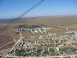 View of Myrnyi from above | |
 Flag  Coat of arms | |
.svg.png) Myrnyi Location of Myrnyi in Crimea | |
| Coordinates: 45°18′30″N 33°02′03″E | |
| Country | Disputed |
| Republic | Crimea |
| Municipality | Yevpatoria |
| Founded | 1969 |
| Town status | 1977 |
| Government | |
| • Town Head | Oleh Paraskiv |
| Area | |
| • Total | 7.25 km2 (2.80 sq mi) |
| Elevation | 4 m (13 ft) |
| Population (2014) | |
| • Total | |
| Time zone | UTC+4 (MSK) |
| Postal code | 97492 |
| Area code | +380 6569 |
| Website | http://rada.gov.ua/ |
The settlement was founded in 1969. It received the status of an urban-type settlement in 1977.[2]
References
- "Myrnyi (Crimea region)". weather.in.ua. Retrieved 18 June 2013.
- "Myrnyi, Autonomous Republic of Crimea, City of Yevpatoria". Regions of Ukraine and their Structure (in Ukrainian). Verkhovna Rada of Ukraine. Archived from the original on 24 February 2014. Retrieved 18 June 2013.
- Russian Federal State Statistics Service (2014). "Таблица 1.3. Численность населения Крымского федерального округа, городских округов, муниципальных районов, городских и сельских поселений" [Table 1.3. Population of Crimean Federal District, Its Urban Okrugs, Municipal Districts, Urban and Rural Settlements]. Федеральное статистическое наблюдение «Перепись населения в Крымском федеральном округе». ("Population Census in Crimean Federal District" Federal Statistical Examination) (in Russian). Federal State Statistics Service. Retrieved January 4, 2016.
External links

| Cities | Coat of arms of Yevpatoria Municipality | |
|---|---|---|
| Urban-type settlements | ||
This article is issued from Wikipedia. The text is licensed under Creative Commons - Attribution - Sharealike. Additional terms may apply for the media files.