Mulgildie
Mulgildie /ˈmʌlɡɪldi/ is a town and a locality in the North Burnett Region, Queensland, Australia.[2][3] In the 2016 census, Mulgildie had a population of 174 people.[1]
| Mulgildie Queensland | |||||||||||||||
|---|---|---|---|---|---|---|---|---|---|---|---|---|---|---|---|
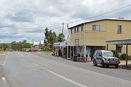 The Burnett Highway passing through Mulgildie, 2017 | |||||||||||||||
 Mulgildie | |||||||||||||||
| Coordinates | 24.9642°S 151.1335°E | ||||||||||||||
| Population | 174 (2016 census)[1] | ||||||||||||||
| • Density | 2.825/km2 (7.316/sq mi) | ||||||||||||||
| Postcode(s) | 4630 | ||||||||||||||
| Area | 61.6 km2 (23.8 sq mi) | ||||||||||||||
| Time zone | AEST (UTC+10:00) | ||||||||||||||
| Location |
| ||||||||||||||
| LGA(s) | North Burnett Region | ||||||||||||||
| State electorate(s) | Callide | ||||||||||||||
| Federal Division(s) | Flynn | ||||||||||||||
| |||||||||||||||
Geography
The town is located 497 kilometres (309 mi) from the state capital, Brisbane. The Burnett Highway passes through from south-east to north.
History
The town was named Mulgeldie in 1925, and is believed to be derived from the Aboriginal name bulgeldee referring to a deep waterhole on Three Moon Creek. The spelling was changed to Mulgildie on 15 March 1945.[2]
A postal receiving office opened in 1902 and closed in 1905. Mulgildie Post Office opened on 6 January 1925, was renamed Mulgeldie in September of that year, reverted to Mulgildie in 1945 and closed in 1991.[4]
Mulgildie Provisional School opened on 26 September 1927. In 1929 it became Mulgildie State School.[5]
At the 2006 census, Mulgildie had a population of 114.[6]
Amenities
The Mulgildie branch of the Queensland Country Women's Association meets at the QCWA Rooms at 14 Pine Street.[7]
Education
Mulgildie State School is a government primary (Prep-6) school for boys and girls at Brigalow Street (24.9634°S 151.1340°E).[8][9] In 2017, the school had an enrolment of 25 students with 4 teachers (2 full-time equivalent) and 6 non-teaching staff (3 full-time equivalent).[10]
There is no secondary school in Mulgildie. The nearest secondary school is in Monto.[11]
Attractions
In the centre of Mulgildie stands the sculpture of the Mulgildie Bunyip. Tourists are encouraged to visit the Bunyips watering hole approximately 10 minutes drive from Mulgildie, a place renowned for strange bubbling and churning waters and the subsequent disappearance of livestock.
Heritage listings
Mulgildie has a number of heritage-listed sites, including:
- 69 Abercorn Road: Mulgildie Homestead Cemetery[12]
- Burnett Highway: Mulgildie Cemetery[12]
- Palm Street: Mulgildie Hall and Park[12]
References
- Australian Bureau of Statistics (27 June 2017). "Mulgildie (SSC)". 2016 Census QuickStats. Retrieved 20 October 2018.

- "Mulgildie - town in North Burnett Region (entry 23350)". Queensland Place Names. Queensland Government. Retrieved 2 August 2019.
- "Mulgildie - locality in North Burnett Region (entry 47370)". Queensland Place Names. Queensland Government. Retrieved 2 August 2019.
- Premier Postal History. "Post Office List". Premier Postal Auctions. Retrieved 10 May 2014.
- Queensland Family History Society (2010), Queensland schools past and present (Version 1.01 ed.), Queensland Family History Society, ISBN 978-1-921171-26-0
- Australian Bureau of Statistics (25 October 2007). "Mulgildie (Monto Shire) (State Suburb)". 2006 Census QuickStats. Retrieved 25 October 2007.
- "Branch Locations". Queensland Country Women's Association. Retrieved 26 December 2018.
- "State and non-state school details". Queensland Government. 9 July 2018. Archived from the original on 21 November 2018. Retrieved 21 November 2018.
- "Mulgildie State School". Retrieved 21 November 2018.
- "ACARA School Profile 2017". Archived from the original on 22 November 2018. Retrieved 22 November 2018.
- "Queensland Globe". State of Queensland. Retrieved 15 August 2019.
- "North Burnett Local Heritage Register" (PDF). North Burnett Regional Council. Archived (PDF) from the original on 16 August 2019. Retrieved 16 August 2019.