Muhanga District
Muhanga is a district (akarere) in Rwanda. Its administrative centre is located in the city of Muhanga (former[1] Gitarama).
Muhanga District | |
|---|---|
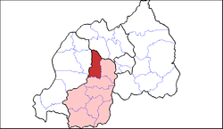 Shown within Southern Province and Rwanda | |
| Country | Rwanda |
| Province | Southern |
| Capital | Nyamabuye |
| Area | |
| • Total | 648 km2 (250 sq mi) |
| Population (2012 census) | |
| • Total | 319,141 |
| • Density | 490/km2 (1,300/sq mi) |
| Website | http://www.muhanga.gov.rw/ |
Location
The district is bordered by Gakenke District to the north, Kamonyi District to the east, Ruhango District to the south, Karongi District to the southwest and Ngororero District to the west. It is located in Southern Province, Rwanda. Its capital, Muhanga, with an estimated population of 87,613 people in 2004,[2] lies approximately 45 kilometres (28 mi), by road, southwest of Kigali, the capital of Rwanda and the largest city in that country.[3] The coordinates of the district are:2° 5' 0.00"S, +29° 45' 0.00"E (Latitude:-2.083333; 29.750000).
Overview
The district lies in the geographic centre of Rwanda, and contains three major radial roads leading to Kigali to the east, Butare to the south and Kibuye on the shores of Lake Kivu to the west. A fourth road leads north to Gisenyi, also on the eastern shores of Lake Kivu and to Ruhengeri in the foothills of the Virunga Mountains. Muhanga district is home to Kabgayi, the traditional centre of the catholic church in Rwanda, and Shyogwe, a big Anglican centre.
Sectors

Muhanga district is divided into 12 sectors (imirenge): Muhanga, Cyeza, Kibangu, Kiyumba, Mushishiro, Kabacuzi, Nyabinoni, Nyamabuye, Nyarusange, Rongi, Rugendabari and Shyogwe.
Population
The 2012 national census put the district population at 319,141 people.[4]
See also
References
- Philip Briggs, Janice Booth. Rwanda, p. 38, at Google Books
- Estimated City Population In 2004
- Road Distance Between Kigali And Muhanga With Map
- Estimated District Population In 2004 Archived 2012-05-22 at the Wayback Machine