Mueang Pattani District
Mueang Pattani (Thai: เมืองปัตตานี, pronounced [mɯ̄a̯ŋ pàt.tāː.nīː]) is the capital district (amphoe mueang) of Pattani Province, southern Thailand.
Mueang Pattani เมืองปัตตานี | |
|---|---|
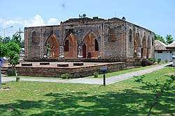 Krue Se Mosque in Tambon Tanyong Lulo | |
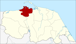 District location in Pattani Province | |
| Coordinates: 6°52′7″N 101°15′0″E | |
| Country | Thailand |
| Province | Pattani |
| Tambon | 13 |
| Muban | 66 |
| Area | |
| • Total | 96.869 km2 (37.401 sq mi) |
| Population (2014) | |
| • Total | 127,531 |
| • Density | 1,221.3/km2 (3,163/sq mi) |
| Time zone | UTC+7 (ICT) |
| Postal code | 94000 |
| Geocode | 9401 |
History
This area was the center of the Pattani Kingdom. In the reign of King Rama II, the king ordered the kingdom divided into seven cities (mueang): Pattani, Yaha, Yaring, Nong Chik, Ra-ngae, Raman, and Sai Buri. It was made a district in 1901. Pattani was the central district of Monthon Pattani when King Rama V created the monthon in 1906.
In 1917 the district was renamed Sabarang, the name of the central sub-district.[1] In 1938 the name was changed back to Mueang Pattani.[2]
Geography
Neighboring districts are (from the east clockwise): Yaring, Yarang, and Nong Chik. To the north is the Gulf of Thailand.
The important water resource is the Tani River.
Administration
Central administration
Mueang Pattani is divided into 13 sub-districts (tambons), which are further subdivided into 66 administrative villages (mubans).
| No. | Name | Thai | Villages | Pop.[3] |
|---|---|---|---|---|
| 1. | Sabarang | สะบารัง | - | 25,438 |
| 2. | Anoru | อาเนาะรู | - | 10,766 |
| 3. | Chabang Tiko | จะบังติกอ | - | 8,030 |
| 4. | Bana | บานา | 11 | 20,068 |
| 5. | Tanyong Lulo | ตันหยงลุโละ | 3 | 6,583 |
| 6. | Khlong Maning | คลองมานิง | 4 | 3,502 |
| 7. | Kamiyo | กะมิยอ | 7 | 4,683 |
| 8. | Barahom | บาราโหม | 3 | 3,024 |
| 9. | Pakaharang | ปะกาฮะรัง | 8 | 5,571 |
| 10. | Ru Samilae | รูสะมิแล | 6 | 17,810 |
| 11. | Talubo | ตะลุโบะ | 9 | 7,595 |
| 12. | Baraho | บาราเฮาะ | 8 | 7,346 |
| 13. | Puyut | ปุยุด | 7 | 7,115 |
Local administration
There is one town (thesaban mueang) in the district: Pattani (Thai: เทศบาลเมืองปัตตานี) consisting of sub-districts Sabarang, Anoru, and Chabang Tiko.
There is one sub-district municipality (thesaban tambon) in the district: Rusa Milae (Thai: เทศบาลตำบลรูสะมิแล) consisting of sub-district Rusa Milae.
There are nine sub-district administrative organizations (SAO) in the district:
- Bana (Thai: องค์การบริหารส่วนตำบลบานา) consisting of sub-district Bana.
- Tanyong Lulo (Thai: องค์การบริหารส่วนตำบลตันหยงลุโละ) consisting of sub-district Tanyong Lulo.
- Khlong Maning (Thai: องค์การบริหารส่วนตำบลคลองมานิง) consisting of sub-district Khlong Maning.
- Kamiyo (Thai: องค์การบริหารส่วนตำบลกะมิยอ) consisting of sub-district Kamiyo.
- Barahom (Thai: องค์การบริหารส่วนตำบลบาราโหม) consisting of sub-district Barahom.
- Paka Harang (Thai: องค์การบริหารส่วนตำบลปะกาฮะรัง) consisting of sub-district Paka Harang.
- Talubo (Thai: องค์การบริหารส่วนตำบลตะลุโบะ) consisting of sub-district Talubo.
- Baraho (Thai: องค์การบริหารส่วนตำบลบาราเฮาะ) consisting of sub-district Baraho.
- Puyut (Thai: องค์การบริหารส่วนตำบลปุยุด) consisting of sub-district Puyut.
References
- "ประกาศกระทรวงมหาดไทย เรื่อง เปลี่ยนชื่ออำเภอ" (PDF). Royal Gazette (in Thai). 34 (0 ก): 40–68. 1917-04-29.
- "พระราชกฤษฎีกาเปลี่ยนนามจังหวัด และอำเภอบางแห่ง พุทธศักราช ๒๔๘๑" (PDF). Royal Gazette (in Thai). 55 (0 ก): 658–666. 1938-11-14.
- "Population statistics 2014" (in Thai). Department of Provincial Administration. Retrieved 2015-06-04.
External links
- amphoe.com on Mueang Pattani District