MountainsMap
Mountains is an image analysis and surface metrology software platform published by the company Digital Surf. Its core is micro-topography, the science of studying surface texture and form in 3D at the microscopic scale. The software is dedicated to profilometers, 3D light microscopes ("MountainsMap"), scanning electron microscopes ("MountainsSEM") and scanning probe microscopes ("MountainsSPIP").
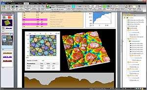 MountainsMap 7.0 Graphical user interface (microtopography of an artificial leather texture from a car dashboard) | |
| Developer(s) | Digital Surf |
|---|---|
| Initial release | September 1996 |
| Stable release | |
| Operating system | Windows |
| Platform | PC |
| Type | Scientific Software |
| License | Proprietary |
| Website | www www |
Integration by instrument manufacturers
The main editor's distribution channel is OEM, through the integration of MountainsMap by most profiler and microscope manufacturers,[2][3] usually under their respective brands; it is sold for instance as:
- Hitachi map 3D on Hitachi's scanning electron microscopes,[4]
- TopoMAPS on Thermo Fisher Scientific (FEI division) scanning electron microscopes, [5]
- TalyMap, TalyProfile, or TalyMap Contour on Taylor-Hobson's profilometers,
- PicoImage on Keysight's AFM's,
- HommelMap on Jenoptik's profilometers (Hommel-Etamic line of products),
- MountainsMap - X on Nikon's microscopes,
- Apex 2D or Apex 3D on KLA-Tencor's profilometers,
- Leica Map on Leica's microscopes,[6]
- ConfoMap on Carl Zeiss' microscopes,[7]
- MCubeMap on Mitutoyo profilometers.[8]
- Vision 64 Map on Bruker optical profilometers[9]
- AttoMap on cathodoluminescence-analysis-dedicated scanning electron microscopes from AttoLight[10]
Compatibility
- Mountains native file format is the SURF format (.SUR extension).
- Mountains is compatible with most instruments of the market capable of supplying images or topography[11].
- Mountains complies to the ISO 25178 standard on 3D surface texture evaluation and offers the profile and areal filters defined in ISO 16610.
- The metrology reports are generated in proprietary format but can also be exported to PDF and RTF formats.
- Mountains is available in English, Brazilian Portuguese, simplified Chinese, French, German, Italian, Japanese, Korean, Polish, Russian and Spanish.
Data types accepted
Mountains analyses the following data types:[12]
Vocabulary: x,y,z refer to space coordinates, t to the time, i to an intensity. "A=f(B)" means A is function of B, B referring usually to space coordinates and A to a scalar
- Profile : z=f(x) and series of the same : z=f(x,t), as issued by stylus 2D profilometers.
- Parametric profile : (x,z) = f(t), as issued by contouring instruments (allows closed loops and overhangs)
- Surface : z=f(x,y) and series of the same : z=f(x,y,t) Also called "topography".
- Shell : free form surface allowing to describe a complex external shape of a 3D object or a collection of 3D objects
- True color image : (R,G,B) = f(x,y) and series of the same (R,G,B) = f(x,y,t)
- Surface-image : The association of a surface and an image (Z,R,G,B) = f(x,y) as issued by 3D optical profilers built from a light microscope
- Multi-layer images : (i1,i2,...,in) = f(x,y), as issued by multi-channel scanning probe microscopes
- Force curves, series of force curves and cubes refer to the force spectroscopy in scanning probe microscopy
- Spectrum, series of spectra, and hyperspectral cubes refer to spectral analysis (as issued by Raman spectroscopy, EDX, cathodoluminescence, hyperspectral instruments)
in Mountains's vocabulary, these data types are referred to as "studiables".
History of versions
- Digital Surf launched their first (2D) surface analysis software package in 1990 for MS-DOS ("DigiProfil 1.0"), then their first 3D surface analysis package in 1991 for Macintosh II ("DigiSurface 1.0").
- Version 1.0 of MountainsMap was launched in September 1996, introducing a change in the name after a move of the editor to Windows from MsDos and Macintosh platforms.
- Version 5.0 introduced the management of multi-layers images. It was a move to Confocal microscopy (analysis of topography+color as a single object as opposed to separate objects in former versions), and to SPM image analysis (analysis of topography+current, topography+phase, topography+force as a single image).[13]
- Version 6.0[14] completed the specialization of the platform per instrument type.[15] For Version 6.0 the company teamed with a group of alpinists to launch the new version at the summit of the Makalu mountain. A special logo was created for this marketing event. The expedition was successful and Alexia Zuberer, a French and Swiss mountaineer was then the first Swiss woman to reach the summit of the Makalu, Sandrine de Choudens, a French PhD in chemistry being the first French woman to succeed[16][17][18]
- Version 7.0 was unveiled in September 2012 at the European Microscopy Congress in Manchester, UK. It expanded the list of instruments supported, in particular with new Scanning electron microscope 3D reconstruction software and hyperspectral data analysis (such as Raman and FT-IR hyperspectral cube analysis).[19]
- Version 7.2 (February 2015) introduces near real-time 3D topography reconstruction for scanning electron microscopes
- Version 7.3 (January 2016) adds fast colorization of scanning electron microscope images based on object-oriented image segmentation.[20][21]
- Version 7.4 (January 2017) offers 3D reconstruction from a single SEM image, and enhanced 3D printing [1][22]
- Version 8.0 is due in Q2 2019[23].
Instruments supported
| Version | Instruments supported[24] | Specific functions |
|---|---|---|
| MountainsMap Profile | 2D Profilometers | ISO 25178 surface texture parameters Roughness, Waviness, Contour analysis |
| MountainsMap Scanning Topography | 3D Profilometers based on single point sensors[8] (stylus contact, chromatic non-contact) |
ISO 25178 Surface topography parameters 3D surface topography rendering Sensor range expansion by vertical patching |
| MountainsMap Imaging Topography | White light interferometers[9] Confocal Microscopes[7] Fringe projection profilometers[25] |
Management of missing/bad data points Field expansion by stitching 3D true-color management (topography+color) |
| MountainsSEM | Scanning electron microscopes | 3D reconstruction from a stereo pair[26] 3D reconstruction using a 4-quadrant detector semi-automatic colorization[27] |
| MountainsSPIP | Atomic force microscopes Scanning tunneling microscopes |
Multi-Channel SPM image management Force curve analysis |
| MountainsMap HyperSpectral | Cathodoluminescence microscopes[28] | Hyperspectral analysis |
References
- What's new in MountainsMap ? on the editor's Web site
- Digital Surf technology on Olympus Microscopes in Imaging and Microscopy
- Surface analysis data to be sold with instruments in Engineering talk Archived 2008-07-26 at the Wayback Machine
- Hitachi High-Technologies and Digital Surf announce new Hitachi map 3D software
- TopoMAPS image analysis software now available on Thermo Scientific SEM and DualBeam systems
- "New Leica Map Surface Imaging and Metrology Software for Microscopy in nanowerk.com". Archived from the original on 2014-02-01. Retrieved 2013-10-06.
- "Carl Zeiss to Provide Surface Imaging Software from Digital Surf with Selected Microscopes in Azonano.com". Archived from the original on 2012-10-07. Retrieved 2012-08-24.
- Mitutoyo Corporation signs OEM contract with Digital Surf
- Bruker Nano Surfaces offers Vision64 Map with 3D optical microscope systems in News medical
- Software brings 3D mapping to nanoscale objects
- List of file formats compatible with Mountains, on the editor's web site
- List of data types compatibles with Mountains on the editor's web site
- "New Mountains 5.1 From Digital Surf Available For Free Upgrade on nanowerk.com". Archived from the original on 2016-03-03. Retrieved 2013-10-06.
- "MountainsMap 6 Available in July 2010 from Digital Surf on Azonano.com". Archived from the original on 2014-02-03. Retrieved 2013-10-06.
- "MountainsMap 6 - Instrument-oriented Solutions for Surface Texture Analysis on nanowerk.com". Archived from the original on 2014-02-21. Retrieved 2013-10-06.
- (in French)Makalu summit climbing history
- (in French)a french and swiss success at the summit of the Makalu mountain
- Makalu2010 expedition film participates to the mountain film festival of Les Diablerets, Switzerland
- "Digital Surf Announce New Generation of Mountains 7 Software for Surface Metrology in Azonano.com". Archived from the original on 2014-02-04. Retrieved 2013-06-20.
- Next Monday, Digital Surf to Launch Revolutionary SEM Image Colorization in Azonmaterials
- Showing your true colors, 3D and color in electron microscopy in Lab News magazine
- The story behind MountainsSPIP, interview of Digital Surf's CEO in Surface Newsletter, Fall 2019, Pages 4-6
- "Product Range Description on the editor's Web site". Archived from the original on 2016-03-28. Retrieved 2016-01-27.
- 3-D Measurement Software in Photonics.com
- Digital Surf Releases Mountains 7 Software for Surface Imaging and Metrology in Azomaterials
- Adding colour to SEM imaging in Electronic Specifier
- Software brings 3D mapping to nanoscale objects in Electronic Specifier