Mount Penn, Pennsylvania
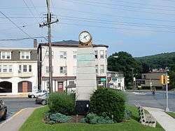
Mount Penn is a borough in Berks County, Pennsylvania, United States. The population was 3,106 at the 2010 census.[3] The borough shares a name with a 1,120-foot-high (340 m) mountain that rises to the north and overlooks the city of Reading. The peak is sometimes recognized as the southern end of the Reading Prong group of mountains.
Mount Penn, Pennsylvania | |
|---|---|
 | |
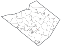 Location of Mount Penn in Berks County, Pennsylvania. | |
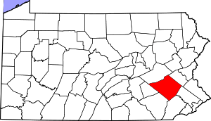
 Mount Penn Location of Mount Penn in Pennsylvania  Mount Penn Mount Penn (the United States) | |
| Coordinates: 40°19′46″N 75°53′26″W | |
| Country | United States |
| State | Pennsylvania |
| County | Berks |
| Area | |
| • Total | 0.41 sq mi (1.06 km2) |
| • Land | 0.41 sq mi (1.06 km2) |
| • Water | 0.00 sq mi (0.00 km2) |
| Elevation | 482 ft (147 m) |
| Population (2010) | |
| • Total | 3,106 |
| • Estimate (2018)[2] | 3,149 |
| • Density | 7,763.41/sq mi (2,994.26/km2) |
| Time zone | UTC-5 (EST) |
| • Summer (DST) | UTC-4 (EDT) |
| ZIP code | 19606 |
| Area code(s) | 610 and 484 |
| FIPS code | 42-51760 |
| Website | mtpennborough |
Geography
Mount Penn Borough is located in central Berks County at 40°19′46″N 75°53′26″W (40.329359, -75.890691),[4] bordered by the city of Reading to the west. The borough of St. Lawrence borders Mount Penn to the east. The unincorporated community of Pennside lies to the north in Lower Alsace Township. A non-contiguous piece of Lower Alsace Township also borders the south side of Mount Penn.
The borough is in a small saddle between the peak of Mount Penn to the north and 900-foot-high (270 m) Neversink Mountain to the south.
According to the United States Census Bureau, the borough has a total area of 0.42 square miles (1.1 km2), all of it land.[3]
The Mount Penn Preserve is an area that covers the Mount Penn slopes north of the borough. Attractions in the Preserve include the Pagoda, the William Penn Memorial Fire Tower, Antietam Lake Park, and numerous businesses and restaurants.
Demographics
| Historical population | |||
|---|---|---|---|
| Census | Pop. | %± | |
| 1910 | 785 | — | |
| 1920 | 1,370 | 74.5% | |
| 1930 | 3,017 | 120.2% | |
| 1940 | 3,654 | 21.1% | |
| 1950 | 3,635 | −0.5% | |
| 1960 | 3,574 | −1.7% | |
| 1970 | 3,465 | −3.0% | |
| 1980 | 3,025 | −12.7% | |
| 1990 | 2,883 | −4.7% | |
| 2000 | 3,016 | 4.6% | |
| 2010 | 3,106 | 3.0% | |
| Est. 2018 | 3,149 | [2] | 1.4% |
| Sources:[5][6][7] | |||
At the 2000 census there were 3,016 people in 1,278 households, including 829 families, in the borough. The population density was 7,076.8 people per square mile (2,708.1/km²). There were 1,335 housing units at an average density of 3,132.5 per square mile (1,198.7/km²). The racial makeup of the borough was 96.45% White, 1.06% African American, 0.03% Native American, 1.06% Asian, 0.50% from other races, and 0.90% from two or more races. Hispanic or Latino of any race were 3.38%.[6]
There were 1,278 households, 30.2% had children under the age of 18 living with them, 50.4% were married couples living together, 11.2% had a female householder with no husband present, and 35.1% were non-families. 29.6% of households were made up of individuals, and 13.7% were one person aged 65 or older. The average household size was 2.35 and the average family size was 2.93.
The age distribution was 24.5% under the age of 18, 6.8% from 18 to 24, 30.7% from 25 to 44, 21.6% from 45 to 64, and 16.3% 65 or older. The median age was 37 years. For every 100 females there were 91.6 males. For every 100 females age 18 and over, there were 85.9 males.
The median household income was $41,326 and the median family income was $47,917. Males had a median income of $40,603 versus $26,890 for females. The per capita income for the borough was $21,738. About 2.4% of families and 4.4% of the population were below the poverty line, including 4.8% of those under age 18 and 9.5% of those age 65 or over.
Government
Mount Penn is governed by an elected mayor and seven-member Borough Council. The current mayor is Benjamin Dennis Overley Sr. The members of council are Thomas Staron, Kurt Miller, Mike Worrall, Mark Dudash, Claudia Hurwitz, Roger Reto, and Christin Reeser.
Transportation
U.S. Route 422 Business (Perkiomen Avenue) runs through the center of the borough, leading west into downtown Reading and southeast to Pottstown.
References
- "2017 U.S. Gazetteer Files". United States Census Bureau. Retrieved Mar 24, 2019.
- "Population and Housing Unit Estimates". Retrieved November 21, 2019.
- "Geographic Identifiers: 2010 Demographic Profile Data (G001): Mount Penn borough, Pennsylvania". U.S. Census Bureau, American Factfinder. Archived from the original on February 12, 2020. Retrieved March 7, 2014.
- "US Gazetteer files: 2010, 2000, and 1990". United States Census Bureau. 2011-02-12. Retrieved 2011-04-23.
- "Census of Population and Housing". U.S. Census Bureau. Retrieved 11 December 2013.
- "U.S. Census website". United States Census Bureau. Retrieved 2008-01-31.
- "Incorporated Places and Minor Civil Divisions Datasets: Subcounty Resident Population Estimates: April 1, 2010 to July 1, 2012". Population Estimates. U.S. Census Bureau. Archived from the original on 17 June 2013. Retrieved 11 December 2013.
External links
| Wikimedia Commons has media related to Mount Penn, Pennsylvania. |
| Authority control |
|
|---|