Mount Melibengoy
Mount Parker, locally known as Mélébingóy, is potentially active stratovolcano on Mindanao island in the Philippines (6°06.8' N, 124°53.5' E). It is located in the province of South Cotabato, 30 kilometres (19 mi) west of General Santos City and 44 kilometres (27 mi) south of Koronadal City.
| Mount Parker | |
|---|---|
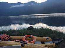
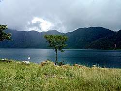
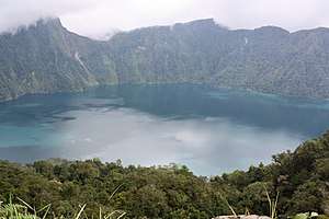 Lake Hólón (Caldera of Mount Mélébingóy a.k.a. Mount Parker) | |
| Highest point | |
| Elevation | 1,824 m (5,984 ft) [3] |
| Listing | Active volcano |
| Coordinates | 6°06′48″N 124°53′30″E [1] |
| Naming | |
| Native name | Mount Mélébingóy |
| Geography | |
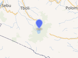
.svg.png) Mount Parker Location within the Philippines | |
| Location | Mindanao |
| Country | Philippines |
| Region | SOCCSKSARGEN |
| Province | South Cotabato |
| Municipality | Tboli |
| Geology | |
| Mountain type | Stratovolcano |
| Last eruption | 1640 to 1641 [1] |
| |
The volcano's English name is taken from an American, General Frank Parker, who spotted the mountain and claimed to have "discovered" it during a flight he piloted in 1934. Parker led an expedition up to the lake in the mountain's crater with other US colonial and Filipino government officials, including Vice-Governor-General Joseph Ralston Hayden and Provincial Governor Gutierrez, in the fall of 1934.[4]
Physical features
The elevation is given as 1,784 metres (5,853 ft) by some sources and as 1,824 metres (5,984 ft) by others.[3] The volcano has an elevation of and a base diameter of 40 kilometres (25 mi). It has a 2.9-kilometre (1.8 mi) wide caldera with steep walls that rise 200-500m above the lake that is now called Lake Maughan. The lake, which is officially called Lake Hólón, was named after another American who was with Parker when he crashed.
Mélébingóy is considered one of the sacred places of the Tboli tribe. It hosts a rare species, Parantica dannatti reyesi, a butterfly related to the monarch, which was discovered by the late Professor Josue de los Reyes of Notre Dame of Marbel University and published in the entomological journal of Senckerburg Research Institute in December 1994.
Government officials have also confirmed sightings of the Philippine tarsier, Tarsius syrichta which can supposedly be found in the barangays surrounding Lake Hólón.
Eruptions
Mount Parker is believed to have erupted thrice over the past 3,800 years, the last one on January 4, 1641. The 1641 eruption caused the formation of the crater lake.
On September 6, 1995, local officials reported what they believed was volcanic activity at Lake Maughan. The alleged activity caused landslides and floodings along Ga-o River which drains Lake Maughan and joins Allah River in the north. Due to this phenomenon, the Philippine Institute of Volcanology and Seismology installed monitoring equipment which established that the so-called activity was man-made.
Less than a year after the 1995 activity, a temporary dam was formed at about 250 m from the outlet of Lake Maughan, alarming the residents within the area due to fear of flashfloods. The deposited debris dammed the flowing Ga-o River and caused the lake level to rise by about 6 meters.
See also
References
- "Parker". Global Volcanism Program. Smithsonian Institution.
- Philippine Institute of Volcanology and Seismology (PHIVOLCS) Parker Volcano Page
- This article uses the 1,824 m elevation figure given by the Global Volcanism Program.[1] The Philippine Institute of Volcanology and Seismology (PHIVOLCS) website gives the elevation as 1,784 m.[2]
- J. R. Hayden to Captain C. Morera, September 4, 1934 AND Hayden to Gov. Gutierrez, January 15, 1935, Joseph Ralston Hayden Papers, Box 27, Folder 32, Bentley Historical Library, University of Michigan.