Motumaoho
Motumaoho is a small village in the Waikato region of New Zealand's North Island, just to the west of the Pakaroa Range. It is on SH26, 25 km (16 mi) east of Hamilton[1] and 7 km (4.3 mi) west of Morrinsville.[2] The village is bordered by the Waitakaruru Stream to the east.[3] Motumaoho can be translated as an intruding clump of trees.[4]
Motumaoho | |
|---|---|
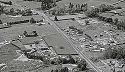 Motumaoho on 22 Jan 1968 | |
 Motumaoho | |
| Coordinates: 37.691264°S 175.470972°E | |
| Country | |
| Region | Waikato |
| Territorial authority | Matamata-Piako District |
| Ward | Morrinsville |
| Electorate | Waikato |
| Elevation | 30 m (100 ft) |
| Population (2013) | |
| • Total | 78 |
| Time zone | UTC+12 (NZST) |
| • Summer (DST) | UTC+13 (NZDT) |
| Postcode | 3372 |
| Area code(s) | 07 |
It once had a cheese factory, post office, railway station and garage,[5] but now has only greenhouses, a school and houses.[6] A hall was open in 1917 https://paperspast.natlib.govt.nz/newspapers/WT19170220.2.36
History
The area was sparsely occupied by Ngāti Werewere of Ngāti Hauā.[9] The nearest known archaeological site[10] is just over the confiscation line and county boundary, about 5km towards Eureka, where a ringditch pā, Mangao Tupua, is on a small knoll at the foot of the Pakaroa Range.[11]
Some early European traders are believed to have traversed the district prior to 1834, when the missionary, John Morgan, travelled up the Piako River and crossed to Horotiu. The 1860s saw an influx of European settlers to the area and, on 13 December 1873, a settler from Auckland, Thomas Morrin, purchased Kuranui No.1 Block.[12] In May 1874, he bought two further blocks, Motumaoho No.1 and No.2, and hired Irish navvies from the gold fields to dig a network of ditches to drain the land, enabling it to be used for agriculture.[13] In 1873 Motumaoho was described as being near Hangawera, a hill over 10km to the north, there being no other settlements in the area.[14]
The other large holding in the area was Norfolk Downs. That estate was divided into smaller farms about 1911, after which there was some growth in the population.[15]
Motumaoho Swamp
A 1963 study found much of the vegetation on Motumaoho swamp, to the north of the railway, remained as it had when it built up the peat bogs over about 13,000 years, the two dominant species being giant wire rush and wire rush.[16] However, since then, additional drains have been put in and, by 1998, Valentine Rd had been extended across the area.[17] The study also looked at Moanatuatua swamp, which became a scientific reserve in 1980.[18] Floods still occur.[19]
Cheese factory
The centre of the village is dominated by the former cheese factory. A New Zealand Dairy Association dairy was built in 1910.[20] The cheese factory was described as new in 1912, saying the Waikato Dairy Association's offer to build and run it was accepted.[21] However, in 1929 the cheese factory had on its wall - Norfolk Coop Dairy Co estd. 1916.[22] The Norfolk Co-operative Dairy Company was formed in 1915,[23] with 22 suppliers.[24] Electric power was connected in 1923, when a new factory was approved.[15] It was working by 1924.[25] Norfolk Co-operative Dairy Company, Limited merged into Morrinsville Co-operative Dairy Company, Limited in 1946.[26] The factory closed in 1983.[27] The derelict building remains and, between 2010[28] and 2014, a rusting Bedford OB bus was parked beside it.[29]
Flax
In 1926 Palmerston North-based flax miller, Fred Seifert,[30] formed a company to develop[31] 4,000 acres (1,600 ha) of former dairy and scrubland north of Motumaoho. He hoped to build a mill in 1929,[32] but an old flax mill was demolished in 1928[8] and a shareholders tour in 1929[33] failed to raise capital, so no more was heard of the prothe eastect.[34]
Demographics
By 1891 41 people were living in Motumaoho[36] and, though the 1896 census recorded only 7,[37] 215 were in the 1916 census.[38] The current population has shrunk, the main part of the village, near the old dairy, being in meshblock 1091200, which had these census figures[39] -
| Year | Population | Median age | Households | Median income | National median |
|---|---|---|---|---|---|
| 2001 | 87 | 26.5 | 27 | $17,500 | $18,500 |
| 2006 | 96 | 27 | 30 | $25,800 | $24,100 |
| 2013 | 78 | 32.2 | 27 | $36,300 | $27,900 |
Education
Motumaoho School is on SH26.[40] It had a roll of 33 in 2017[41] and has 3 teachers.[42] In 1923 it had 70 children.[43]
A request for a school was made in Parliament in 1910[44] and a one roomed school opened in 1912. In 1969 it was replaced by a school with a small library and a staff-room transported from Ohautira. Later changes added a library, which had been the Post Office, and a front deck.[27]
Commerce
Agriculture, at 56.9%, was the main occupation in 2013 in Tahuroa census area (to the west of Morrinsville, including Motumaoho).[45]
Quarry
The only other significant remaining occupation is quarrying. At the end of Harbottle Road, on the slopes of the Pakaroa Range, about 4 km (2.5 mi) south of Motumaoho,[46] Winstone Aggregates supplies road stone.[47] The quarry contains the index fossil, minotis, dating from the middle Jurassic, Norian age.[48] The quarry was first developed for road stone by Piako County Council in 1924[49] on land they leased.[50]
Transport
Road
SH26 through the village was sealed in about 1929.[51] Traffic volumes have increased from 4,397 in 2008 to 4,812 in 2015.[52]
Railway
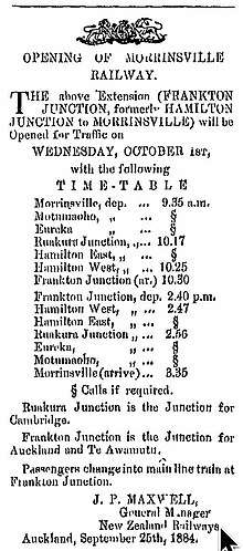
Motumaoho railway station was a flag station on the East Coast Main Trunk line, about 3 km (1.9 mi) north of the village.[53] It opened on 1 October 1884 and closed to passengers on 31 July 1967 and to goods on 27 May 1973.[54] It had a goods shed and cattle yard,[55] the latter built after 1936.[56] The line is on a rising gradient from Morrinsville.[57]
| Preceding station | Historical railways | Following station | ||
|---|---|---|---|---|
| Eureka Line open, station closed |
East Coast Main Trunk New Zealand Railways Department |
Morrinsville Line open, station closed | ||
Incidents
On 6 August 1959 Leslie George Kelly,[58] an engine driver and Māori author, was killed in a head-on collision at Motumaoho.[59]
Notable people
Joan Hart, sprinter at the 1950 British Empire Games
See also
Neighbouring areas | |
|---|---|
References
- "Hamilton to SH 26 (near Norfolk Rd) (hail2ride)". Google maps. Retrieved 2020-04-11.
- "Morrinsville to SH 26 (near Norfolk Rd) (hail2ride)". Google maps. Retrieved 2020-04-11.
- "NZGB Gazetteer". gazetteer.linz.govt.nz. Retrieved 2020-04-11.
- "1000 Māori place names - Te Wiki o Te Reo Māori - Māori Language Week". nzhistory.govt.nz. Retrieved 2020-04-11.
- "Couple trick fleeing teens, delivering them to waiting police". Stuff. Retrieved 2020-04-11.
- "Motumaoho District Plan map" (PDF). Matamata-Piako District Council. 11 Oct 2019.
- "WOMEN'S WORLD - WAIKATO TIMES". paperspast.natlib.govt.nz. 12 Sep 1925. Retrieved 2020-04-11.
- "MOTUMAOHO. WAIKATO TIMES". paperspast.natlib.govt.nz. 15 Aug 1928. Retrieved 2020-04-11.
- "Morrinsville History". www.mpdc.govt.nz. Retrieved 2020-04-12.
- "NZAA Site Viewer". archsite.eaglegis.co.nz. Retrieved 2020-04-13.
- "Proposed District Plan (Stage 1) Schedule 30.3 Maaori Sites of Significance" (PDF). Waikato District Council. 18 July 2018.
- "Land Title; 1876; 7042 - Morrinsville Museum on NZMuseums". www.nzmuseums.co.nz. Retrieved 2016-03-02.
- "Morrinsville History". www.mpdc.govt.nz. Retrieved 2020-04-11.
- "The Daily Southern Cross". paperspast.natlib.govt.nz. 30 Oct 1873. Retrieved 2020-04-12.
- "PROGRESSIVE WAIKATO - WAIKATO TIMES". paperspast.natlib.govt.nz. 24 Nov 1923. Retrieved 2020-04-12.
- "The Restiad Peat Bogs at Motumaoho and Moanatuatua TRANSACTIONS OF THE ROYAL SOCIETY OF NEW ZEALAND : BOTANY". paperspast.natlib.govt.nz. 14 Feb 1964. Retrieved 2020-04-11.
- "Sheet: S14". www.mapspast.org.nz. 1998. Retrieved 2020-04-11.
- "THE NEW ZEALAND GAZETTE" (PDF).
- D70 (2010-02-01), Floods from summer rains, retrieved 2020-04-11
- "LOCAL AND GENERAL. WAIKATO INDEPENDENT". paperspast.natlib.govt.nz. 31 May 1910. Retrieved 2020-04-11.
- "NEW CHEESE FACTORY WAIKATO ARGUS". paperspast.natlib.govt.nz. 18 Dec 1912. Retrieved 2020-04-13.
- "DISTRICT NEWS WAIKATO TIMES". paperspast.natlib.govt.nz. 7 Dec 1929. Retrieved 2020-04-13.
- Hart, Philip (2016). "Te Aroha Mining District Working Papers No. 102" (PDF). University of Waikato.
- "COUNTRY NEWS. NEW ZEALAND HERALD". paperspast.natlib.govt.nz. 27 May 1915. Retrieved 2020-04-13.
- "NORFOLK DAIRY COMPANY. WAIKATO TIMES". paperspast.natlib.govt.nz. 9 Sep 1924. Retrieved 2020-04-12.
- "New Zealand Gazette 1947" (PDF).
- "Motumaoho School and District Centenary". www.schoolandcollegelistings.com. Retrieved 2020-04-11.
- "15 Norfolk Rd". Google Maps. Retrieved 2020-04-11.
- "15 Norfolk Rd". Google Maps. Retrieved 2020-04-11.
- Taonga, New Zealand Ministry for Culture and Heritage Te Manatu. "Seifert, Alfred". teara.govt.nz. Retrieved 2020-04-11.
- "Page 1 Advertisements Column 3 THAMES STAR". paperspast.natlib.govt.nz. 18 June 1926. Retrieved 2020-04-11.
- "NEW ZEALAND FLAX. NEW ZEALAND HERALD". paperspast.natlib.govt.nz. 7 June 1927. Retrieved 2020-04-11.
- "FLAX GROWING. WAIKATO TIMES". paperspast.natlib.govt.nz. 22 April 1929. Retrieved 2020-04-11.
- McLintock, Alexander Hare; Brian Newton Davis, M. A.; Taonga, New Zealand Ministry for Culture and Heritage Te Manatu. "MORRINSVILLE". An encyclopaedia of New Zealand, edited by A. H. McLintock, 1966. Retrieved 2020-04-12.
- "J. B. Chapman Soap Manufacturer (Motumaoho)". paperspast.natlib.govt.nz. 21 Dec 1921. Retrieved 2020-04-12.
- "1891 census".
- "Results Of A Census Of The Colony Of New Zealand taken for the night of 12th April 1896". StatsNZ.
- "REPORT ON THE RESULTS OF A CENSUS OF THE POPULATION OF THE DOMINION OF NEW ZEALAND TAKEN FOR THE NIGHT OF THE 15th OCTOBER, 1916". www3.stats.govt.nz. Retrieved 2020-04-11.
- "2013 Census map – QuickStats about a place". archive.stats.govt.nz. Retrieved 2018-05-30.
- "Motumaoho School Ministry of Education School Profile". educationcounts.govt.nz. Ministry of Education.
- "Motumaoho School - 15/06/2017". Education Review Office. Retrieved 2020-04-11.
- "Our Staff". Motumaoho School. Retrieved 2020-04-13.
- "PROGRESSIVE WAIKATO - WAIKATO TIMES". paperspast.natlib.govt.nz. 28 Nov 1923. Retrieved 2020-04-12.
- Parliament, New Zealand (1910). Parliamentary Debates: House of Representatives.
- "2013 Census QuickStats about a place". archive.stats.govt.nz. Retrieved 2020-04-12.
- "Motumaoho, Waikato". NZ Topo Map. Retrieved 2020-04-11.
- "Suppliers of Surfacing Aggregate" (PDF). NZTA. 2004.
- Speden, Ian G. (January 1976). "Fossil localities in Torlesse rocks of the North Island, New Zealand". Journal of the Royal Society of New Zealand. 6 (1): 73–91. doi:10.1080/03036758.1976.10421467. ISSN 0303-6758.
- "PIAKO COUNTY COUNCIL - WAIKATO TIMES". paperspast.natlib.govt.nz. 20 Aug 1924. Retrieved 2020-04-13.
- "PIAKO COUNTY. WAIKATO TIMES". paperspast.natlib.govt.nz. 18 June 1929. Retrieved 2020-04-13.
- "PIAKO COUNTY. WAIKATO TIMES". paperspast.natlib.govt.nz. 18 June 1929. Retrieved 2020-04-13.
- "Traffic Counts New Zealand - Abley". www.trafficcounts.co.nz. Retrieved 2020-04-13.
- "Sheet: N56". www.mapspast.org.nz. 1944. Retrieved 2020-04-11.
- Scoble, Juliet (2010). "Names & Opening & Closing Dates of Railway Stations" (PDF). Rail Heritage Trust of New Zealand.
- "Stations". NZR Rolling Stock Lists. Retrieved 2020-04-11.
- "FARMERS' UNION. AUCKLAND STAR". paperspast.natlib.govt.nz. 11 Nov 1936. Retrieved 2020-04-11.
- Headed into the late afternoon sun at Motumaoho, 16 Aug 2016, retrieved 2020-04-11
- "Journal of the Polynesian Society: Leslie G. Kelly - Te Putu, P 57-60". www.jps.auckland.ac.nz. Retrieved 2020-04-11.
- Department, Maori Affairs (1959-12-01). "LESLIE GEORGE KELLY - (Te Ao Hou - No. 29 December 1959)". Te Ao Hou - No. 29 (December 1959). Retrieved 2020-04-11.
- "22 Morrinsville/Paeroa". busit.co.nz. Retrieved 2020-04-12.
- "Kurunui Rd". Google Maps. Retrieved 2020-04-11.
- "Thresholds map" (PDF). First Gas.