Morrowville, Kansas
Morrowville is a city in Washington County, Kansas, United States. As of the 2010 census, the city population was 155.[6]
Morrowville, Kansas | |
|---|---|
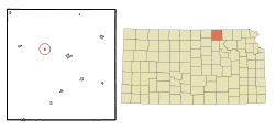 Location within Washington County and Kansas | |
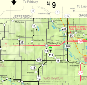 KDOT map of Washington County (legend) | |
| Coordinates: 39°50′38″N 97°10′20″W | |
| Country | United States |
| State | Kansas |
| County | Washington |
| Founded | 1884 |
| Incorporated | 1929 |
| Named for | James Morrow |
| Area | |
| • Total | 0.14 sq mi (0.36 km2) |
| • Land | 0.14 sq mi (0.36 km2) |
| • Water | 0 sq mi (0 km2) |
| Elevation | 1,348 ft (411 m) |
| Population | |
| • Total | 155 |
| • Estimate (2016)[3] | 148 |
| • Density | 1,100/sq mi (430/km2) |
| Time zone | UTC-6 (CST) |
| • Summer (DST) | UTC-5 (CDT) |
| ZIP code | 66958 |
| Area code | 785 |
| FIPS code | 20-48450 [4] |
| GNIS ID | 0472873 [5] |
History
Morrowville was laid out and platted in 1884 when it was certain that the Missouri and Burlington Railroad would be extended to that point. It was named for its founder, James C. Morrow.[7]
The first post office in Morrowville was established in 1884, but the post office was called Morrow Station until 1894.[8]
Geography
Morrowville is located at 39°50′38″N 97°10′20″W (39.843829, -97.172337).[9] According to the United States Census Bureau, the city has a total area of 0.14 square miles (0.36 km2), all of it land.[1]
Area attractions
Demographics
| Historical population | |||
|---|---|---|---|
| Census | Pop. | %± | |
| 1930 | 246 | — | |
| 1940 | 308 | 25.2% | |
| 1950 | 229 | −25.6% | |
| 1960 | 195 | −14.8% | |
| 1970 | 201 | 3.1% | |
| 1980 | 180 | −10.4% | |
| 1990 | 173 | −3.9% | |
| 2000 | 168 | −2.9% | |
| 2010 | 155 | −7.7% | |
| Est. 2016 | 148 | [3] | −4.5% |
| U.S. Decennial Census | |||
2010 census
As of the census[2] of 2010, there were 155 people, 60 households, and 42 families residing in the city. The population density was 1,107.1 inhabitants per square mile (427.5/km2). There were 90 housing units at an average density of 642.9 per square mile (248.2/km2). The racial makeup of the city was 98.7% White and 1.3% from two or more races.
There were 60 households of which 38.3% had children under the age of 18 living with them, 65.0% were married couples living together, 1.7% had a female householder with no husband present, 3.3% had a male householder with no wife present, and 30.0% were non-families. 26.7% of all households were made up of individuals and 13.3% had someone living alone who was 65 years of age or older. The average household size was 2.58 and the average family size was 3.05.
The median age in the city was 40.4 years. 28.4% of residents were under the age of 18; 5.2% were between the ages of 18 and 24; 23.2% were from 25 to 44; 24.5% were from 45 to 64; and 18.7% were 65 years of age or older. The gender makeup of the city was 52.3% male and 47.7% female.
2000 census
As of the census[4] of 2000, there were 168 people, 73 households, and 44 families residing in the city. The population density was 1,187.4 people per square mile (463.3/km²). There were 93 housing units at an average density of 657.3 per square mile (256.5/km²). The racial makeup of the city was 98.21% White, 1.19% Native American, and 0.60% from two or more races. Hispanic or Latino of any race were 0.60% of the population.
There were 73 households out of which 27.4% had children under the age of 18 living with them, 54.8% were married couples living together, 2.7% had a female householder with no husband present, and 38.4% were non-families. 38.4% of all households were made up of individuals and 26.0% had someone living alone who was 65 years of age or older. The average household size was 2.30 and the average family size was 3.09.
In the city, the population was spread out with 28.0% under the age of 18, 1.8% from 18 to 24, 25.0% from 25 to 44, 17.3% from 45 to 64, and 28.0% who were 65 years of age or older. The median age was 40 years. For every 100 females, there were 90.9 males. For every 100 females age 18 and over, there were 95.2 males.
The median income for a household in the city was $26,786, and the median income for a family was $32,500. Males had a median income of $22,813 versus $16,250 for females. The per capita income for the city was $12,133. About 4.8% of families and 9.1% of the population were below the poverty line, including 15.9% of those under the age of eighteen and 7.4% of those sixty five or over.
Education
It is within Washington County USD 108,[13] which formed in 2006 by the consolidation of North Central USD 221 and Washington USD 222.[14] The Washington County High School mascot is Tigers. [15]
School unification consolidated Morrowville and Haddam schools into USD #221 schools in 1967. The high school was in Morrowville. The grade school in Haddam. The district was USD #221 and was called North Central. In the mid 1970s Mahaska grade school also joined USD 221.
The North Central High School mascot was the North Central Cougars.[16]
References
- "US Gazetteer files 2010". United States Census Bureau. Archived from the original on 2012-01-25. Retrieved 2012-07-06.
- "U.S. Census website". United States Census Bureau. Retrieved 2012-07-06.
- "Population and Housing Unit Estimates". Retrieved June 9, 2017.
- "U.S. Census website". United States Census Bureau. Retrieved 2008-01-31.
- "US Board on Geographic Names". United States Geological Survey. 2007-10-25. Retrieved 2008-01-31.
- "2010 City Population and Housing Occupancy Status". U.S. Census Bureau. Retrieved November 3, 2011.
- "100 Year History of Morrowville, Kansas". Blue Skyways. State Library of Kansas. Archived from the original on January 24, 2012. Retrieved 27 June 2014.CS1 maint: unfit url (link)
- "Kansas Post Offices, 1828-1961, page 2". Kansas Historical Society. Archived from the original on October 9, 2013. Retrieved 27 June 2014.CS1 maint: unfit url (link)
- "US Gazetteer files: 2010, 2000, and 1990". United States Census Bureau. 2011-02-12. Retrieved 2011-04-23.
- Patent 1522378, Attachment For Tractors, John E McLeod and James D Cummings, Filed December 18, 1923.
- "World's First Bulldozer". Retrieved 2008-03-01.
- Morrowville, Kansas - Home of the World's First Bulldozer
- "USD 108 Map" (PDF). Kansas Department of Transportation. Retrieved 2020-04-29.
- "School consolidations in Kansas for past decade". The Topeka Capital-Journal. 2011-07-24. Retrieved 2020-04-26.
- "Washington Co. USD 108". USD 108. Retrieved 1 January 2017.
- "North Central Wins District", The Belleville Telescope, 8 March 1973, p.7.
External links
- City
- Schools
- USD 108, local school district
- Maps
- Washington County Map, KDOT
Municipalities and communities of Washington County, Kansas, United States | ||
|---|---|---|
| Cities | 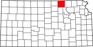 Map of Kansas highlighting Washington County | |
| Unincorporated communities | ||
| Footnotes | ‡This populated place also has portions in an adjacent county or counties | |