Clifton, Kansas
Clifton is a city in Washington and Clay counties in the U.S. state of Kansas. As of the 2010 census, the city population was 554.[6]
Clifton, Kansas | |
|---|---|
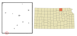 Location within Washington County and Kansas | |
 KDOT map of Washington County (legend) | |
| Coordinates: 39°34′1″N 97°16′48″W | |
| Country | United States |
| State | Kansas |
| Counties | Washington, Clay |
| Founded | 1870 |
| Incorporated | 1884 |
| Area | |
| • Total | 0.41 sq mi (1.06 km2) |
| • Land | 0.41 sq mi (1.06 km2) |
| • Water | 0 sq mi (0 km2) |
| Elevation | 1,302 ft (397 m) |
| Population | |
| • Total | 554 |
| • Estimate (2018)[3] | 509 |
| • Density | 1,400/sq mi (520/km2) |
| Time zone | UTC-6 (CST) |
| • Summer (DST) | UTC-5 (CDT) |
| ZIP code | 66937 |
| Area code | 785 |
| FIPS code | 20-14200 [4] |
| GNIS ID | 0473360 [5] |
History
Clifton was founded in 1870, and bears the name of a surveyor who had platted the original town in 1859.[7][lower-alpha 1]
Clifton was an important shipping point located at the junction of three railroads.[10]
Geography
Clifton is located at 39°34′1″N 97°16′48″W (39.567063, -97.279982).[11] According to the United States Census Bureau, the city has a total area of 0.41 square miles (1.06 km2), all of it land.[1] The city is located next to Vining.
Demographics
| Historical population | |||
|---|---|---|---|
| Census | Pop. | %± | |
| 1880 | 142 | — | |
| 1890 | 622 | 338.0% | |
| 1900 | 609 | −2.1% | |
| 1910 | 614 | 0.8% | |
| 1920 | 631 | 2.8% | |
| 1930 | 713 | 13.0% | |
| 1940 | 670 | −6.0% | |
| 1950 | 743 | 10.9% | |
| 1960 | 746 | 0.4% | |
| 1970 | 718 | −3.8% | |
| 1980 | 695 | −3.2% | |
| 1990 | 492 | −29.2% | |
| 2000 | 557 | 13.2% | |
| 2010 | 554 | −0.5% | |
| Est. 2018 | 509 | [3] | −8.1% |
| U.S. Decennial Census | |||
2010 census
As of the census[2] of 2010, there were 554 people, 232 households, and 145 families residing in the city. The population density was 1,351.2 inhabitants per square mile (521.7/km2). There were 262 housing units at an average density of 639.0 per square mile (246.7/km2). The racial makeup of the city was 98.6% White, 0.4% African American, 0.2% Native American, 0.5% from other races, and 0.4% from two or more races. Hispanic or Latino of any race were 1.1% of the population.
There were 232 households of which 26.3% had children under the age of 18 living with them, 53.9% were married couples living together, 5.6% had a female householder with no husband present, 3.0% had a male householder with no wife present, and 37.5% were non-families. 34.5% of all households were made up of individuals and 19.8% had someone living alone who was 65 years of age or older. The average household size was 2.30 and the average family size was 2.99.
The median age in the city was 46 years. 22.4% of residents were under the age of 18; 7.3% were between the ages of 18 and 24; 18.5% were from 25 to 44; 26.9% were from 45 to 64; and 25.1% were 65 years of age or older. The gender makeup of the city was 48.7% male and 51.3% female.
2000 census
As of the census[4] of 2000, there were 557 people, 240 households, and 149 families residing in the city. The population density was 1,378.7 people per square mile (537.6/km²). There were 278 housing units at an average density of 688.1 per square mile (268.3/km²). The racial makeup of the city was 98.74% White, 0.54% Native American, and 0.72% from two or more races.
There were 240 households out of which 28.8% had children under the age of 18 living with them, 52.1% were married couples living together, 6.7% had a female householder with no husband present, and 37.9% were non-families. 35.4% of all households were made up of individuals and 22.5% had someone living alone who was 65 years of age or older. The average household size was 2.32 and the average family size was 3.06.
In the city, the population was spread out with 26.6% under the age of 18, 7.5% from 18 to 24, 21.9% from 25 to 44, 20.1% from 45 to 64, and 23.9% who were 65 years of age or older. The median age was 39 years. For every 100 females, there were 86.3 males. For every 100 females age 18 and over, there were 77.8 males.
The median income for a household in the city was $21,750, and the median income for a family was $34,375. Males had a median income of $26,458 versus $16,167 for females. The per capita income for the city was $13,962. About 16.2% of families and 21.0% of the population were below the poverty line, including 26.1% of those under age 18 and 28.5% of those age 65 or over.
Education
Clifton is part of the Clifton-Clyde Unified School District 224.[12] The school district includes Clifton, Clyde, Vining, Ames, St. Joseph, and nearby rural areas of Clay, Cloud, Republic, Washington counties. The district has three schools:
- Clifton-Clyde Senior High School, located in Clyde.
- Clifton-Clyde Middle School, located in Clifton.
- Clifton-Clyde Grade School, located in Clifton.
The Clifton-Clyde High School mascot is Eagles. Prior to school unification in 1981, the Clifton High School mascot was Cardinals.[13]
The Clifton Cardinals won the Kansas State High School class 1A Football championship in 1969.[14]
Notable people
- William Henderson, painter, architect, and furniture designer.
- Robert McAlmon, author, poet, and publisher.
Notes
- The first building erected in the original town was a one-room log hut that served the pioneers who settled there as a fort during troubled times between them and the area's Indians. Clifton and Fort Clifton ended up occupying several locations.[8] In 1860 Clifton was moved just to the north and ended up just inside Washington County, Kansas. A number of log cabins were built there by the settlers, so they could take refuge there during Indian uprisings. In 1861 and 1862 school was held in one of the cabins.[9]
References
- "US Gazetteer files 2010". United States Census Bureau. Archived from the original on 2012-07-02. Retrieved 2012-07-06.
- "U.S. Census website". United States Census Bureau. Retrieved 2012-07-06.
- "Population and Housing Unit Estimates". Retrieved March 14, 2020.
- "U.S. Census website". United States Census Bureau. Retrieved 2008-01-31.
- "US Board on Geographic Names". United States Geological Survey. 2007-10-25. Retrieved 2008-01-31.
- "2010 City Population and Housing Occupancy Status". U.S. Census Bureau. Retrieved November 3, 2011.
- Kansas State Historical Society (1916). Biennial Report of the Board of Directors of the Kansas State Historical Society. Kansas State Printing Plant. pp. 312.
- Ned ___, "History of Clay County by Townships," The Times (Clay Center, Kans.), May 18, 1882, p. 1; E. Neil Carson, letter to William C. Pollard, Jr., August 31, 1992, p. 1; Pollard, "Military Forts and Posts in Kansas: 1854-1865" (Ph.D. dissertation, Faith Baptist College and Seminary, 1997), pp.41, 123; Carson, letter to Pollard, September 9, 1992, p. 3; Clarence M. Burk, "Early Clifton Had Several Locations," The Times, October 27, 1966, p. 1; "Fort What?," Clifton News-Tribune, June 18, 1981, p. 12.
- Burk, p. 1; "Fort What?," p. 12.
- Blackmar, Frank Wilson (1912). Kansas: A Cyclopedia of State History, Embracing Events, Institutions, Industries, Counties, Cities, Towns, Prominent Persons, Etc. Standard Publishing Company. pp. 367.
- "US Gazetteer files: 2010, 2000, and 1990". United States Census Bureau. 2011-02-12. Retrieved 2011-04-23.
- USD 224
- "Falcons, Bulldogs, Wildcats, Tigers victors in BVL play", The Manhattan Mercury, 4 February 1973, p.7.
- "Football". KSHSAA. Retrieved 3 January 2017.
External links
- City
- Schools
- Clifton-Clyde USD 224, local school district
- Maps
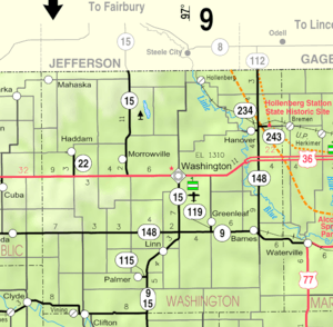
- Clifton City Map, KDOT
Municipalities and communities of Clay County, Kansas, United States | ||
|---|---|---|
| Cities | 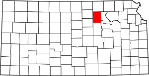 Map of Kansas highlighting Clay County | |
| Unincorporated communities | ||
| Ghost towns | ||
| Townships | ||
| Footnotes | ‡This populated place also has portions in an adjacent county or counties | |
Municipalities and communities of Washington County, Kansas, United States | ||
|---|---|---|
| Cities |  Map of Kansas highlighting Washington County | |
| Unincorporated communities | ||
| Footnotes | ‡This populated place also has portions in an adjacent county or counties | |