Morrovalle
Morrovalle is a comune (municipality) in the Province of Macerata in the Italian region Marche, located about 35 kilometres (22 mi) south of Ancona and about 11 kilometres (7 mi) east of Macerata.
Morrovalle | |
|---|---|
| Comune di Morrovalle | |
 A view of historical center of Morrovalle from "colli bella vista" (Nice view hills) | |
Location of Morrovalle 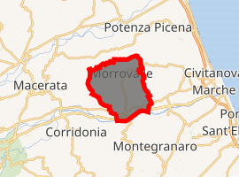
| |
 Morrovalle Location of Morrovalle in Italy 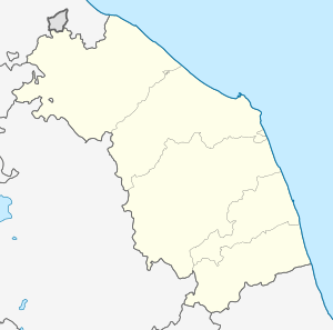 Morrovalle Morrovalle (Marche) | |
| Coordinates: 43°19′N 13°35′E | |
| Country | Italy |
| Region | Marche |
| Province | Macerata (MC) |
| Frazioni | Borgo Pintura, Morrovalle Scalo, Padri Passionisti, Cunicchio, Santa Lucia, Trodica, Mulinetto |
| Government | |
| • Mayor | Stefano Montemarani |
| Area | |
| • Total | 42.58 km2 (16.44 sq mi) |
| Elevation | 246 m (807 ft) |
| Population (30 November 2017)[2] | |
| • Total | 10,069 |
| • Density | 240/km2 (610/sq mi) |
| Demonym(s) | Morrovallesi |
| Time zone | UTC+1 (CET) |
| • Summer (DST) | UTC+2 (CEST) |
| Postal code | 62010 |
| Dialing code | 0733 |
| Patron saint | St. Bartholomew the Apostle |
| Saint day | August 24 |
| Website | Official website |
Morrovalle borders the following municipalities: Corridonia, Macerata, Monte San Giusto, Montecosaro, Montegranaro, Montelupone.
Main sights
- Church of Sant'Agostino
- Church of San Bartolomeo
- Sanctuary of Madonna dell'Acqua Santa
References
- "Superficie di Comuni Province e Regioni italiane al 9 ottobre 2011". Istat. Retrieved 16 March 2019.
- All demographics and other statistics: Italian statistical institute Istat.
External links
This article is issued from Wikipedia. The text is licensed under Creative Commons - Attribution - Sharealike. Additional terms may apply for the media files.