Morris Township, Huntingdon County, Pennsylvania
Morris Township is a township in Huntingdon County, Pennsylvania, United States. The population was 410 at the 2010 census.[3]
Morris Township, Huntingdon County, Pennsylvania | |
|---|---|
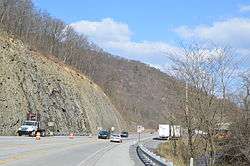 U.S. Route 22 in eastern Morris Township | |
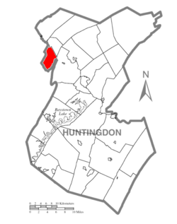 Map of Huntingdon County, Pennsylvania Highlighting Morris Township | |
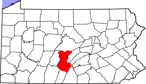 Map of Huntingdon County, Pennsylvania | |
| Country | United States |
| State | Pennsylvania |
| County | Huntingdon |
| Area | |
| • Total | 12.15 sq mi (31.48 km2) |
| • Land | 12.15 sq mi (31.48 km2) |
| • Water | 0.00 sq mi (0.00 km2) |
| Population (2010) | |
| • Total | 410 |
| • Estimate (2016)[2] | 419 |
| • Density | 34.47/sq mi (13.31/km2) |
| Time zone | UTC-5 (Eastern (EST)) |
| • Summer (DST) | UTC-4 (EDT) |
| Zip code | 16611 |
| Area code(s) | 814 |
| FIPS code | 42-061-51080 |
| Local phone exchanges: 669, 832 | |
Geography
According to the United States Census Bureau, the township has a total area of 12.1 square miles (31.3 km²), all of it land.
Demographics
| Historical population | |||
|---|---|---|---|
| Census | Pop. | %± | |
| 2000 | 416 | — | |
| 2010 | 410 | −1.4% | |
| Est. 2016 | 419 | [2] | 2.2% |
| U.S. Decennial Census[4] | |||
At the 2000 census there were 416 people in 138 households, including 117 families, in the township. The population density was 34.4 people per square mile (13.3/km²). There were 158 housing units at an average density of 13.1/sq mi (5.0/km²). The racial makeup of the township was 97.60% White, 2.16% from other races, and 0.24% from two or more races. Hispanic or Latino of any race were 2.16%.[5]
There were 138 households, 42.8% had children under the age of 18 living with them, 73.9% were married couples living together, 4.3% had a female householder with no husband present, and 15.2% were non-families. 12.3% of households were made up of individuals, and 4.3% were one person aged 65 or older. The average household size was 3.01 and the average family size was 3.26.
The age distribution was 31.5% under the age of 18, 6.5% from 18 to 24, 28.8% from 25 to 44, 23.8% from 45 to 64, and 9.4% 65 or older. The median age was 36 years. For every 100 females there were 114.4 males. For every 100 females age 18 and over, there were 109.6 males.
The median household income was $38,125 and the median family income was $40,417. Males had a median income of $31,625 versus $22,500 for females. The per capita income for the township was $14,314. About 6.3% of families and 11.7% of the population were below the poverty line, including 17.5% of those under age 18 and 5.7% of those age 65 or over.
Recreation
A small portion of Pennsylvania State Game Lands Number 166 is located on Brush Mountain in the western portion of the township.[6]
References
- "2016 U.S. Gazetteer Files". United States Census Bureau. Retrieved Aug 14, 2017.
- "Population and Housing Unit Estimates". Retrieved June 9, 2017.
- "U.S. Census website". United States Census Bureau. Retrieved 2017-03-04.
- "Census of Population and Housing". Census.gov. Retrieved June 4, 2016.
- "U.S. Census website". United States Census Bureau. Retrieved 2008-01-31.
- Pennsylvania State Game Lands Number 166, retrieved 14 November 2018
Municipalities and communities of Huntingdon County, Pennsylvania, United States | ||
|---|---|---|
| Boroughs | | |
| Townships | ||
| CDPs | ||
| Unincorporated communities | ||
| Ghost town | ||
| Footnotes | ‡This populated place also has portions in an adjacent county or counties | |