Montelaterone
Montelaterone (Italian: [ˌmontelateˈroːne]) is a village in Tuscany, central Italy, administratively a frazione of the comune of Arcidosso, province of Grosseto, in the area of Mount Amiata. At the time of the 2001 census its population amounted to 283.[1]
Montelaterone | |
|---|---|
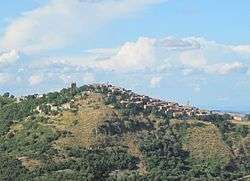 View of Montelaterone from Zancona | |
 Montelaterone Location of Montelaterone in Italy | |
| Coordinates: 42°53′15″N 11°30′45″E | |
| Country | |
| Region | |
| Province | Grosseto (GR) |
| Comune | Arcidosso |
| Elevation | 670 m (2,200 ft) |
| Population (2001) | |
| • Total | 283 |
| Demonym(s) | Montelateronesi |
| Time zone | UTC+1 (CET) |
| • Summer (DST) | UTC+2 (CEST) |
| Postal code | 58030 |
| Dialing code | 0564 |
Montelaterone is about 52 km from Grosseto and 4 km from Arcidosso, and it is situated on a sandstone peak between the valleys of Ente and Zancona rivers.
Main sights
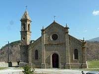
The old pieve of Santa Maria a Lamula
- Church of San Clemente (14th century), main parish church of the village
- Church of Madonna della Misericordia (17th century), with frescoes by Francesco and Giuseppe Nicola Nasini
- Chapel of Santa Lucia in Stiacciaie (14th century)
- Pieve of Santa Maria a Lamula (12th century), between Montelaterone and Arcidosso, it is an important and ancient Romanesque church.
- Palazzo Pretorio (13th century), ancient city hall
- Walls of Montelaterone, old fortifications which surround the village since 11th century
- Cassero Senese, a 13th-century fortress
References
- (in Italian) Popolazione residente - Grosseto (dettaglio loc. abitate) - Censimento 2001, Istat.
Bibliography
- Aldo Mazzolai, Guida della Maremma. Percorsi tra arte e natura, Le Lettere, Florence, 1997
- Giuseppe Guerrini, Torri e castelli della Provincia di Grosseto, Nuova Immagine Editrice, Siena, 1999
This article is issued from Wikipedia. The text is licensed under Creative Commons - Attribution - Sharealike. Additional terms may apply for the media files.