Montaut, Haute-Garonne
Montaut is a commune in the Haute-Garonne department of southwestern France.
Montaut | |
|---|---|
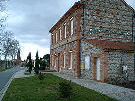 Town hall | |
 Coat of arms | |
Location of Montaut 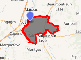
| |
 Montaut  Montaut | |
| Coordinates: 43°21′22″N 1°17′28″E | |
| Country | France |
| Region | Occitanie |
| Department | Haute-Garonne |
| Arrondissement | Muret |
| Canton | Auterive |
| Intercommunality | Volvestre |
| Government | |
| • Mayor (2001–2008) | Robert Delmas |
| Area 1 | 17.88 km2 (6.90 sq mi) |
| Population (2017-01-01)[1] | 506 |
| • Density | 28/km2 (73/sq mi) |
| Time zone | UTC+01:00 (CET) |
| • Summer (DST) | UTC+02:00 (CEST) |
| INSEE/Postal code | 31361 /31410 |
| Elevation | 175–301 m (574–988 ft) (avg. 319 m or 1,047 ft) |
| 1 French Land Register data, which excludes lakes, ponds, glaciers > 1 km2 (0.386 sq mi or 247 acres) and river estuaries. | |
Geography
The Lèze flows north through the eastern part of the commune and forms part of its northeastern border.
The Garonne forms part of the commune's western border.
Population
| Historical population | ||
|---|---|---|
| Year | Pop. | ±% |
| 1962 | 234 | — |
| 1968 | 250 | +6.8% |
| 1975 | 316 | +26.4% |
| 1982 | 362 | +14.6% |
| 1990 | 374 | +3.3% |
| 1999 | 440 | +17.6% |
| 2008 | 511 | +16.1% |
References
- "Populations légales 2017". INSEE. Retrieved 6 January 2020.
| Wikimedia Commons has media related to Montaut (Haute-Garonne). |
| Authority control |
|
|---|
This article is issued from Wikipedia. The text is licensed under Creative Commons - Attribution - Sharealike. Additional terms may apply for the media files.