Barbazan, Haute-Garonne
Barbazan is a commune in the Haute-Garonne department in the Occitanie region of south-western France.
Barbazan | |
|---|---|
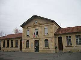 The town hall in Barbazan | |
.svg.png) Coat of arms | |
Location of Barbazan 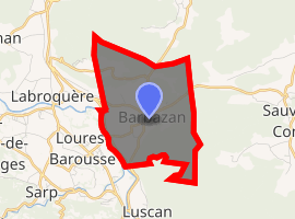
| |
 Barbazan  Barbazan | |
| Coordinates: 43°02′00″N 0°37′26″E | |
| Country | France |
| Region | Occitanie |
| Department | Haute-Garonne |
| Arrondissement | Saint-Gaudens |
| Canton | Bagnères-de-Luchon |
| Intercommunality | Haut Comminges |
| Government | |
| • Mayor (2014–2020) | Michelle Stradere |
| Area 1 | 6.05 km2 (2.34 sq mi) |
| Population (2017-01-01)[1] | 490 |
| • Density | 81/km2 (210/sq mi) |
| Time zone | UTC+01:00 (CET) |
| • Summer (DST) | UTC+02:00 (CEST) |
| INSEE/Postal code | 31045 /31510 |
| Elevation | 439–890 m (1,440–2,920 ft) (avg. 450 m or 1,480 ft) |
| 1 French Land Register data, which excludes lakes, ponds, glaciers > 1 km2 (0.386 sq mi or 247 acres) and river estuaries. | |
The inhabitants of the commune are known as Barbazanais or Barbazanaises.[2]
Geography
Barbazan is a Spa town in the Comminges region located some 13 km south-west of Saint-Gaudens and 12 km north of Cierp-Gaud. The western border of the commune is also the departmental border between Haute-Garonne and Hautes-Pyrénées. Access to the commune is by Route nationale N125 which comes from the end of the A645 autoroute and passes down the western side of the commune south to Ore. The D26E road comes from Labroquère in the north-west and passes through the north of the commune ending in the village. The D26 comes from Valcabrère in the west and passes through the village continuing to Sauveterre-de-Comminges in the east. The D33D and the D33L go south from the village to join the N125. The commune has extensive forests in the east with some farmland in the west.[3]
The Garonne river forms most of the western border of the commune as it flows north, passing through Toulouse, to eventually join the Dordogne to form the Gironde estuary at Bordeaux. Lake Barbazan, north-west of the village at 452 m above sea level, is of glacial origin. It is surrounded by moraine deposits: sub-glacial moraine from Cumania and rocky outcrops of moraine west of the Lake. The Ruisseau de Corp flows west from the lake to join the Garonne.[3]
Neighbouring communes and villages[3]
Places adjacent to Barbazan, Haute-Garonne | |
|---|---|
Heraldry
Arms of Barbazan |
Blazon: Vert, 3 jets of water Argent issuant from a fountain with antique base of Or on a wave Argent mouvant from base; in chief parti per pale: at 1 Gules with 4 otelles Argent addorsed saltrirewise, at 2 Azure with a cross of Or. |
Administration
| From | To | Name |
|---|---|---|
| 1792 | 1800 | Mathieu Monserbe |
| 1800 | 1809 | Joseph Dulac |
| 1809 | 1815 | Bertrand Monserie |
| 1815 | 1818 | Pierre Lapeyrade |
| 1818 | 1822 | Jean-Jacques Marie d'Astorg |
| 1822 | 1828 | Nicolas Bourbon |
| 1828 | 1832 | Jean-Marie Bon |
| 1832 | 1840 | Jean Dulac |
| 1840 | 1843 | Jean Pujole |
| 1843 | 1847 | Jean-Mathieu Descaillaux |
| 1847 | 1848 | Jean Mondon |
| 1848 | 1852 | Gilles Mondon |
| 1852 | 1871 | Jean-Louis Gilles Mondon |
| 1871 | 1890 | Théophile Dulac |
| 1890 | 1924 | Romain Dombernard |
| 1924 | 1937 | Mathieu Allemane |
- Mayors from 1937
| From | To | Name | Party | Position |
|---|---|---|---|---|
| 1937 | 1944 | Baptiste Foucadet | ||
| 1944 | 1947 | André Casteix | ||
| 1947 | 1947 | Bertrand Fourcade | ||
| 1947 | 1957 | Pierre Pujole | ||
| 1957 | 1960 | Jacques Vollant | ||
| 1960 | 1972 | Paul Bertrand | ||
| 1972 | 1977 | Henri Fontagneres | ||
| 1977 | 1985 | Georges Guichard | ||
| 1985 | 1989 | Jean Serny | ||
| 1989 | 2014 | Henri Galy | ||
| 2014 | 2020 | Michelle Stradere |
(Not all data is known)
Demography
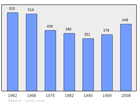
In 2010 the commune had 447 inhabitants. The evolution of the number of inhabitants is known from the population censuses conducted in the commune since 1793. From the 21st century, a census of communes with fewer than 10,000 inhabitants is held every five years, unlike larger communes that have a sample survey every year.[Note 1]
| 1793 | 1800 | 1806 | 1821 | 1831 | 1836 | 1841 | 1846 | 1851 |
|---|---|---|---|---|---|---|---|---|
| 425 | 416 | 450 | 485 | 520 | 540 | 535 | 555 | 547 |
| 1856 | 1861 | 1866 | 1872 | 1876 | 1881 | 1886 | 1891 | 1896 |
|---|---|---|---|---|---|---|---|---|
| 548 | 547 | 513 | 516 | 484 | 459 | 430 | 456 | 471 |
| 1901 | 1906 | 1911 | 1921 | 1926 | 1931 | 1936 | 1946 | 1954 |
|---|---|---|---|---|---|---|---|---|
| 431 | 453 | 427 | 385 | 381 | 392 | 421 | 371 | 438 |
| 1962 | 1968 | 1975 | 1982 | 1990 | 1999 | 2006 | 2010 | - |
|---|---|---|---|---|---|---|---|---|
| 525 | 516 | 406 | 386 | 351 | 378 | - | 447 | - |
Sites and monuments
Barbazan has two sites that are registered as historical monuments:
- Other sites of interest
- The Thermal baths
- The Lake
- The Church of Saint-Michel
Notable people linked to the commune
- Jacques-Marie d'Astorg (1752-1822), Count of Astorg and Roquépine, Baron of Montégut, French soldier in the 18th and 19th centuries.
See also
External links
- Barbazan official website (in French)
- Barbazan Tourism website (in French)
- Barbazan on the Community of Communes of Haut-Comminges website (in French)
- Barbazan on Lion1906
- Barbazan on Géoportail, National Geographic Institute (IGN) website (in French)
- Barbazan on the 1750 Cassini Map
- Barbazan on the INSEE website (in French)
Notes and references
Notes
- At the beginning of the 21st century, the methods of identification have been modified by Law No. 2002-276 of 27 February 2002 Archived 6 March 2016 at the Wayback Machine, the so-called "law of local democracy" and in particular Title V "census operations" allows, after a transitional period running from 2004 to 2008, the annual publication of the legal population of the different French administrative districts. For communes with a population greater than 10,000 inhabitants, a sample survey is conducted annually, the entire territory of these communes is taken into account at the end of the period of five years. The first "legal population" after 1999 under this new law came into force on 1 January 2009 and was based on the census of 2006.
References
- "Populations légales 2017". INSEE. Retrieved 6 January 2020.
- Inhabitants of Haute-Garonne (in French)
- Google Maps
- List of Mayors of France (in French)
- Ministry of Culture, Mérimée PA00094283 Chateau of Bagen (in French)

- Ministry of Culture, Mérimée IA31010024 Flower Garden (in French)
| Wikimedia Commons has media related to Barbazan. |
| Authority control |
|
|---|