Montagne des Érables
The Montagne des Érables, also known as Mont des Érables (translation: Maple Mountain), is a massif located in the Charlevoix-Est regional county municipality in the Charlevoix region of Quebec, Canada. It lies in the Hautes-Gorges-de-la-Rivière-Malbaie National Park and is home to l'Acropole des Draveurs, a popular hike in the province. It is accessible via the entrances to the park, the main one being located in Saint-Aimé-des-Lacs.
| Montagne des Érables | |
|---|---|
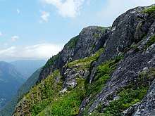
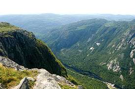 l'Acropole des Draveurs, a face of the mountain, in the foreground | |
| Highest point | |
| Elevation | 1,048 m (3,438 ft) [1] |
| Prominence | 408 m (1,339 ft) [1] |
| Isolation | 5.51 km (18,100 ft) [1] |
| Coordinates | 47°53′22″N 70°27′18″W [2] |
| Naming | |
| English translation | Maple Mountain |
| Language of name | fr |
| Geography | |
 Montagne des Érables | |
| Parent range | Laurentian Mountains |
| Topo map | 21 M/16 |
| Climbing | |
| Easiest route | hiking |
| Access | entrance to the Hautes-Gorges-de-la-Rivière-Malbaie National Park |
Etymology
The mountain (along with many other geographic features and manmade installations in the park), whose name translates to "Maple Mountain," takes its name from the unique presence of maples juxtaposed with the tundra.[3]:21–22
Geography
The massif contains the Acropole des Draveurs (Raftsmen's Acropolis), a rock face of the mountain, at an elevation higher than 800 m (2,600 ft).[4]
Recreation
Hiking
In order to reach the trails to l'Acropole, hikers must take a bus from the reception. The hike is 10 km round trip with an elevation gain of approximately 800 m (2,600 ft). The route is relatively gradual, allowing hikers an unintimidating hike without sudden terrain changes.
References
- "Montagne des Érables". Peakbagger.com. Retrieved 2 Aug 2014.
- Reference number 69174 of the Commission de toponymie du Québec (in French)
- Parc national des Hautes-Gorges-de-la-Rivière-Malbaie : plan directeur (PDF) (in French). Quebec City: Faune et parcs Québec, Direction de la planification des parcs. January 2004. ISBN 2-550-42440-9. Retrieved 2 August 2014.
- Reference number 238838 of the Commission de toponymie du Québec (in French)