Miyun District
Miyun District (simplified Chinese: 密云区; traditional Chinese: 密雲區; pinyin: Mìyún Qū) is situated in northeast Beijing. It has an area of 2,227 square kilometres (860 sq mi) and a population of 460,800 (2010 Census).
Miyun 密云区 | |
|---|---|
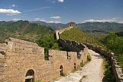 Simatai Great Wall | |
| |
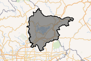
 Location of Miyun District in Beijing | |
| Coordinates: 40°22′28″N 116°50′22″E | |
| Country | People's Republic of China |
| Municipality | Beijing |
| Township-level divisions | 3 subdistricts 17 towns 1 township |
| Area | |
| • Total | 2,227 km2 (860 sq mi) |
| Population (2010) | |
| • Total | 460,800 |
| • Density | 210/km2 (540/sq mi) |
| Time zone | UTC+8 (China Standard) |
| Postal code | 101500 |
| Area code(s) | 0010 |
| Website | bjmy |
History
Miyun was one of the places where Warlord Feng Yuxiang stationed his troops in preparation of the Beijing Coup of 1924.[1] In the 1930s, Miyun District was occupied by the Imperial Japanese Army and became part of the area controlled by the East Hebei Autonomous Council, a puppet state of Japan. The Japanese occupation was challenged, however, when a local Taoist priest managed to incite Miyun's peasantry. As member of the Yellow Sand Society, he garnered followers and convinced them that they could become immune to gunfire through magical rituals that he performed. Thus highly motivated, the peasants launched a rebellion in July 1936 and defeated an East Hopei Army unit that was sent to suppress them.[2] Nearby Imperial Japanese Army forces were consequently mobilized against the insurgents. By September, the uprising was defeated and about 300 of Miyun's Yellow Sand rebels had been killed or wounded in the fighting.[3]
Administrative divisions
.JPG)
.JPG)
There are 3 subdistricts, 17 towns, and 1 township which carry the "area" (地区) label in the district.[4][5] The urban area centers on Gulou Subdistrict, and has an estimated population of 124,500.
| Name | Chinese (S) | Hanyu Pinyin | Population (2010)[6] | Area (km2) |
|---|---|---|---|---|
| Gulou Subdistrict | 鼓楼街道 | Gǔlóu Jiēdào | 104,479 | 1.60 |
| Guoyuan Subdistrict | 果园街道 | Guǒyuán Jiēdào | 52,840 | 7.55 |
| Tanying (Manchu and Mongol Ethnic Township) Area | 檀营(满族蒙古族乡)地区 | Tányíng (Mǎnzú Měnggǔzú Xiāng) Dìqū | 7,571 | 2.73 |
| Miyun town | 密云镇 | Mìyún Zhèn | 18,722 | 24.00 |
| Xiwengzhuang town | 溪翁庄镇 | Xīwēng Zhèn | 19,811 | 87.90 |
| Xitiangezhuang town | 西田各庄镇 | Xītiángèzhuāng Zhèn | 36,056 | 129.60 |
| Shilipu town | 十里堡镇 | Shílǐpù Zhèn | 25,086 | 30.80 |
| Henanzhai town | 河南寨镇 | Hénánzhài Zhèn | 24,067 | 66.70 |
| Jugezhuang town | 巨各庄镇 | Jùgèzhuāng Zhèn | 23,017 | 107.80 |
| Mujiayu town | 穆家峪镇 | Mùjiāyù Zhèn | 33,145 | 102.80 |
| Taishitun town | 太师屯镇 | Tàishītún Zhèn | 27,311 | 202.00 |
| Gaoling town | 高岭镇 | Gāolǐng Zhèn | 14,186 | 111.40 |
| Bulaotun town | 不老屯镇 | Bùlǎotún Zhèn | 15,810 | 193.20 |
| Fengjiayu town | 冯家峪镇 | Féngjiāyù Zhèn | 6,640 | 214.25 |
| Gubeikou town | 古北口镇 | Gǔběikǒu Zhèn | 7,932 | 84.71 |
| Dachengzi town | 大城子镇 | Dàchéngzi Zhèn | 11,648 | 144.00 |
| Dongshaoqu town | 东邵渠镇 | Dōngshàoqú Zhèn | 12,276 | 109.30 |
| Beizhuang town | 北庄镇 | Běizhuāng Zhèn | 7,769 | 83.70 |
| Xinchengzi town | 新城子镇 | Xīnchéngzi Zhèn | 7,993 | 176.50 |
| Shicheng town | 石城镇 | Shíchéng Zhèn | 5,453 | 252.80 |
Geography
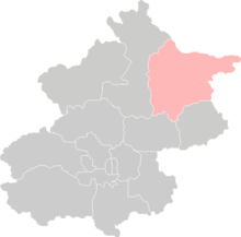
Miyun contains the easternmost point of Beijing Municipality, bordering the Beijing districts of Pinggu to the southeast, Shunyi to the southwest and Huairou to the west as well as Hebei province to the due north and east. The Miyun Reservoir, a major source of water for the city of Beijing, is also located in the county.
Tourism
A popular tourist attraction in Miyun district is Simatai, a section of the Great Wall. Another is Nanshan Ski Resort, one of the largest in the country.[7]
See also
References
- Sheridan (1966), p. 134.
- Morning Tribune Staff (1936), p. 9.
- The China Monthly Review Staff (1936), p. 473.
- These townships are officially classified as subdistricts, but as they coincide with the area of the same name, they are commonly named "areas" (地区)
- 2011年统计用区划代码和城乡划分代码:昂昂溪区 (in Chinese). National Bureau of Statistics of the People's Republic of China. Retrieved 2013-06-28.
- Census Office of the State Council of the People's Republic of China; Population and Employment Statistics Division of the National Bureau of Statistics of the People's Republic of China (2012). 中国2010人口普查分乡、镇、街道资料 (1 ed.). Beijing: China Statistics Print. ISBN 978-7-5037-6660-2.
- "Beijing Nanshan ski village". Archived from the original on 2010-04-12. Retrieved 2010-04-24.
Bibliography
- Sheridan, James E. (1966). Chinese Warlord. The Career of Feng Yü-hsiang. Stanford, California: Stanford University Press.CS1 maint: ref=harv (link)
- Morning Tribune Staff (30 July 1936). "Yellow Sand Cult to be suppressed by Japanese". Morning Tribune. 1 (154). Peiping. p. 9. Retrieved 3 May 2018.CS1 maint: ref=harv (link)
- The China Monthly Review Staff (20 August 1936). ""Yellow Sand" Society Suppressed by Japanese in Demilitarized Zone". The China Monthly Review. 77. Custom House, Shanghai. p. 473.CS1 maint: ref=harv (link)
External links
| Wikivoyage has a travel guide for Miyun. |
![]()
- Official website of Miyun Government (Chinese)
- Illustrated Atlas of Shanhai, Yongping, Jizhou, Miyun, Gubeikou, Huanghua Zhen and Other Areas
| Administration |
|  | ||||||
|---|---|---|---|---|---|---|---|---|
| Economy | ||||||||
| Education | ||||||||
| Transportation |
| |||||||
| Visitor attractions |
| |||||||
| Municipal agencies |
| |||||||
| ||||||||
| Authority control |
|
|---|