Medvezhyi Islands
The Medvezhyi Islands, or Bear Islands (Russian: Медве́жьи острова́; Yakut: Эhэлээх арыылар, Eheleex Arıılar) is an uninhabited group of islands at the western end of the Kolyma Gulf of the East Siberian Sea.
Medvezhyi Islands Эhэлээх арыылар Медве́жьи острова́ | |
|---|---|
Island group | |
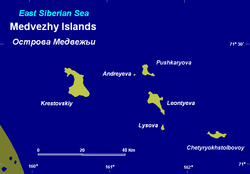 Map of the Medvezhiy Islands. | |
 | |
 Medvezhyi Islands | |
| Coordinates: 70°52′N 161°26′E | |
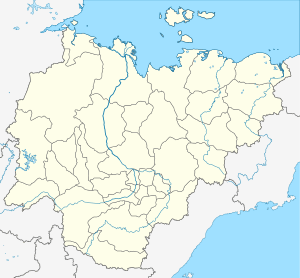
| Country | Russian Federation |
| Federal subject | Far Eastern Federal District |
| Republic | Sakha Republic |
History
The first recorded European to report the existence of the Medvezhyi Islands was Russian explorer Yakov Permyakov in 1710. While sailing from the Lena to the Kolyma River, Permyakov observed the silhouette of the unknown island group in the then little explored East Siberian Sea.
In 1820-1824, during Ferdinand Wrangel's Arctic expedition to the East Siberian Sea and the Chukchi Sea, Arctic explorer Fyodor Matyushkin surveyed and mapped Chetyryokhstolbovoy Island in the Medvezhyi group.
On September 3, 1878, Adolf Erik Nordenskiöld recorded that he sailed close to the island group in the steamship Vega. This report was made during the famous expedition that made the whole length of the Northeast passage for the first time in history.[1]
The group was also explored during the Arctic Ocean Hydrographic Expedition of 1910-1915.[2]
Geography
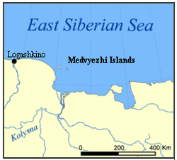
The Medvezhyi Islands are located about 100 kilometres (62 mi) to the north of the mouths of the Kolyma River. They are part of the East Siberian Lowland.[3] The coast of Siberia is about 35 kilometres (22 mi) to the southwest of Krestovsky, the largest island which is about 15 kilometres (9.3 mi) in length.
The sea surrounding the Medvezhyi Islands is covered with fast ice in the winter and the climate is severe. The surrounding sea is obstructed by pack ice even in the summer months. There is commercial fishing in the area of the islands during the summer.[4]
This island group is a part of the territory of the Sakha Republic of Russia. As their name indicates, these islands are a refuge and breeding ground for polar bears.
Islands
There are six islands in the group: Krestovsky, Leontyev, Pushkarev, Lysova, Andreev and Chetyryokhstolbovoy, where there is a polar station which was inaugurated in 1933.[5] The islands are formed of stacked granite, clay and shale. They are mostly covered with tundra vegetation.[6]
Climate
| Climate data for Medvezhyi Islands | |||||||||||||
|---|---|---|---|---|---|---|---|---|---|---|---|---|---|
| Month | Jan | Feb | Mar | Apr | May | Jun | Jul | Aug | Sep | Oct | Nov | Dec | Year |
| Daily mean °C (°F) | −28.7 (−19.7) |
−29.5 (−21.1) |
−26.7 (−16.1) |
−19.6 (−3.3) |
−7.0 (19.4) |
0.4 (32.7) |
2.2 (36.0) |
1.8 (35.2) |
−0.7 (30.7) |
−9.8 (14.4) |
−21.2 (−6.2) |
−26.8 (−16.2) |
−13.8 (7.2) |
| Average precipitation mm (inches) | 9.0 (0.35) |
6.7 (0.26) |
4.5 (0.18) |
5.0 (0.20) |
6.3 (0.25) |
10.0 (0.39) |
20.0 (0.79) |
21.1 (0.83) |
16.1 (0.63) |
14.7 (0.58) |
11.5 (0.45) |
7.4 (0.29) |
132.3 (5.21) |
| Average precipitation days (≥ 1.0 mm) | 3.0 | 1.7 | 1.3 | 1.1 | 1.0 | 2.5 | 4.0 | 5.5 | 5.3 | 5.1 | 3.3 | 1.8 | 35.6 |
| Mean monthly sunshine hours | 0 | 48 | 205 | 292 | 233 | 245 | 230 | 126 | 57 | 39 | 5 | 0 | 1,480 |
| Source: NOAA[7] | |||||||||||||
Features of the islands
 Chetyrokhstolbovoy Island (70°37‘50‘‘N, 162°22’30’’E)
 Kigilyakh stone pillars on Chetyrokhstolbovoy Island. Kigilyakh means "stone man" in Yakut.
 Kigilyakhs on Chetyrokhstolbovoy Island
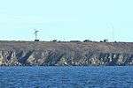 Chetyrokhstolbovoy Island (Polar Station)
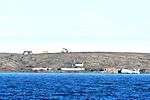 Chetyrokhstolbovoy Island
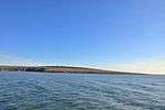
 Krestovsky Island
(70°48’N, 160°40’E)
See also
References
- Albert Hastings Markham. Arctic Exploration, 1895
- The Arctic Ocean Hydrographic Expedition 1910-1915 Archived October 16, 2010, at the Wayback Machine
- Oleg Leonidovič Kryžanovskij, A Checklist of the Ground-beetles of Russia and Adjacent Lands. p. 16
- Commercial fishing Archived 2011-06-29 at the Wayback Machine
- История полярных арктических станций с 30-х годов XX века
- Geography Archived September 27, 2007, at the Wayback Machine
- "Cetyrehstolbovoj IL Climate Normals 1961–1990". National Oceanic and Atmospheric Administration. Retrieved 27 February 2016.
|