Matsulu
Matsulu is a township in the Mbombela Municipality under the Ehlanzeni District Municipality in the Mpumalanga province of South Africa. It lies next to the N4 national road 41 km east of Nelspruit(Mbombela) CBD, 3 km before the Kaapmuiden train station.
Matsulu | |
|---|---|
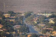
 (Top:) View of Matsulu C, (bottom:) Spoornet Train Bridge, Matsulu Shopping Complex | |
 Matsulu  Matsulu | |
| Coordinates: 25.515°S 31.340°E | |
| Country | South Africa |
| Province | Mpumalanga |
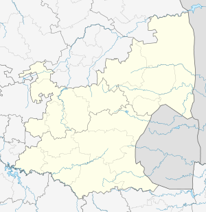
| District | Ehlanzeni |
| Municipality | Mbombela |
| Established | 1970s (unclear) |
| Government | |
| • Type | Representative |
| • Councillor | (African National Congress) |
| Area | |
| • Total | 17.98 km2 (6.94 sq mi) |
| Population (2011)[1] | |
| • Total | 47,306 |
| • Density | 2,600/km2 (6,800/sq mi) |
| Racial makeup (2011) | |
| • Black African | 99.5% |
| • Coloured | 0.2% |
| • Indian/Asian | 0.1% |
| • White | 0.1% |
| • Other | 0.1% |
| First languages (2011) | |
| • Swazi | 92.8% |
| • Tsonga | 2.5% |
| • English | 1.8% |
| • Zulu | 1.1% |
| • Other | 1.9% |
| Time zone | UTC+2 (SAST) |
| Postal code (street) | 1203 |
| PO box | 1203 |
| Area code | 013 |
The township is divided into three (3) sections, namely;
- Matsulu A
- Matsulu B
- Matsulu C
History
The township was established in the 1970s. Its existence came to be when African natives were forcefully removed from the nearby lands to form sugarcane plantations then relocated to the land which now forms Matsulu Township. It is alleged that the area was named after a resident who had informally settled there prior to the forced allocation, the name of the resident was Matsulu.
From the 1970s to 1994 the township was administrated by the now defunct KaNgwane District Bantustan. It played a major role as an official residency for Members of Parliament (KaNgwane District Bantustan).
Like many South African townships, Matsulu was embroiled in Apartheid-era violence during the 80s and the early 90s. In 1994 the administration of the township was handed over to the then Greater Nelspruit City Council ending the KaNgwane District Bantustan administration. This was due to the termination of Apartheid and its policies.
Post 1994
Matsulu was re-organised and municipal wards were allocated to streamline it with the rest of the City Council (now called Mbombela Municipality).
Economy
The township's economy is heavily dependent on its mother city Nelspruit (Mbombela) where most of its employed skilled and semiskilled residents work. The township's economy itself is largely informal where a few hundred find employment in primary economy sectors like brick manufacturing, bricklaying, while some people are also employed on the nearby fruit farms as seasonal workers.
Cornershops known as spaza shops are found scattered throughout the area which are often owned and operated by foreigners like Somali, Ethiopian and Pakistani immigrants on leased residential sites.
There is a single formal shopping complex with a dozen shops encored by the Spar retailer. However, there is no dedicated CBD, nor industrial site, so many businesses operate unregulated at random locations without any municipal control or any observation of the country's labour laws.
Educational Institutions
Here is the list of public education institutions in Matsulu:
Primary Schools
- Benjamin Primary School
- Enzani Primary School
- Funindlela Primary School
- Lethakuthula Primary School
- Matsulu Primary School
- Phumalanga Primary School
- Sehlulile Primary School
- Sukumani Primary School
- Takheleni Primary School
- Tsandzanani Primary School
High Schools
- Tikhontele Secondary School
- Sibusisiwe Secondary School
- Masitakhe Secondary School
- Sitfokotile Secondary School
Tertiary
- Matsulu TVET Skills Academy
Transportation
Ways to get in-and-around Matsulu while using public transportation. They include;
- Minibus taxis which operate on a short range distance from Matsulu to Nelspruit(Mbombela), Malelane and back.
- Buscor buses which operate on a short range distance from Matsulu to Nelspruit(Mbombela), Malelane, Barberton and back.
- Local taxis which only operate in and around Matsulu serving the three (3) sections of the township. These local taxis take form of Toyota Avanzas and they transport locals on tarred/paved roads, ignoring the gravel.
- Via air utilising the Kruger Mpumalanga International Airport with flights from major cities in Southern Africa, Matsulu is 40 km east of the airport.
- Railway utilising the Kaapmuiden train station which is 3 km outside Matsulu. It should be of note that the train arrives only once a day at around 18h00 local time coming from Johannesburg.
Climate
Matsulu has a subtropical climate with very warm humid summers and cool dry winters.
Nearby Places of Interest
Tourist attractions within the 150 km radius :
References
- "Main Place Matsulu". Census 2011.
Municipalities and communities of Ehlanzeni District Municipality, Mpumalanga | ||
|---|---|---|
District seat: Mbombela | ||
| Mbombela | .svg.png) Ehlanzeni District within South Africa | |
| Nkomazi | ||
| Thaba Chweu | ||
| Umjindi | ||
| Bushbuckridge | ||