Matari Airport
Matari Airport (IATA: IRP, ICAO: FZJH) is an airport serving Isiro, a city in the Orientale Province of the Democratic Republic of the Congo. The airport is 6 kilometres (3.7 mi) northwest of the city.
Matari Airport | |||||||||||
|---|---|---|---|---|---|---|---|---|---|---|---|
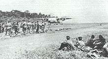 Matari Airport (then Paulis Airport) during Operation Dragon Noir, 1964 | |||||||||||
| Summary | |||||||||||
| Airport type | Civil | ||||||||||
| Operator | Government | ||||||||||
| Serves | Isiro | ||||||||||
| Location | Democratic Republic of the Congo | ||||||||||
| Elevation AMSL | 2,438 ft / 743 m | ||||||||||
| Coordinates | 2°49′40″N 27°35′15″E | ||||||||||
| Map | |||||||||||
 IRP Location of Matari Airport in DRC | |||||||||||
| Runways | |||||||||||
| |||||||||||
The Isiro-Matari VOR/DME (Ident: IRO) is located 1.1 nautical miles (2.0 km) southeast of the airport.[4]
Airlines and destinations
| Airlines | Destinations |
|---|---|
| Compagnie Africaine d'Aviation[5] | Beni, Bukavu, Bunia, Goma, Kalemie, Kisangani, Lubumbashi |
Accidents and incidents
On 5 September 2005, a Kavatshi Airlines Antonov An-26B struck a tree and crashed 1.5 kilometres (1 mi) from Runway 31 at Matari Airport while on final approach in fog, killing all 11 people on board.[6]
See also

- Transport in the Democratic Republic of the Congo
- List of airports in the Democratic Republic of the Congo
References
- Airport information for Matari Airport at Great Circle Mapper.
- Airport information for Matari Airport at World Aero Data. Data current as of October 2006.
- "Matari Airport". Google Maps. Google. Retrieved 29 April 2018.
- "SkyVector: Flight Planning / Aeronautical Charts". skyvector.com. Retrieved 2018-08-20.
- Compagnie Africaine d'Aviation timetable (August 2013)
- "accident record". aviation-safety.net. Retrieved 25 January 2015.
External links
- SkyVector - Isiro-Matari Airport
- Accident history for Matari Airport at Aviation Safety Network
- OpenStreetMap - Matari
This article is issued from Wikipedia. The text is licensed under Creative Commons - Attribution - Sharealike. Additional terms may apply for the media files.