Orientale Province
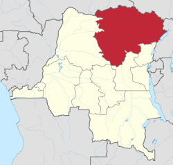
Orientale (French: Province orientale) (also Oriental; formerly Haut-Zaïre, then Haut-Congo) is one of the eleven former provinces of the Democratic Republic of the Congo. The province lay in the northeast of the country. It bordered Équateur to the west, Kasaï-Oriental province to the southwest, Maniema to the south, and North Kivu to the southeast. It also bordered the Central African Republic and South Sudan to the north, and Uganda to the east. The provincial capital is Kisangani.
Orientale Province Province Orientale | |
|---|---|
 | |
| Country | |
| Capital | Kisangani |
| Area | |
| • Total | 503,239 km2 (194,302 sq mi) |
| Population (2010 est.) | |
| • Total | 8,197,975 |
| • Density | 16/km2 (42/sq mi) |
| Official language | French |
| National language | Swahili, Lingala |
The province was divided into the Bas-Uélé, Haut-Uélé and Tshopo districts and the Ituri Interim Administration. These became were elevated to provinces in 2015 under the 2006 constitution.
History
Orientale Province was formed in 1966 from the amalgamation of the regions of Uele, Kibali-Ituri and Haut-Congo. In 2015, the province dissolved into the provinces of Bas-Uélé, Haut-Uélé, Ituri and Tshopo.
In 1998 the Orientale villages of Durba and Watsa were the center of an outbreak of Marburg virus disease among gold mine workers.
The Ituri district of Orientale was the scene of the Ituri conflict.
As of 2014, militia groups continue to fight in the province and have reportedly committed many atrocities against the local population, such as forcing women into sex slavery and forcing men to work in mines.[1]
Approximate correspondence between historical and current province
| Belgian Congo | Republic of the Congo | Zaire | Democratic Republic of the Congo | ||||||
|---|---|---|---|---|---|---|---|---|---|
| 1908 | 1919 | 1932 | 1947 | 1963 | 1966 | 1971 | 1988 | 1997 | 2015 |
| 22 districts | 4 provinces | 6 provinces | 6 provinces | 21 provinces + capital | 8 provinces + capital | 8 provinces + capital | 11 provinces | 11 provinces | 26 provinces |
| Bas-Uele | Orientale | Stanleyville | Orientale | Uele | Orientale | Haut-Zaïre | Orientale | Bas-Uele | |
| Haut-Uele | Haut-Uele | ||||||||
| Ituri | Kibali-Ituri | Ituri | |||||||
| Stanleyville | Haut-Congo | Tshopo | |||||||
| Aruwimi | |||||||||
| Maniema | Costermansville | Kivu | Maniema | Kivu | Maniema | ||||
| Lowa | |||||||||
| Kivu | Nord-Kivu | Nord-Kivu | |||||||
| Kivu-Central | Sud-Kivu | ||||||||
Current divisions
References
- Sexual slavery rife in the Democratic Republic of the Congo
- "Haut-Congo: largest cities and towns and statistics of their population". World Gazetteer. Archived from the original on 2013-02-10.
Bibliography
- Gwillim Law (1999). "Democratic Republic of the Congo". Administrative Subdivisions of Countries: A Comprehensive World Reference, 1900 through 1998. US: McFarland & Company. pp. 92–94. ISBN 0786407298.
External links
- Site of the province (Gouverneur and province assembly), in French
- Bamanisajean.unblog.fr is Governor Jean Bamanisa's blog site.
- Stanleyville.be City of Kisangani Website.
- @Prov_orientale Twitter for Orentale Provincial Government
- Facebook Orentale Provincial Government
- CDC "Map of the Democratic Republic of the Congo indicating the neighboring villages of Durba and Watsa, the epicenter of the 1998 outbreak of Marburg hemorrhagic fever."
- "Liste des gouverneurs de la Province Orientale". Stanleyville.be (in French). Jean-Luc Ernst. (1913-1960); +1960-2015