Masindi
Masindi is a town in the Western Region of Uganda. It is on the road between Kampala and the Murchison Falls National Park. It is the site of the headquarters of the Masindi District.[2]
Masindi | |
|---|---|
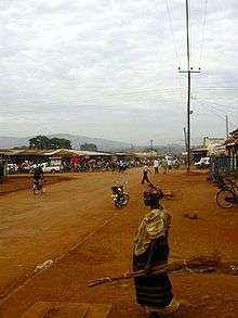 Market Street Masindi on a Sunday morning | |
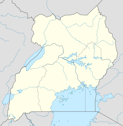 Masindi Location in Uganda | |
| Coordinates: 01°41′01″N 31°43′20″E | |
| Country | |
| Region | Western Region of Uganda |
| Sub-region | Bunyoro sub-region |
| District | Masindi District |
| Elevation | 4,026 ft (1,227 m) |
| Population (2014 Census) | |
| • Total | 94,622[1] |
Location
Masindi is approximately 211 kilometres (131 mi) northwest of Kampala, Uganda's capital and largest city, on an all-weather tarmac highway.[3] This location is approximately 57 kilometres (35 mi), by road, north-east of Hoima, the largest city in the Bunyoro sub-region.[4] The coordinates of Masindi are 1°41'01.0"N, 31°43'20.0"E (Latitude:1.683611; Longitude:31.722222).[5] Masindi Town lies at an average elevation of 1,227 metres (4,026 ft) above sea level.[6]
Population
According to the 2002 national census, the population of Masindi was about 28,300. In 2010, the Uganda Bureau of Statistics (UBOS) estimated the population at 43,000. In 2011, UBOS estimated the mid-year population at 45,400.[7] The national population census conducted in August 2014 put the population at 94,622.[1]
History
As capital of Bunyoro, Masindi was visited by Samuel and Florence Baker, British explorers and anti-slavery campaigners, from 25 April 1872 to 14 June 1873. The Baker expedition was forced to withdraw because of the hostility of the Omukama Kabaléga, the King of Bunyoro at the time. The White Fathers founded here a mission in the 1910s.[8] The town was developed as a commercial centre due to trade in cotton during the second half of the 19th century.[2]
Points of interest
These additional points of interest are within the town limits or close to the edges of town:[2] (a) offices of Masindi Town Council (b) Masindi Hospital, a 200-bed public hospital administered by the Uganda Ministry of Health (c) Masindi Hotel, one of the oldest hotels in the country, built in 1923 (d) a branch of the National Social Security Fund (e) the main campus of the Kigumba Petroleum Institute, 44 kilometres (27 mi) northeast of Masindi (f) Kinyara Sugar Works, one of the three major manufacturers of refined sugar in Uganda, located 15 kilometres (9 mi) west of Masindi (g) Masindi Airport, a public airport, administered by the Civil Aviation Authority of Uganda.[9]
Challenges
A profile of the town written by the New Vision newspaper identified three major challenges. The first challenge was the inadequacy of income-generating projects outside of the town centre. Three out of four divisions in town; Kigulya, Karujubu and Nyagahya are unable to generate enough revenue to meet service demands.[2] The second major challenge is the inadequacy of sanitation services. The town had five public toilets, as of November 2013, and all of them were located in the town's Central division. Masindi is serviced by National Water and Sewerage Corporation, but the services are concentrated in the town centre.[2] The third major challenge for the town of Masindi is that of garbage disposal. The town lacked adequate funding to hire staff and purchase fuel to dispose of the town's garbage. However, the Central government had provided equipment to carry out the task.[2]
References
- UBOS (27 August 2014). "The Population of The Regions of the Republic of Uganda And All Cities And Towns of More Than 15,000 Inhabitants". Citypopulation.de Quoting Uganda Bureau of Statistics (UBOS). Retrieved 23 February 2015.
- Geoffrey Araali Mutegeki (5 October 2013). "Toilet Use In Buvuma Remains A Luxury - Study". New Vision. Kampala. Retrieved 22 June 2019.
- Globefeed.com (22 June 2019). "Distance between Kampala, Uganda and Masindi, Uganda". Globefeed.com. Retrieved 22 June 2019.
- Globefeed.com (22 June 2019). "Distance between Hoima, Uganda and Masindi, Uganda". Globefeed.com. Retrieved 22 June 2019.
- Google (2 July 2015). "Location of Masindi Town" (Map). Google Maps. Google. Retrieved 2 July 2015.
- Floodmap (2019). "Elevation of Masindi Town". Floodmap.net. Retrieved 22 June 2019.
- UBOS. "Estimated Population of Masindi In 2002, 2010 & 2011" (PDF). Uganda Bureau of Statistics (UBOS). Archived from the original (PDF) on 7 July 2014. Retrieved 8 May 2014.
- To The Heart Of The Nile: Lady Florence Baker and the Exploration of Central Africa, by Pat Shipman
- Uganda Civil Aviation Authority (2019). "About Masindi Airfield". Entebbe: Civil Aviation Authority of Uganda. Retrieved 22 June 2019.
External links
| Wikimedia Commons has media related to Masindi. |
| Wikivoyage has a travel guide for Masindi. |
Capital: Masindi | ||
| Towns and villages |  | |
| Geography | ||
| Economy |
| |
| Energy |
| |
| Notable landmarks |
| |
| Health | ||
| Transport | ||
| Notable people | ||