Masina, Purulia
Masina is a village in the Jhalda I CD block in the Jhalda subdivision of the Purulia district in the state of West Bengal, India.
Masina | |
|---|---|
Village | |
 Masina Location in West Bengal, India  Masina Masina (India) | |
| Coordinates: 23°21′30.6″N 85°57′11.9″E | |
| Country | |
| State | West Bengal |
| District | Purulia |
| Population (2011) | |
| • Total | 2,724 |
| Languages | |
| • Official | Bengali, English |
| Time zone | UTC+5:30 (IST) |
| Telephone/STD code | 03254 |
| Lok Sabha constituency | Purulia |
| Vidhan Sabha constituency | Baghmundi |
| Website | purulia |
Geography
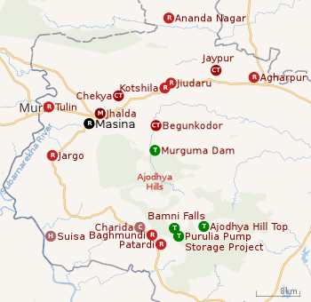 |
| Places in Jhalda subdivision in Purulia district M: municipality, CT: census town, R: rural/ urban centre, H: historical/ religious centre, C: craft centre, T: tourist cetre Owing to space constraints in the small map, the actual locations in a larger map may vary slightly |
Location
Masina is located at 23°21′30.6″N 85°57′11.9″E.
Area overview
Purulia district forms the lowest step of the Chota Nagpur Plateau. The general scenario is undulating land with scattered hills. Jhalda subdivision, shown in the map alongside, is located in the western part of the district, bordering Jharkhand. The Subarnarekha flows along a short stretch of its western border. It is an overwhelmingly rural subdivision with 91.02% of the population living in the rural areas and 8.98% living in the urban areas. There are 3 census towns in the subdivision. The map alongside shows some of the tourist attractions in the Ajodhya Hills. The area is home to Purulia Chhau dance with spectacular masks made at Charida. The remnants of old temples and deities are found in the subdivision also, as in other parts of the district.[1][2][3][4][5][6]
Note: The map alongside presents some of the notable locations in the subdivision. All places marked in the map are linked in the larger full screen map.
Demographics
According to the 2011 Census of India, Masina had a total population of 2,724 of which 1,395 (51%) were males and 1,329 (49%) were females. There were 353 persons in the age range of 0 to 6 years. The total number of literate people in Masina was 1,447 (61.03% of the population over 6 years).[7]
CD block HQ
The headquarters of the Jhalda I CD block are located at Masina.[8]
Transport
A short stretch of local roads link Masina to State Highway 4.[9]
Jhalda railway station, on the Gomoh Muri line, is located nearby.[9]
Healthcare
Jhalda Rural Hospital, with 30 beds, is the major government medical facility in Jhalda I CD block.[10]
References
- Houlton, Sir John, Bihar, the Heart of India, 1949, p. 170, Orient Longmans Ltd.
- "District Statistical Handbook 2014 Purulia". Tables 2.1, 2.2. Department of Planning and Statistics, Government of West Bengal. Archived from the original on 21 January 2019. Retrieved 12 January 2020.
- "Purulia". Department of Tourism. Government of West Bengal. Retrieved 1 February 2020.
- "Chhau dance of Purulia". Itsavpedia. Retrieved 1 February 2020.
- "District Census Handbook: Puruliya – Series 20, Part Xii A, Census of India 2011" (PDF). Page 102: Brief Description of Places of Religious, Historical or Archaeological Importance and Places of Tourist Interest of the District. Directorate of Census Operations, West Bengal. Retrieved 28 January 2020.
- "Deuli, Harup and Suisa, Crumbling Temples, Scattered Statues and Single Room Museum". Rangan Dutta/ Wordpress. Retrieved 21 January 2020.
- "2011 Census – Primary Census Abstract Data Tables". West Bengal – District-wise. Registrar General and Census Commissioner, India. Retrieved 2 December 2016.
- "District Census Handbook: Puruliya" (PDF). Map of District Puruliya with CD Block HQs and Police Stations (on the fifth page). Directorate of Census Operations, West Bengal, 2011. Retrieved 2 December 2016.
- Google maps
- "Health & Family Welfare Department" (PDF). Health Statistics – Rural Hospitals. Government of West Bengal. Retrieved 21 January 2020.
Cities, towns and locations in Purulia district, West Bengal | |||||||||
|---|---|---|---|---|---|---|---|---|---|
| Cities, municipal and census towns |
| ||||||||
| Locations other than cities and towns |
| ||||||||
| Related topics |
| ||||||||