Jhalda subdivision
Jhalda subdivision is a subdivision of the Purulia district in the state of West Bengal, India.
Jhalda subdivision | |
|---|---|
Subdivision | |
 Jhalda subdivision Location in West Bengal, India  Jhalda subdivision Jhalda subdivision (India) | |
| Coordinates: 23.37°N 85.97°E | |
| Country | |
| State | West Bengal |
| District | Purulia |
| Headquarters | Jhalda |
| Area | |
| • Total | 1,233.97 km2 (476.44 sq mi) |
| Population (2011) | |
| • Total | 573,771 |
| • Density | 460/km2 (1,200/sq mi) |
| Languages | |
| • Official | Bengali, English |
| Time zone | UTC+5:30 (IST) |
| ISO 3166 code | IN-WB |
| Vehicle registration | WB |
| Website | http://purulia.gov.in/ |
History
Purulia district was divided into four subdivisions, viz., Purulia Sadar, Manbazar, Jhalda and Raghunathpur, with effect from 6 April 2017, as per Order No. 100-AR/P/2R-2/1999 dated 30 March 2017 issued by the Government of West Bengal, in the Kolkata Gazette dated 30 March 2017.[1]
Subdivisions
Purulia district is divided into the following administrative subdivisions:[2][3][4]
| Subdivision | Headquarter | Area km2 | Population (2011) | Rural Population % (2011) | Urban Population % (2011) |
|---|---|---|---|---|---|
| Purulia Sadar | Purulia | 1,474.81 | 878,373 | 81.42 | 18.58 |
| Manbazar | Manbazar | 1,766.55 | 640,588 | 96.32 | 3.68 |
| Jhalda | Jhalda | 1,233.97 | 573,771 | 91.02 | 8.98 |
| Raghunathpur | Raghunathpur | 1,733.01 | 838,128 | 83.80 | 16.20 |
| Purulia district | Purulia | 6208.34 | 2,930,860 | 87.24 | 12.76 |
Note: The 2011 census data has been recast as per reorganisation of the subdivisions. There may be minor variations.
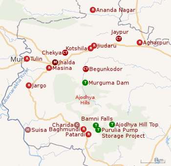 |
| Places in Jhalda subdivision in Purulia district M: municipality, CT: census town, R: rural/ urban centre, H: historical/ religious centre, C: craft centre, T: tourist cetre Owing to space constraints in the small map, the actual locations in a larger map may vary slightly |
Police stations
Police stations in the Jhalda subdivision have the following features and jurisdiction: [2][3][5]
| Police Station | Area covered km2 | Inter-state border km | Municipal Town | CD block |
|---|---|---|---|---|
| Baghmundi | 275 | 41.91 | - | Banghmundi |
| Jaypur | 230.50 | 52 | - | Joypur |
| Jhalda | 290 | 48.7 | Jhalda | Jhalda I, Jhalda II (part) |
| Kotshila | 284 | 25.48 | - | Jhalda II (part) |
Blocks
Community development blocks in Jhalda subdivision are: [2][3][4]
| CD block | Headquarters | Area km2 | Population (2011) | SC % | ST % | Literacy Rate % | Census Towns |
|---|---|---|---|---|---|---|---|
| Baghmundi | Patardi | 427.95 | 135,579 | 10.36 | 25.11 | 57.17 | |
| Jhalda I | Masina | 315.09 | 137,143 | 12.39 | 11.38 | 66.18 | |
| Jhalda II | Kotshila | 256.61 | 148,156 | 10.57 | 10.74 | 54.76 | 2 |
| Joypur | Jaypur | 230.47 | 133,349 | 14.37 | 9.80 | 57.94 | 1 |
Gram panchayats
Gram panchayats in Jhalda subdivision are : [2][6]
- Bagmundi block: Ajodhya, Beergram, Matha, Sindri, Baghmundi, Burda–Kalimati, Serengdih and Tunturi–Suisa.
- Jhalda–I block: Ichag, Jhalda–Darda, Mathari–Khamar, Tulin, Ilu–Jargo, Kalma, Noyadih, Hensahatu, Marum Osina and Pusti.
- Jhalda–II block: Bamniya–Belyadih, Chitmu, Nowahatu, Begunkodar, Hirapur Adardih, Rigid, Chekya, Majhidih and Tatuara.
- Joypur block: Baragram, Joypur, Ropo, Upankahan, Ghagra, Mukundapur and Sidhi–Jamra.
Education
Given in the table below (data in numbers) is a comprehensive picture of the education scenario in Purulia district, after reorganisation of the district in 2017, with data for the year 2013-14. (There may be minor variations because of data recasting).: [2][3]
| Subdivision | Primary School |
Middle School |
High School |
Higher Secondary School |
General College, Univ |
Technical / Professional Instt |
Non-formal Education | |||||||
|---|---|---|---|---|---|---|---|---|---|---|---|---|---|---|
| Institution | Student | Institution | Student | Institution | Student | Institution | Student | Institution | Student | Institution | Student | Institution | Student | |
| Purulia Sadar | 818 | 87,425 | 114 | 7,292 | 26 | 11,345 | 83 | 80,138 | 6 | 12,463 | 11 | 1,806 | 1,461 | 49,234 |
| Manbazar | 832 | 59,105 | 121 | 4,141 | 21 | 7,615 | 64 | 63,466 | 5 | 5,441 | 3 | 256 | 1,371 | 41,267 |
| Jhalda | 533 | 53,629 | 67 | 3,453 | 2 | 1,415 | 47 | 55,492 | 6 | 2,332 | 2 | 98 | 836 | 34,779 |
| Raghunathpur | 818 | 72,073 | 126 | 8,925 | 31 | 16,055 | 67 | 68,188 | 4 | 7,007 | 5 | 649 | 1,761 | 45,472 |
| Purulia district | 3,001 | 272,232 | 428 | 23,811 | 80 | 36,430 | 261 | 267,284 | 21 | 27,243 | 21 | 3.009 | 5,429 | 170,752 |
Note: Primary schools include junior basic schools; middle schools, high schools and higher secondary schools include madrasahs; technical schools include junior technical schools, junior government polytechnics, industrial technical institutes, industrial training centres, nursing training institutes etc.; technical and professional colleges include engineering colleges, medical colleges, para-medical institutes, management colleges, teachers training and nursing training colleges, law colleges, art colleges, music colleges etc. Special and non-formal education centres include sishu siksha kendras, madhyamik siksha kendras, centres of Rabindra mukta vidyalaya, recognised Sanskrit tols, institutions for the blind and other handicapped persons, Anganwadi centres, reformatory schools etc.[3]
Educational institutions
The following institutions are located in Jhalda subdivision:
- Ramkrishna Mahato Government Engineering College (earlier known as Purulia Government Engineering College) was established at Agharpur in 2016.[7]
- Ananda Marga College was established in 1966 at Annanda Nagar, Pundag.[8]
- Achhruram Memorial College was established in 1975 at Jhalda.[9]
- Netaji Subhas Ashram Mahavidyalaya was established in 1985 at Suisa.[10]
- Bikramjeet Goswami Memorial College was established at Jaypur in 2009.[11]
- Chitta Mahato Memorial College was established 2010 at Jargo.[12]
- Kotshila Mahavidyalaya was established in 2010 at Jiudaru.[13]
Healthcare
The table below (all data in numbers) presents an overview of the medical facilities available and patients treated in the hospitals, health centres and sub-centres in 2014 in Purulia district, after reorganisation of the district in 2017, with data for the year 2013-14. (There may be minor variations because of data recasting).: [2][3]
| Subdivision | Health & Family Welfare Deptt, WB | Other State Govt Deptts |
Local bodies |
Central Govt Deptts / PSUs |
NGO / Private Nursing Homes |
Total | Total Number of Beds |
Total Number of Doctors* |
Indoor Patients |
Outdoor Patients | |||
|---|---|---|---|---|---|---|---|---|---|---|---|---|---|
| Hospitals |
Rural Hospitals |
Block Primary Health Centres |
Primary Health Centres | ||||||||||
| Purulia Sadar | 2 | 2 | 3 | 13 | 2 | - | - | 9 | 31 | 1,203 | 96 | 209,390 | 1,626,712 |
| Manbazar | - | 1 | 4 | 14 | - | - | - | - | 19 | 254 | 40 | 35,184 | 990,561 |
| Jhalda | - | 1 | 3 | 10 | - | - | - | - | 15 | 196 | 23 | 28,522 | 820,961 |
| Raghunathpur | 1 | 1 | 4 | 13 | - | - | 1 | 2 | 22 | 835 | 77 | 55,866 | 1,071,786 |
| Purulia district | 3 | 5 | 14 | 50 | 2 | - | 1 | 12 | 87 | 2,488 | 236 | 328,962 | 4,510,020 |
.* Excluding nursing homes.
Medical facilities
Medical facilities in Jhalda subdivision are as follows:
Rural Hospitals: (Name, CD block, location, beds) [14]
- Jhalda Rural Hospital, Jhalda I CD block, Jhalda, 30 beds
- Muralhar Kotshila Rural Hospital, Jhalda II block, Jindaru, 30 beds
- Jaypur Rural Hospital, Joypur CD block, Jaypur 30 beds
- Pathardihi Rural Hospital, Baghmundi CD block, Pathardihi, 30 beds
Primary Health Centres : (CD block-wise)(CD block, PHC location, beds)[15]
- Baghmundi CD block: Korang (6), Tunturi (10), Ajodhya Hill (PO Ajodhya) (12)
- Joypur CD block: Baragram (4), Sidhi (4), Darikuri (10)
- Jhalda I CD block: Ilu (10), Mahatomara (6)
- Jhalda II CD block: Begunkodor (10), Khatanga (4)
Electoral constituencies
Lok Sabha (parliamentary) and Vidhan Sabha (state assembly) constituencies in Purulia district were as follows:
| Lok Sabha constituency | Vidhan Sabha constituency | Reservation | CD Block and/or Gram panchayat |
|---|---|---|---|
| Purulia | Balarampur | None | Balarampur CD Block; Chakaltore, Dimdiha, Durku, Garafusra, Lagda and Sonaijuri gram panchayats of Purulia I CD Block; and Chatu Hansa, Hensla and Puara gram panchayats of Arsha CD Block.[16] |
| Baghmundi | None | Jhalda municipality; Jhalda I and Baghmundi CD Blocks; Hetgugui and Sirkabad gram panchayats of Arsha CD Block.[16] | |
| Joypur | None | Joypur and Jhalda II CD Blocks; Arsha, Beldih and Manikary gram panchayats of Arsha CD Block.[16] | |
| Purulia | None | Purulia municipality; Purulia II CD Block; Bhandar Purachipida and Manara gram panchayats of Purulia I CD Block.[16] | |
| Manbazar | ST | Manbazar I and Puncha CD Blocks; Chatumadar, Daldali and Manguria Lalpur gram panchayats of Hura CD Block.[16] | |
| Kashipur | None | Kashipur CD Block; Hura, Jabarrah, Kalabani, Keshargarh, Ladhurka, Lakhanpur and Rakhera Bishpuri gram panchayats of Hura CD Block.[16] | |
| Para | SC | Para and Raghunathpur II CD Blocks.[16] | |
| Bankura | Raghunathpur | SC | Raghunathpur municipality; Raghunathpur I, Neturia and Santuri CD Blocks.[16] |
| Other assembly segments in Bankura district | |||
| Jhargram (ST) | Bandwan | ST | Bandwan, Barabazar and Manbazar II CD Blocks.[16] |
| Other assembly segments in Paschim Medinipur district | |||
References
- "The Kolkata Gazette, 30 March 2017" (PDF). Government of West Bengal. Retrieved 17 January 2020.
- "Purulia – the official website of Purlia district". Administration. District administration. Retrieved 16 January 2020.
- "District Statistical Handbook 2014 Purulia". Tables 2.1, 2.2. Department of Planning and Statistics, Government of West Bengal. Retrieved 16 January 2020.
- "CD block Wise Primary Census Abstract Data(PCA)". 2011 census: West Bengal – District-wise CD blocks. Registrar General and Census Commissioner, India. Retrieved 16 January 2020.
- "Purulia District Police". PDC. Retrieved 16 January 2020.
- "Directory of District, Subdivision, Panchayat Samiti/ Block and Gram Panchayats in West Bengal". Purulia - Revised in March 2008. Panchayats and Rural Development Department, Government of West Bengal. Retrieved 16 January 2020.
- "Ramkrishna Mahato Government Engineering College". RKMGEC. Retrieved 6 February 2020.
- "Ananda Marga College". Ananda Nagar. Retrieved 17 January 2020.
- "Achhruram Memorial College". AMC. Retrieved 17 January 2020.
- "Netaji Subhas Ashram Mahavidyalaya". NSAM. Retrieved 17 January 2020.
- "Bikramjeet Goswami Memorial College". BGMC. Retrieved 17 January 2020.
- "Chitta Mahato Memorial College". CMMC. Retrieved 17 January 2020.
- "Kashipur Mahavidyalaya". KM. Retrieved 17 January 2020.
- "Health & Family Welfare Department" (PDF). Health Statistics – Rural Hospitals. Government of West Bengal. Retrieved 18 January 2020.
- "Health & Family Welfare Department" (PDF). Health Statistics – Primary Health Centres. Government of West Bengal. Retrieved 18 January 2020.
- "Delimitation Commission Order No. 18 dated 15 February 2006" (PDF). West Bengal. Election Commission of India. Retrieved 10 October 2016.