Marshepaug River
The Marshepaug River is a 3-mile-long (4.8 km) stream in the towns of Goshen and Litchfield in northwest Connecticut in the United States. The river rises near the southwest corner of Woodbridge Lake and then flows in a southwest direction through the Milton Center Historic District to its mouth on the East Branch of the Shepaug River.[3] It drains an area of more than 7,000 acres (2,800 ha) and has a gradient of over 52 feet per mile.[3]
| Marshepaug River (Also called Ackerman Brook, Great Pond River, Marshapogge River, Mashepaug River,
and other names) [1] | |
|---|---|
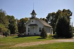 Milton Historic District on the Marshepaug River
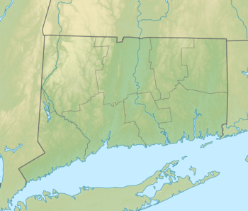 Source Mouth Source and mouth of Marshepaug River in Connecticut | |
| Location | |
| Country | United States |
| States | Connecticut |
| Towns | Goshen, Litchfield |
| Physical characteristics | |
| Source | Woodbridge Lake |
| • location | Goshen, Massachusetts |
| • coordinates | (41°47′53″N 73°15′13″W) |
| • elevation | 1,138 ft (347 m) [2] |
| Mouth | East Branch of the Shepaug River |
• location | Litchfield, Connecticut |
• coordinates | (41°46′01″N 73°16′39″W) |
• elevation | 978 ft (298 m) [1] |
| Length | 3 mi (4.8 km)[3] |
| Basin size | 7,291.86 acres (2,950.91 ha) [4] |
| Width | |
| • maximum | 30 feet (9.1 m)[3] |
| Basin features | |
| River system | Housatonic |
| Gradient | 52.66 fpm |
History
During the 19th century, the river provided waterpower for sawmills, gristmills, bloomery forges, and other industries.[5]
References
- "Marshepaug River". Geographic Names Information System. United States Geological Survey.
- "Woodbridge Lake". Geographic Names Information System. United States Geological Survey.
- Maccracken, Jim (2018). "Litchfield County Connecticut Stream and River Fishing & Floating Guide". Retrieved October 31, 2019.
- "Connecticut Watersheds" (PDF). Retrieved October 31, 2019.
- Vermilyea, Peter C. (2014). "Hidden History of Litchfield County". The History Press. Retrieved October 31, 2019.
This article is issued from Wikipedia. The text is licensed under Creative Commons - Attribution - Sharealike. Additional terms may apply for the media files.