Marie Tharp
Marie Tharp (July 30, 1920 – August 23, 2006) was an American geologist and oceanographic cartographer who, in partnership with Bruce Heezen, created the first scientific map of the Atlantic Ocean floor. Tharp's work revealed the detailed topography and multi-dimensional geographical landscape of the ocean bottom.[1] Her work also revealed the presence of a continuous rift valley along the axis of the Mid-Atlantic Ridge, causing a paradigm shift in earth science that led to acceptance of the theories of plate tectonics and continental drift.[2]
Marie Tharp | |
|---|---|
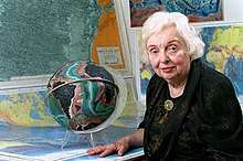 Marie Tharp in July 2001 | |
| Born | July 30, 1920 |
| Died | August 23, 2006 (aged 86) |
| Nationality | United States |
| Citizenship | United States |
| Alma mater | Ohio University University of Michigan University of Tulsa |
| Known for | Seafloor topography |
| Scientific career | |
| Fields | Geology, Oceanography |
| Institutions | Lamont-Doherty Earth Observatory |
.jpg)

Early life
Marie Tharp was born to Bertha Louise Tharp, a German and Latin teacher, and William Edgar Tharp, a soil surveyor for the United States Department of Agriculture. Marie often helped him with this task, which gave her an early introduction to mapmaking. Due to the nature of William Tharp's work, the Tharp family moved constantly until William retired in 1931. At that point Marie had attended over 20 public schools in Alabama, Iowa, Michigan and Indiana. A full school year in Florence, Alabama, USA, was particularly influential for Marie. There, she attended a class called Current Science, in which she learned about contemporary scientists and the research projects they were working on. In addition, she got the chance to undertake school field trips on weekends to study trees and rocks[3].
Education
After his retirement, William Tharp and the rest of the family moved to a farm in Bellefontaine, Ohio where, shortly after, Marie graduated from high school.[1] Influenced by her mother, a teacher, she took a year off before going to college; after graduating, she too planned to become a teacher. Staying on the farm to help after her mother’s death in 1936, Marie later matriculated in college.[4] Advised by her father to choose a subject of study that she not only loved, but also would provide her with a career and financial security, Tharp graduated from Ohio University in 1943 with bachelor's degrees in English and music and four minors. After the attack on Pearl Harbour by the Japanese army, many young men dropped out of schools and universities to join the armed forces.[5] World War II hence meant more women were being recruited into professions like petroleum geology, hitherto largely restricted to men. Having taken a geology class at Ohio, Tharp was recruited to the University of Michigan at Ann Arbor's petroleum geology program, where she completed a master's degree.[6] Tharp's leap into a career in earth sciences is extraordinary given longstanding discrimination against women in this field — women obtained fewer than 4% of all earth sciences doctorates at this time.[7] She took a job at the Stanolind Oil company in Tulsa, Oklahoma, as a junior geologist, but soon found it unsatisfying. At that time, in fact, women were not allowed to go on field trip to look for oil and gas. She was therefore confined to the office, where her duties were to collect the maps and data for the men going in the field.[5] While still working as a geologist for the Stanolind Oil company, Tharp enrolled in the faculty of mathematics at the University of Tulsa, obtaining her second BSc.[5] In 1948, Tharp had spent 4 years in Tulsa and was looking for her next career step. At that time, she moved to New York to work with Maurice Ewing, the founder of Columbia University’s Lamont Geological Observatory, as a research assistant. Curiously, when interviewed for the job, Tharp did not mention she had a master's degree in geology.[8]
Career
Tharp moved to New York in 1948, where Maurice Ewing employed her at the Lamont Geological Laboratory (now the Lamont-Doherty Earth Observatory) at Columbia University, initially as a general drafter.[9] Before the early 1950s, scientists knew very little about the structure of the ocean floor. Studying the field of geology on land was cheaper and easier. The complete idea of the structure of the entire earth could not be accomplished without knowledge of the structure and evolution of the seafloor. Marie Tharp was one of the first women to work at the Lamont Geological Observatory. There, Tharp met Bruce Heezen, and in early work together they used photographic data to locate downed aircraft from World War II.[10] Tharp was employed and continuously promoted from 1952 to 1968, when her position was cut and moved to grant-funded status due to lab politics involving Heezen (she remained in a grant-funded position until Heezen's death in 1977). Because of the Cold War, the U.S. government forbade seafloor maps to be published, for fear that Soviet submarines could use them.[5] In 1952 Heezen and Tharp began working together to map the topography of the ocean floor. For the first 18 years of their collaboration, Heezen collected bathymetric data aboard the research ship, the Vema, while Tharp drew maps from that data, since women were still excluded from working aboard ship at that time. Although restricted, early in her career, from conducting research at sea due to her gender, Tharp was later able to join a 1968 data-collection expedition. Tharp independently used data collected from the Woods Hole Oceanographic Institution's research ship Atlantis, and seismographic data from undersea earthquakes. Her work with Heezen represented the first systematic attempt to map the entire ocean floor.
The theory of continental drift
In 1952, Tharp painstakingly aligned sounding profiles from Atlantis, acquired during 1946 - 1952, and one profile from the Naval ship Stewart acquired during 1921. She created a total of approximately six profiles stretching west-to-east across the North Atlantic. From these profiles, she was able to examine the bathymetry of the northern sections of the Mid-Atlantic Ridge. Tharp identified an aligned, v-shaped structure running continuously through the axis of the ridge and believed that it may be a rift valley.[9][11] She believed that the rift valley formed when new material welled up to the surface, pushing either side of the ridge apart.[9] Heezen was initially unconvinced as the idea would have supported continental drift, then a controversial theory. At the time many scientists including Heezen believed that continental drift was impossible. Instead, for a time he favored the expanding Earth hypothesis,[12][13] ridiculing her theory as "girl talk".[14]
Heezen soon hired Howard Foster to plot the location of earthquake epicenters in the oceans for a project relating large-scale turbidity currents to undersea earthquakes. The creation of this earthquake epicenter map proved to be a useful secondary dataset for examining the bathymetry of the Mid-Atlantic Ridge. When Foster's map of earthquake epicenters was overlain with Tharp's profile of the Mid-Atlantic Ridge it became clear that the location of these earthquakes aligned with Tharp's rift valley. After putting together these two datasets, Tharp became convinced that a rift valley did in fact exist within the crest of the Mid-Atlantic Ridge.[9] It was only after seeing that the location of earthquake epicenters aligned with Tharp's rift valley that Heezen accepted her hypothesis and turned to the alternative theories of plate tectonics and continental drift.[15][16]
.jpg)
Tharp and Heezen published their first physiographic map of the North Atlantic in 1957.[9] Still, Tharp's name does not appear on any of the major papers on plate tectonics that he and others published between 1959 and 1963. Tharp continued working with graduate student assistants to further map the extent of the central rift valley. Tharp identified that the rift valley extended along with the Mid-Atlantic Ridge into the South Atlantic,[9] and found a similar valley structure in the Indian Ocean, Arabian Sea, Red Sea, and Gulf of Aden, suggesting the presence of a global oceanic rift zone.[17] Subsequently, in collaboration with the Austrian landscape painter Heinrich Berann, Tharp and Heezen realized their map of the entire ocean floor, which was published in 1977 by National Geographic under the title of The World Ocean Floor[5]. Although still recognized and attributed to for her work today on the Mid-Atlantic Ridge, it was Heezen, who at the time in 1956, put out and received credit for the discovery that was made.
Retirement and death
After Heezen's death, Tharp continued to serve on the faculty of Columbia University until 1983, after which she operated a map-distribution business in South Nyack during her retirement[18]. Tharp donated her map collection and notes to the Map and Geography Division of the Library of Congress in 1995.[19] In 1997, Tharp received double honors from the Library of Congress, which named her one of the four greatest cartographers of the 20th century and included her work in an exhibit in the 100th-anniversary celebration of its Geography and Map Division.[20] In 2001, Tharp was awarded the first annual Lamont-Doherty Heritage Award at her home institution for her life's work as a pioneer of oceanography.[2] Tharp died of cancer in Nyack, New York on August 23, 2006 at the age of 86.[21]
Personal life
In 1948, she married David Flanagan and moved with him to New York. They were divorced by 1952.[22]
In popular culture
Marie Tharp appears in The Lost Worlds of Planet Earth, the ninth episode of Neil deGrasse Tyson’s science documentary show Cosmos: A Spacetime Odyssey in animation form voiced by actress Amanda Seyfried. The episode depicts her discovery of the Mid-Atlantic Ridge and subsequently later in the episode deGrasse Tyson recognized Tharp not only as an influential scientist who happens to be a woman but also as one who should be recognized as a scientist who overcame sexism to contribute to her field.[23]
Posthumous recognition
In 2009, Google Earth included the Marie Tharp Historical Map layer, to allow people to view Tharp's ocean map using the Google Earth interface.[24]
In 2013, author Hali Felt published a biography of Marie Tharp entitled Soundings: The Story of the Remarkable Woman Who Mapped the Ocean Floor.[25] It was cited by the New York Times for its standing as an "eloquent testament both to Tharp's importance and to Felt's powers of imagination."[26]
In 2015 the International Astronomical Union named a Moon Crater in her honour.
In 2020, a group of geologists began selling mugs with a photo of Tharp, donating all proceeds to the Earth Science Women's Network.[27]
Awards
Like many women of her era in science, Marie Tharp was recognized mainly later in life. She was awarded noteworthy recognition such as:
1978 - National Geographic Society’s Hubbard Medal
1996 - Society of Woman Geographers Outstanding Achievement Award
1999 - Woods Holes Oceanographic Institution’s Mary Sears Woman Pioneer in Oceanography Award
2001 - Lamont–Doherty Earth Observatory Heritage Award[28]
Marie Tharp Fellowship
Lamont had created the Marie Tharp Visiting Fellowship Program in 2004. Women who are accepted are given the opportunity to work with the faculty, research staff, postdoctoral researchers and graduate students. Additionally in the duration of 3 months, they are awarded up to $30,000 as financial aid to promote up-and-coming women researchers.[29][30] The Marie Tharp Fellowship is a competitive academic visiting fellowship awarded to women to work with researchers at Columbia University's Earth Institute.[31][32]
Journal articles
- Heezen, B C; Bunce, Elizabeth T; Hersey, J B; Tharp, Marie (1964). "Chain and Romanche fracture zones". Deep-Sea Research and Oceanographic Abstracts. 11 (1): 11–33. Bibcode:1964DSROA..11...11H. doi:10.1016/0011-7471(64)91079-4.
- Heezen, B C; Tharp, Marie (1965). "Tectonic fabric of the atlantic and indian oceans and continental drift". Philosophical Transactions of the Royal Society of London A. 258 (1088): 90–106. Bibcode:1965RSPTA.258...90H. doi:10.1098/rsta.1965.0024.
- Tharp, Marie; Friedman, Gerald M (2002). "Mapping the world ocean floor". Northeastern Geology and Environmental Sciences. 24 (2): 142–149..
References
- "Marie Tharp | Encyclopedia.com". www.encyclopedia.com. Retrieved 2019-02-07.
- Lamont-Doherty Earth Observatory Bestows Heritage Award on Marie Tharp, Pioneer of Modern Oceanography, Published Jul 10, 2001, Retrieved Oct 12, 2014
- "Marie Tharp - Plate Tectonics Pioneer" (PDF).
- "Marie Tharp - Ages of Exploration". Retrieved 2019-02-07.
- Yount, L. (2006). Modern Marine Science: Exploring the Deep. Facts On File, Incorporated. ISBN 9781604130669.
- Barton, Cathy (2002). "Marie Tharp, oceanographic cartographer, and her contributions to the revolution in the Earth sciences". Geological Society, London, Special Publications. 192 (1): 215–228. Bibcode:2002GSLSP.192..215B. CiteSeerX 10.1.1.1032.1530. doi:10.1144/gsl.sp.2002.192.01.11.
- Blakemore, Erin (2016-08-30). "Seeing Is Believing: How Marie Tharp Changed Geology Forever". Smithsonian.
- A Student's Guide to Earth Science, Volume 2. Greenwood Publishing Group. 2004. ISBN 031332901X.
- Tharp, M. (2006-12-12). "Marie Tharp biography". Woods Hole Oceanographic Institution. Retrieved 2008-06-02.
- Evans, R. (November 2002). "Plumbing Depths to Reach New Heights". Retrieved 2008-06-02.
- North, Gary W. (2010-01-01). "Marie Tharp: The lady who showed us the ocean floors". Physics and Chemistry of the Earth, Parts A/B/C. 35 (15–18): 881–886. Bibcode:2010PCE....35..881N. doi:10.1016/j.pce.2010.05.007. ISSN 1474-7065.
- Barton, C. (2002). "Marie Tharp, oceanographic cartographer, and her contributions to the revolution in the Earth sciences". Geological Society, London, Special Publications. 192 (1): 215–228. Bibcode:2002GSLSP.192..215B. CiteSeerX 10.1.1.1032.1530. doi:10.1144/GSL.SP.2002.192.01.11.
- Doel, R.E.; Levin, T.J.; Marker, M.K. (2006). "Extending modern cartography to the ocean depths: military patronage, Cold War priorities, and the Heezen-Tharp mapping project, 1952–1959". Journal of Historical Geography. 32 (3): 605–626. doi:10.1016/j.jhg.2005.10.011.
- Tharp, Marie (1999). "Chapter 2: Connect the Dots: Mapping the Seafloor and Discovering the Mid-ocean Ridge". In Lippsett, Laurence (ed.). Lamont-Doherty Earth Observatory of Columbia, Twelve Perspectives on the First Fifty Years 1949-1999. Lamont-Doherty Earth Observatory of Columbia University, Palisades, NY. OCLC 43636190.
- Felt, Hali (2017). "ROCK STARS: Marie Tharp - Plate Tectonics Pioneer". GSA Today. 27: 32–33.
- Wills, Matthew (2016-10-08). "The Mother of Ocean Floor Cartography". JSTOR. Retrieved 2016-10-14.
While working with the North Atlantic data, she noted what must have been a rift between high undersea mountains. This suggested earthquake activity, which then [was] only associated with [the] fringe theory of continental drift. Heezen infamously dismissed his assistant's idea as "girl talk." But she was right, and her thinking helped to vindicate Alfred Wegener's 1912 theory of moving continents. Yet Tharp's name isn't on any of the key papers that Heezen and others published about plate tectonics between 1959–1963, which brought this once-controversial idea to the mainstream of earth sciences.
- 1961-, Lawrence, David M. (2002). Upheaval from the abyss : ocean floor mapping and the Earth science. Rutgers University Press. ISBN 978-0813530284. OCLC 605755403.CS1 maint: numeric names: authors list (link)
- "PennState - College of Earth and Mineral Sciences - Marie Tharp".
- "Primary Sources in Science Classrooms: Mapping the Ocean Floor, Marie Tharp, and Making Arguments from Evidence (Part 1) | Teaching with the Library of Congress". blogs.loc.gov. 2015-10-08. Retrieved 2015-10-29.
- Jarvis, Brooke (2014-12-09). "How One Woman's Discovery Shook the Foundations of Geology". mentalfloss.com.
- Fox, Margalit (August 26, 2006). "Marie Tharp, Oceanographic Cartographer, Dies at 86". New York Times. Retrieved April 9, 2012.
- Felt, Hali (2012). Soundings: The Story of the Remarkable Woman Who Mapped The Ocean Floor. Henry Holt.
- Algar, Jim (2014-05-07). "Cosmos Episode 9 'The Lost Worlds of Planet Earth': Amanda Seyfried walks us through Earth's early past". TECH TIMES. Retrieved 6 February 2019.
- Google Earth drops into the oceans, Guardian News, 2 February 2009, Retrieved Oct 12, 2014,
- Macmillan Publishers: Hali Felt Archived 2016-01-19 at the Wayback Machine, Retrieved Oct 12, 2014
- Floating Ideas: ‘Soundings,’ About Marie Tharp, by Hali Felt, New York Times, 25 January 2013, Retrieved Oct 12, 2014
- stan, marie tharp (2020-03-04). "amazing testimonials... a marie tharp mug will change your life people. and all proceeds go to support earth science womens network". @palaeobak. Retrieved 2020-03-05.
- "Marie Tharp". Physics Today. 2018-07-30. doi:10.1063/PT.6.6.20180730a.
- "Applications Now Being Accepted for Marie Tharp Visiting Fellowship". The Earth Institute Columbia University. Retrieved 6 February 2019.
- "Marie Tharp". Penn State College of Earth and Mineral Sciences. Retrieved 6 February 2019.
- "Marie Tharp Fellowship Information" (PDF). earth.columbia.edu. Columbia University. 2013.
- "The Marie Tharp Fellowship". earth.columbia.edu. The Earth Institute, Columbia University. Archived from the original on 2018-07-08. Retrieved 2016-08-22.
Further reading
- C250 Celebrates 250 Columbians Ahead of Their Time: Entry on Marie Tharp.
- Woods Hole Oceeanographic Institution. "Marie Tharp Honored at Women Pioneers Seminar."
- The Earth Institute at Columbia University. "Mapping Methodology Examples (North Atlantic)."
- The Earth Institute at Columbia University. "Marie Tharp, Pioneering Mapmaker of the Ocean Floor, Dies." Earth Institute News, August 23, 2006.
- Nelson, Valerie. "Marie Tharp, 86; Pioneering Maps Altered Views on Seafloor Geology." The Los Angeles Times, September 4, 2006.
- Hall, Stephen S. "The Contrary Map Maker" The New York Times Magazine, December 31, 2006.
- Felt, Hali (2012). Soundings: The Story of the Remarkable Woman Who Mapped the Ocean Floor. New York: Henry Holt and Co. ISBN 9780805092158.
- Doel, Ronald (1970–1980). "Tharp, Marie". Dictionary of Scientific Biography. 25. New York: Charles Scribner's Sons. pp. 29–31. ISBN 978-0-684-10114-9.
External links
| Library resources about Marie Tharp |
| By Marie Tharp |
|---|
| Authority control |
|
|---|